
This page holds the official NCERT Class 12 Geography Chapter 7 Transport and Communication PDF from the book India: People and Economy, along with a working breakdown of what the chapter contains.
Transport and communication class 12 is a data-heavy chapter: it covers how India moves goods, people and messages by road, rail, water, air, pipeline and satellite, and its exercises test exactly those facts. The official chapter PDF is linked directly below.
| What the chapter holds | Count | Where it is used |
|---|---|---|
| Printed pages | 11 | |
| Figures with NCERT captions | 12 | |
| Tables | 3 | |
| Exercise questions | 3 | answered in our NCERT Solutions |
| Activities | 1 | |
| Official NCERT PDF | Download the chapter PDF | the chapter exactly as NCERT publishes it |
Transport and Communication Class 12 Chapter PDF
The official NCERT Class 12 Geography Chapter 7 Transport and Communication PDF is published on the NCERT textbook portal, which keeps the unedited chapter text, its three data tables and all its figures, so the file you open there is exactly the chapter as NCERT printed it.
Chapter 7 at a Glance
The table below shows how much this chapter holds — its sections, figures, tables and exercise questions — so you can see at a glance the size of the file you are about to study.
Beyond the numbers, this chapter is text-and-data heavy. Its three printed data tables are Table 7.1 (India Road Network 2020), Table 7.2 (railway zones and headquarters) and Table 7.3 (national waterways). It carries several “Do You Know” boxes and a three-question exercise set. There are no formulas or worked numerical examples — what it demands is accurate recall of names, years and routes.
What This Chapter Covers: Moving Goods, People and Messages
The chapter opens with a single idea: everything we use daily — from toothpaste to milk and clothes — must be transported from the site of production to the market where we buy it (NCERT, p. 1). Communication does the same job for immaterial things: we exchange views, ideas and messages between places and between people.
The use of both depends on need — the need to move things from the place of availability to the place of use.
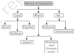
The diagram above is the chapter’s organising scheme. It groups the major means of transportation into the families the book then takes up one by one: land transport (roads, then railways), water transport (inland waterways, then oceanic routes), air transport, and pipelines.
- Land transport — roads first, then railways. This is the longest stretch of the chapter.
- Water transport — inland waterways, then oceanic routes.
- Air transport and oil and gas pipelines — the fastest mode, and the most convenient for liquids and gases.
- Communication networks — personal communication, radio, television and satellites (NCERT, pp. 9-10).
The chapter moves outward: it starts with the goods we use daily, moves to the networks that carry them, and finishes with the systems that carry our messages. Keep that shape in mind and the exercise set at the end will map onto it section by section.
Key Concepts: The Five Means of Transport
For every mode the chapter works through, the core to learn is the same three things: what it carries, who builds and maintains it, and one or two signature numbers. The five sub-sections below give you all three for each mode, with the NCERT page cited so you can check the book as you revise.
Roads: Classification and National Corridor Projects
Roads carry the bulk of India’s passenger and freight movement, and the chapter classifies them not by surface but by who builds and maintains them (NCERT, p. 2). Learn the categories first, then attach the number that goes with each.
The classification diagram above sets the frame: National Highways, State Highways, District Roads and Rural Roads. The chapter adds a fifth working category, Other Roads, which covers border roads and international highways.
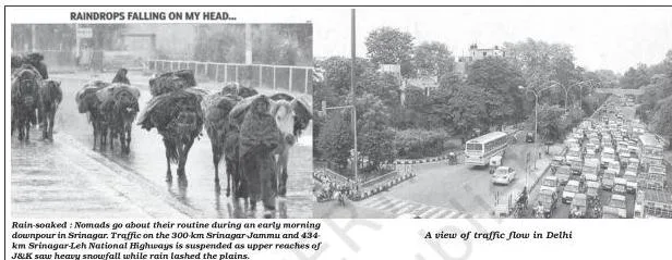
National Highways are constructed and maintained by the Central Government. They serve inter-state transport and defence movement, and connect state capitals, major cities, important ports and railway junctions. Their length rose from 19,700 km in 1951 to 1,36,440 km in 2020 — yet National Highways are only about 2 per cent of the total road length while carrying 40 per cent of the road traffic (NCERT, p. 2).
The National Highways Authority of India (NHAI), operationalised in 1995, handles their development, maintenance and operation.
NHAI’s flagship projects are the ones most often quoted:
- Golden Quadrilateral — 5,846 km of 4/6-lane high-density corridor joining Delhi, Mumbai, Chennai and Kolkata.
- North–South Corridor — 4,076 km from Srinagar to Kanniyakumari, including the Cochin–Salem spur.
- East–West Corridor — 3,640 km from Silchar (Assam) to Porbandar (Gujarat).
- Bharatmala Pariyojana — about 26,000 km of economic corridors, plus ring roads, bypasses and elevated corridors to decongest traffic passing through cities (NCERT, p. 5).
State Highways are constructed and maintained by state governments and join state capitals with district headquarters and other important towns. District Roads are the connecting link between district headquarters and the other important nodes of the district (NCERT, p. 3).
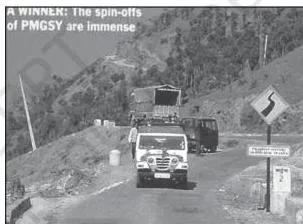
Rural Roads are the largest category by length — about 80 per cent of the total road length in India (NCERT, p. 3). Their density varies with the nature of the terrain, and the chapter asks you to explain why hilly, plateau and forested areas have very low rural road density.
The answer lies in the terrain itself: rugged relief and dense forest make building and maintaining roads costly, so networks stay thin. The photograph above shows a road built under the Pradhan Mantri Gram Sadak Yojna — the national programme that targets exactly this rural connectivity gap.
Quality also deteriorates away from urban centres, because maintenance effort concentrates where traffic is heaviest.
Other Roads means Border Roads and International Highways. The Border Roads Organisation (BRO), established in May 1960, builds and maintains strategically important roads along India’s northern and north-eastern boundary — the road joining Chandigarh with Manali and Leh runs at an average altitude of about 4,270 m — and clears snow in high-altitude areas (NCERT, p. 3).
In 2020 the BRO completed the 9.02 km Atal Tunnel in the Pir Panjal range, which keeps the Manali–Lahaul-Spiti valley connected throughout the year (NCERT, p. 4).
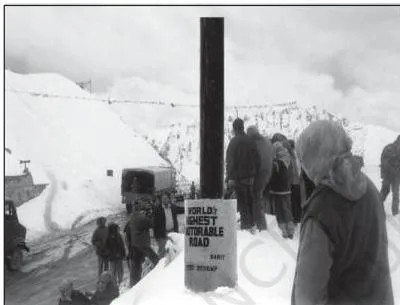
The photograph of Khardung La in Ladakh is the chapter’s visual proof of what BRO roads look like: roads carved through high-altitude passes on the northern border. It pairs with the Atal Tunnel to show how far Indian road engineering now reaches into the mountains.
International highways exist to promote harmonious relationships with neighbouring countries by providing effective links with India (NCERT, p. 3). The two photographs below show that category in action.
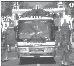
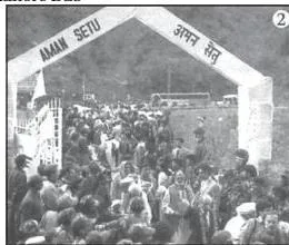
The Delhi–Lahore bus at the Wagah border and the Aman Setu bridge between Baramula and Muzaffarabad are the chapter’s two examples of international road links. Both belong to the Other Roads category, and both illustrate the point that some highways exist for cross-border links rather than domestic traffic alone.
A “Do You Know” box adds the historical layer: Sher Shah Suri built the Shahi (Royal) road from the Indus Valley to the Sonar Valley in Bengal; the British renamed it the Grand Trunk (GT) road, and it now extends from Amritsar to Kolkata.
The same box notes that the 1943 Nagpur Plan was the first serious attempt at modern road development but was never implemented, and that a twenty-year road plan followed in 1961. The chapter’s road data comes from the Ministry of Road Transport and Highways (morth.nic.in, Annual Report 2026-27).
Railways: Zones, Gauges and the Konkan Line
Railways move the masses and form the country’s largest government undertaking, but the chapter’s testable core is a short list of dates, numbers and categories (NCERT, pp. 5-6).
Indian Railways began in 1853 with a 34 km line from Bombay to Thane. The network has grown to 67,956 km (Railway Yearbook 2026-27) and is divided into 17 zones — the exact fact asked in Exercise Q1(i). The chapter’s Table 7.2 lists all 17 zones with their headquarters; you do not need to memorise the table, only the count and what the table exists for.
Mahatma Gandhi said the railways “…brought people of diverse cultures together to contribute to India’s freedom struggle”. The chapter uses the quote to make the point that railways matter beyond economics — they are the thread that holds a diverse country together.
The three railway gauges, from the “Do You Know” box, form a clean comparison table:
| Gauge | Distance between rails | Route length (2026-27) |
|---|---|---|
| Broad gauge | 1.676 m | 63,950 km |
| Metre gauge | 1 m | 2,402 km |
| Narrow gauge | 0.762 m or 0.610 m | 1,604 km |
Narrow gauge is generally confined to hilly areas. Indian Railways has an extensive programme to convert metre and narrow gauges to broad gauge, and steam engines have been replaced by diesel and electric engines, raising speed and haulage capacity while improving station environments. Metro rail and CNG-run buses in cities are the chapter’s examples of cleaner urban transport (NCERT, p. 5).
One pattern is worth a revision line: the British-era network developed around towns, raw-material areas, plantations, hill stations and cantonment towns, built largely for resource exploitation, while the post-Independence network extended to new areas. Even so, density remains low in the hill states, the north-eastern states, the central parts of India and Rajasthan.
The chapter’s major rail achievement of recent decades is the Konkan Railway: opened in 1998, it runs 760 km from Roha in Maharashtra to Mangalore in Karnataka, crossing 146 rivers and streams, about 2,000 bridges and 91 tunnels — with Asia’s largest tunnel, about 6.5 km long, on the route (NCERT, p. 6).
Notice it is a railway along the western coast, not a waterway — a distinction the exercise section below warns about.
Water Transport: National Waterways and Ocean Routes
Water is the cheapest means of transport and the most suitable for carrying heavy and bulky material; it is also fuel-efficient and eco-friendly (NCERT, p. 6). The chapter splits it into inland waterways and oceanic routes.
Inland waterways — rivers, canals, backwaters and creeks — were the chief mode of transport before the railways arrived, then lost ground to road and rail competition and to irrigation diversions that made large stretches of rivers non-navigable. India still has 14,500 km of navigable waterways, contributing about 1 per cent of the country’s transportation.
The Inland Waterways Authority was set up in 1986, and the National Waterways Act, 2016 declared 111 inland waterways (including the five declared earlier) as National Waterways.
| Waterway | Stretch | Length |
|---|---|---|
| NW 1 | Ganga, Prayagraj–Haldia | 1,620 km |
| NW 2 | Brahmaputra, Sadiya–Dhubri | 891 km |
| NW 3 | West-coast canal system, Kottapuram–Kollam | 205 km |
| NW 4 | Godavari and Krishna stretches with Kakinada–Puducherry canals | 1,078 km |
| NW 5 | Brahmani with Mahanadi delta channels and East Coast canals | 588 km |
The chapter’s Table 7.3 gives the details of these five stretches. NW 1, on the Ganga, is navigable by mechanical boats up to Patna and by ordinary boats up to Haridwar, and is developed in three parts: Haldia–Farakka, Farakka–Patna and Patna–Prayagraj.
The backwaters (Kayal) of Kerala carry special significance — a cheap means of transport, a major tourist attraction and the home of the famous Nehru Trophy Boat Race (Vallamkali).
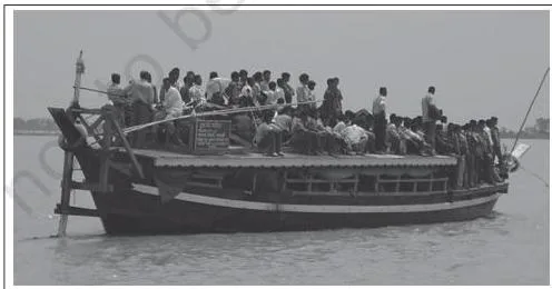
The photograph of river navigation in the north-east illustrates the inland network in the region drained by the Brahmaputra — the river of NW 2, which the book notes is navigable by steamers up to Dibrugarh. This is the part of India where rivers, not roads, carry much of the everyday traffic.
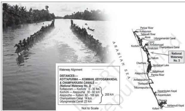
Figure 7.7 is a map of National Waterway 3 — the Kottapuram–Kollam stretch of 205 km, which includes 168 km of west-coast canal plus the Champakara canal (14 km) and the Udyogmandal canal (23 km). Reading such maps is the one skill the water section expects: locate the stretch, then quote its length.
Oceanic routes rest on India’s coastline of about 7,517 km including islands, served by 12 major and 200 minor ports. Approximately 95 per cent of India’s foreign trade by volume and 70 per cent by value moves through ocean routes — a pair of numbers worth keeping distinct from the road-freight 70 per cent.
Ocean routes also carry transport between the islands and the rest of the country (NCERT, p. 8).
Air Transport and Pipelines
Air is the fastest means of movement — essential for a vast country with large distances and diverse terrain — while pipelines are the most convenient and efficient mode for transporting liquids and gases over long distances (NCERT, p. 8).
Air transport in India began in 1911 with an airmail operation over just 10 km, between Prayagraj and Naini; its real development came after Independence. The Airport Authority of India provides safe and efficient air traffic and aeronautical communication services in Indian air space.
Two names appear in the “Do You Know” box: UDAN (Ude Desh ka Aam Nagrik), the regional connectivity scheme designed to make flying affordable on regional and remote routes, and Pawan Hans, the helicopter service used in hilly and north-eastern areas, for tourism and by the petroleum sector.
Pipelines get a separate mental file because they move products, not people:
- OIL (Oil India Limited), incorporated in 1959, built Asia’s first cross-country pipeline — 1,157 km from the Naharkatiya oilfield in Assam to the Barauni refinery in Bihar, extended up to Kanpur in 1966.
- GAIL (India) Ltd, set up in 1984, built the first 1,700 km Hazira–Vijaipur–Jagdishpur (HVJ) gas pipeline, linking the Mumbai High and Bassein gas fields with fertiliser, power and industrial complexes in western and northern India.
- India’s gas infrastructure has grown over ten times, from 1,700 km to 18,500 km of cross-country pipelines, with a Gas Grid target of over 34,000 km linking all gas sources and consuming markets.

The pipeline diagram above makes the chapter’s point visually: pipelines carry liquids and gases over long distances — and even solids, once they are converted into slurry.
That is why the chapter calls them the most convenient mode for these products; their limitation, which a balanced answer should note, is that a pipeline serves only the products it was built for, along one fixed route.
Communication Networks: From Radio to Satellites
The chapter’s second half switches from moving goods to moving messages, and here the years matter as much as the ideas (NCERT, p. 9).
The section opens with a short history: early humans sent messages by drum, smoke, fire and fast runners, then with horses, camels, dogs and birds; the invention of the post office, telegraph, printing press, telephone and satellite made communication far faster and easier.
On the basis of scale and quality, the modes of communication are divided into personal and mass communication.
Personal communication: among all personal communication systems, the internet is the most effective and advanced. It gives direct contact through e-mail, access to a vast world of knowledge and information, and is increasingly used for e-commerce and money transactions — all at comparatively low cost. It is widely used in urban areas.
Radio: broadcasting began in 1923 with the Radio Club of Bombay, was brought under government control as the Indian Broadcasting System in 1930, became All India Radio in 1936 and was renamed Akashwani in 1957. All India Radio broadcasts programmes of information, education and entertainment, with special news bulletins during sessions of Parliament and state legislatures.
Television: TV began in 1959, limited to the National Capital; after 1972 other centres became operational. In 1976 it was delinked from All India Radio and got a separate identity as Doordarshan. Once INSAT-IA (National Television-DDI) became operational, Common National Programmes were started and TV services were extended to backward and remote rural areas.
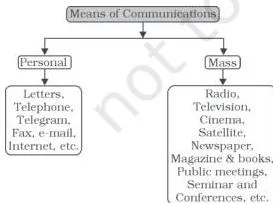
The communication diagram above is the section’s organising picture: all the modes people use to convey messages, sorted by scale and quality. When you revise, sort every date in this section into the same two boxes — personal and mass communication.
Satellite communication: India’s satellites are grouped into two systems. The INSAT (Indian National Satellite System), established in 1983, is a multipurpose system for telecommunication, meteorological observation and various other data and programmes. The IRS (Indian Remote Sensing Satellite System) became operational with the launch of IRS-IA in March 1988 from Vaikanour in Russia.
India has developed its own launcher, the PSLV (Polar Satellite Launch Vehicle), and the National Remote Sensing Centre (NRSC) at Hyderabad handles the acquisition and processing of data. Satellite images are used for weather forecasting, monitoring natural calamities, surveillance of border areas and management of natural resources (NCERT, p. 10).
| Year | Communication milestone |
|---|---|
| 1923 | First radio broadcast by the Radio Club of Bombay |
| 1930 | Radio brought under the Indian Broadcasting System |
| 1936 | All India Radio |
| 1957 | Renamed Akashwani |
| 1959 | Television begins in the National Capital |
| 1976 | Television delinked from AIR as Doordarshan |
| 1983 | INSAT established |
| 1988 | IRS-IA launched; IRS system operational |
This timeline is the most useful consolidation table in the chapter — every year in it either answers an exercise question directly (1923 in Exercise Q1(iii)) or sits inside a plausible option.
Reading the Chapter’s Figures: What Each Diagram Demonstrates


The figures in this chapter are not decoration — each one carries a fact the text leans on, so revision should treat them as labelled facts. The table below tells you what to notice in each figure shown above and which textbook fact it supports.
| Figure | What to notice | Fact it carries |
|---|---|---|
| Major means of transportation diagram | The chapter’s opening organisation chart | Transport families: land, water, air and pipelines |
| Fig 7.1 | Road hierarchy from National Highways down to rural roads | Roads are classified by who constructs and maintains them |
| Fig 7.2 | A rural road built under a national programme | Rural roads are about 80 per cent of road length and receive dedicated programme support |
| Fig 7.3 | A high-altitude pass road in Ladakh | BRO builds and maintains roads in mountainous border terrain |
| Fig 7.4 | Delhi–Lahore bus at the Wagah border | International highways link India with neighbouring countries |
| Fig 7.5 | Aman Setu between Baramula and Muzaffarabad | International road links also run along the north-western border |
| Fig 7.6 | River navigation in the north-east | Inland waterways, especially the Brahmaputra (NW 2), are working routes |
| Fig 7.7 | Map of National Waterway 3 | NW 3 is the Kottapuram–Kollam west-coast canal system |
| Pipeline diagram | Pipelines moving liquids and gases over long distances | Pipelines are the most convenient mode for liquids and gases |
| Communication diagram | Modes of communication people use to convey messages | Communication is classified by scale and quality |
Definitions to Remember From This Chapter
Exercise Q2 asks for short “define and discuss” answers, so keep these definitions exam-ready in your own words. Each one below matches the meaning the chapter gives, with the page cited.
| Term | Definition |
|---|---|
| Transportation | The movement of goods and items from the site of production to the market or place of use (NCERT, p. 1) |
| Communication | The exchange of views, ideas and messages between people and places (NCERT, p. 1) |
| National Highways | Main roads constructed and maintained by the Central Government, for inter-state transport, defence movement, and links between capitals, ports and junctions (NCERT, p. 2) |
| State Highways | Roads maintained by state governments that join state capitals with district headquarters and important towns (NCERT, p. 3) |
| District Roads | Roads connecting district headquarters with the other important nodes of the district (NCERT, p. 3) |
| Rural Roads | Roads that provide links within rural areas; about 80 per cent of total road length (NCERT, p. 3) |
| Inland waterways | Rivers, canals, backwaters and creeks used for navigation (NCERT, p. 6) |
| National Waterways | Waterways declared under the National Waterways Act, 2016 — 111 in all, including the five declared earlier (NCERT, p. 6) |
| Personal communication system | Direct individual-to-individual communication; the internet is its most effective and advanced form (NCERT, p. 9) |
Common Mistakes in This Chapter (and the Correct Facts)
The objective questions in the exercise set are built around look-alike facts, so the mistakes students make here are predictable. This chapter has no SUMMARY or Points to Ponder at its end, so the exercise options and the “Do You Know” boxes are the book’s own signals of what it emphasises.
| Mistake | Correct rule | How to check your answer |
|---|---|---|
| The railways are divided into 14 zones | The Indian Railways system is divided into 17 zones (NCERT, p. 5) | Count the zones in Table 7.2 — it lists 17 zones with their headquarters |
| NW 1 lies on the Brahmaputra, between Sadiya and Dhubri | NW 1 is on the Ganga between Haldia and Prayagraj; Sadiya–Dhubri is NW 2 on the Brahmaputra (NCERT, p. 6) | Match each waterway to its river before matching its towns: Ganga → NW 1, Brahmaputra → NW 2 |
| The first radio broadcast was in 1911 | Radio began in 1923 with the Radio Club of Bombay; 1911 is the year of the first airmail operation between Prayagraj and Naini (NCERT, pp. 8-9) | Attach 1911 to the air, 1923 to the radio |
| National Highways carry 85 per cent of road traffic | NHs are about 2 per cent of road length but carry 40 per cent of road traffic; 85 per cent is the passenger share of all roads (NCERT, p. 2) | Ask “percentage of what?” — road length or traffic, and which roads |
| Rural roads are a small share of the network | About 80 per cent of total road length in India is rural roads (NCERT, p. 3) | Pair 80 per cent with rural road length, 85 per cent with passenger traffic |
| Konkan Railway is a waterway along the west coast | It is a 760 km rail route opened in 1998, from Roha to Mangalore, crossing 146 rivers and streams, about 2,000 bridges and 91 tunnels (NCERT, p. 6) | The name says Railway — it crosses rivers rather than sailing on them |
| INSAT and IRS are the same satellite system | INSAT (1983) is multipurpose — telecommunication and meteorological observation; IRS became operational with IRS-IA in March 1988 for remote sensing (NCERT, p. 10) | Match 1983 → INSAT, 1988 → IRS-IA |
Preparing for the Exams With This Chapter’s Exercises
The three questions at the end of the chapter are the book’s own test of what it values, and each maps to a clear part of the chapter (NCERT, pp. 10-11).
Q1 is objective recall. Each option is a real fact from a different section, so the question tests whether you can tell near-identical facts apart:
| Question | Correct answer | Where the fact sits |
|---|---|---|
| (i) In how many zones has the Indian Railways system been divided? | (c) 17 | Rail Transport section; Table 7.2 lists all 17 zones (NCERT, p. 5) |
| (ii) On which river and between which two places does National Waterway 1 lie? | (b) The Ganga, Haldia–Prayagraj | Inland Waterways; Table 7.3 (NCERT, p. 6) |
| (iii) In which year was the first radio programme broadcast? | (d) 1923 | Radio section — Radio Club of Bombay (NCERT, p. 9) |
The wrong options are real facts from other sections: the Brahmaputra option in Q1(ii) is NW 2, the West Coast Canal option is NW 3 and the Godavari option is NW 4; in Q1(iii), 1911 is the airmail year and 1936 is the year the service became All India Radio.
If you can place each fact in its section, you can answer every option.
Q2 asks for short answers of about 30 words — definition-plus-example answers:
- (i) Transportation conveys the movement of items from the site of production to the market or place of use. Name three major modes: land (road and rail), water and air — pipelines can be added as a fourth mode.
- (ii) For pipeline advantages, use the chapter’s own points: convenient and efficient for liquids and gases over long distances, and able to carry solids converted into slurry. For the discussion, note the limitation the chapter shows — a pipeline serves only the products it was built for, along one fixed route, so general goods and passengers still depend on roads and railways.
- (iii) Communication is the exchange of views, ideas and messages from one place or person to another (NCERT, p. 1).
Q3 asks for organised long answers of about 150 words. All three questions share the same architecture, so use the same five-step plan:
- Open with one framing sentence — define the mode or state its overall role in India’s economy.
- Give the development in time order, using the chapter’s dates (1853 for the first railway line, 1998 for Konkan Railway; 1923 to 1988 for the communication milestones).
- Use one short paragraph per factor or mode, each starting with its key fact.
- Support every paragraph with the chapter’s numbers — 67,956 km of railway, about 2 per cent of road length carrying 40 per cent of traffic, 95 per cent of foreign trade by volume by sea.
- Close with one evaluative sentence on economic importance — for example, transport as the link between production and consumption.
For Q3(i), draw the factors from the chapter itself: terrain (hill states, the north-east, central parts and Rajasthan have less dense rail networks; hilly and forested areas have low rural road density), historical development (British-era lines built around resource and plantation areas for exploitation) and economic need (post-Independence extension to new areas, and corridor projects linking the metros).
For Q3(ii), use the Gandhi quote as your importance point along with the mass movement of people and freight. For Q3(iii), build the answer on the 85 per cent passenger and 70 per cent freight share, the 2 per cent–40 per cent National Highway pair, and the corridor projects.
The chapter Activity asks why Bengaluru and Hyderabad in the south and Delhi, Kanpur and Patna in north India have emerged as important nodes. Answer with the chapter’s own logic: National Highways connect the state capitals, major cities, ports and railway junctions, and both roads and railways have historically concentrated in and around urban centres.
These five are large urban centres lying on the main transport corridors of the north and south, so high volumes of goods and passengers converge on them — which is what makes a city a node.
The Project at the end of the chapter (NCERT, p. 11) asks you to find out the facilities Indian Railways provides to passengers. Use it as a revision prompt: answer it with the chapter’s own material on zones, gauge conversion and metro/CNG improvements, then add current passenger amenities.
One honest caveat: textbook contents and the examinable syllabus are not always identical — check the current official CBSE syllabus for exactly what is assessable this session.
Transport and Communication: The Chapter’s Big Ideas in One Place
If you have time for only one section of this page, take this one — it is built to answer the exercise set. The two halves of the chapter answer one question together: how does a country of India’s size and diversity hold together?
Transport moves goods and people from where they are produced to where they are consumed; communication moves ideas and messages so that decisions, markets and cultures stay connected. Both concentrate where economic activity concentrates — in urban centres and along the corridors that join them.
The governing bodies and their years form the chapter’s easiest mark-scoring list. Learn them as one group:
| Body / Act | Year | Job |
|---|---|---|
| Oil India Limited (OIL) | 1959 | Exploration, production and transportation of crude oil and natural gas; built Asia’s first cross-country pipeline |
| Border Roads Organisation (BRO) | May 1960 | Builds and improves strategically important roads along the northern and north-eastern border; snow clearance |
| GAIL (India) Ltd | 1984 | Transport, processing and marketing of natural gas; built the HVJ pipeline |
| Inland Waterways Authority | 1986 | Development, maintenance and regulation of national waterways |
| National Highways Authority of India (NHAI) | 1995 (operationalised) | Development, maintenance and operation of National Highways |
| National Waterways Act | 2016 | Declared 111 inland waterways (including the earlier five) as National Waterways |
Memory aid: group the years by sector — roads: BRO 1960, NHAI 1995; waterways: IWA 1986, NW Act 2016; gas: OIL 1959, GAIL 1984; rail: first line 1853, Konkan Railway 1998; communication: 1923, 1936, 1957, 1959, 1976, 1983, 1988.
Five facts alone answer the objective questions:
- The Indian Railways system is divided into 17 zones.
- National Waterway 1 lies on the Ganga between Haldia and Prayagraj.
- The first radio programme was broadcast in 1923.
- National Highways are maintained by the Central Government — about 2 per cent of road length, 40 per cent of road traffic.
- The Konkan Railway, opened 1998, runs 760 km from Roha to Mangalore.
Related Chapters and Resources
Transport and Communication sits between two chapters in India: People and Economy. Use the links below to move around the book and the wider course:
- Class 12 Geography notes hub — chapter-by-chapter notes for India: People and Economy.
- Previous chapter: Planning and Sustainable Development in Indian Context.
- Next chapter: International Trade.
- Class 12 notes hub and the main CBSE notes library for the rest of the course.
The official unedited chapter and full textbook are published on the NCERT portal (linked at the top of this page), and the chapter’s road data comes from the Ministry of Road Transport and Highways — its site is the place to check for the latest road network figures.
Reference: NCERT Class 12 Geography textbook (India: People and Economy), chapter 7, official edition on ncert.nic.in.
Sources and Data Verification
This page describes the NCERT Class 12 Geography textbook India: People and Economy, Chapter 7, “Transport and Communication” — the chapter, its sections, figures and exercises as published by NCERT.
It covers this single chapter only. It does not describe the other Class 12 Geography books (Fundamentals of Human Geography and Practical Work in Geography) or chapters from other classes.
This listing is maintained for the current academic session using the NCERT information available to us.
NCERT settles textbooks, their editions and the official chapter PDFs; CBSE settles the curriculum, syllabus and examinations. To confirm a textbook edition, check NCERT; for what is examinable this session, check the current official CBSE syllabus.
Frequently Asked Questions About Transport and Communication Class 12
In how many zones has the Indian Railways system been divided?
The Indian Railways system has been divided into 17 zones (NCERT, p. 5). The chapter’s Table 7.2 lists all 17 zones with their headquarters, and Exercise Q1(i) offers 14 as the tempting wrong option.
On which river and between which two places does National Waterway 1 lie?
National Waterway 1 lies on the Ganga, between Haldia and Prayagraj — a 1,620 km stretch (NCERT, p. 6). The Brahmaputra option in the exercise (Sadiya–Dhubri) is NW 2, not NW 1.
In which year was the first radio programme broadcast in India?
In 1923, by the Radio Club of Bombay (NCERT, p. 9). Do not confuse it with 1911, the year of the first airmail operation between Prayagraj and Naini.
What is the difference between INSAT and IRS satellite systems?
INSAT (Indian National Satellite System), established in 1983, is multipurpose — telecommunication, meteorological observation and other data. IRS (Indian Remote Sensing Satellite System) became operational with the launch of IRS-IA in March 1988 and collects remote-sensing data used in the management of natural resources (NCERT, p. 10). In short: INSAT handles communication and weather; IRS handles earth observation.
Which roads are constructed and maintained by the Central Government?
National Highways are constructed and maintained by the Central Government (NCERT, p. 2). They connect state capitals, major cities, ports and railway junctions, and carry about 40 per cent of road traffic on only about 2 per cent of road length.
What is the Konkan Railway and why is it significant?
The Konkan Railway is a 760 km rail route opened in 1998, connecting Roha in Maharashtra to Mangalore in Karnataka (NCERT, p. 6). It is significant as an engineering marvel — it crosses 146 rivers and streams, about 2,000 bridges and 91 tunnels, including Asia’s largest tunnel of about 6.5 km — and it provides a direct rail link between Mumbai and Mangaluru along the western coast.
Explore Class 12 Geography Books
Related chapters: