
This page holds the official PDF and a plain-language walkthrough of Transport and Communication Class 12 NCERT Geography, Chapter 7 of Fundamentals of Human Geography. You will find the chapter’s main ideas below — the four modes of transport, every named route and canal, the maps, and what the exercises test.
Download the official file first if you want the textbook open beside you, or read the walkthrough before the PDF if the chapter has not yet made sense.
Download the Transport and Communication Class 12 PDF
NCERT hosts the official chapter file on its website at ncert.nic.in, and that file is the edition the board follows. Open the Transport and Communication Class 12 NCERT Geography Chapter 7 PDF (official file) to read the chapter with its maps and exercises exactly as printed.
Opening the official file is the reliable way to study — the PDF carries the same chapter in full, with its sections, figures, maps and closing exercises on screen.
| What the chapter holds | Count | Where it is used |
|---|---|---|
| Printed pages | 16 | |
| Figures with NCERT captions | 23 | |
| Exercise questions | 3 | answered in our NCERT Solutions |
| Activities | 1 | |
| Official NCERT PDF | Download the chapter PDF | the chapter exactly as NCERT publishes it |



Chapter at a Glance: What Is Inside the PDF
One table gives the chapter’s full shape — its sections, figures, activities and closing exercises — before you read on.
What This Chapter Covers: From Pack Animals to Cyberspace
This is a reading map in the book’s own order, so you know where every topic sits before you start revising.
The chapter opens with one argument: natural resources, economic activities and markets are rarely found in one place, so transport, communication and trade exist to link producing centres with consuming centres. Everything after that is detail built on this single idea.
- Transport and transport networks — what transport is, and how places and routes form a network pattern.
- Modes of transportation — land, water, air and pipelines, and the traffic each suits best.
- Land transport — pack animals, roads, highways, border roads, railways and trans-continental lines.
- Water transport — the six sea routes, the Suez and Panama canals, and the great inland waterways.
- Air transport and pipelines — the fastest mode and the invisible continuous one.
- Communications — satellite communication, cyberspace and the Internet, and how they shrink the world.
One honest warning before you start: this chapter is factual and route-heavy. It contains no formulas or derivations, so revision means memorising named routes, canals and numbers — and reading the maps carefully.
Key Concepts: Modes, Networks and Communication Links
The core ideas in the order the chapter builds them — understand these first, then attach the names and numbers to each idea.
Why Transport Exists: Linking Producers and Consumers
Transport exists because what a region produces and what it consumes are rarely in the same place.
Each region produces the items for which it is best suited, and exchange of those commodities relies on transport and communication. Efficient transport, communication and trade also underpin high living standards. That is why the chapter treats transport as an organised service industry every nation needs — including for defence.
One historical point sets up the rest of the book: in earlier days the means of transport and of communication were the same. Today they are distinct and specialised forms.
What a Transport Network Is: Nodes and Links
This is the chapter’s one structural definition — a single model that organises everything around it.
Places are the nodes, and routes are the links. Join several places by a series of routes, and the pattern they form is a transport network. Think of a city as a node and the highways radiating from it as links; the map of all such cities and roads together is the network.
This definition is short, but any answer about transport networks is answered from this idea.
The Four Modes and How They Complement Each Other
Land, water, air and pipelines each suit a particular job — the chapter’s central idea is matching the mode to the task.
The significance of a mode depends on the type of goods and services to be transported, the cost of transport, and the mode available. Each mode except pipelines carries both passengers and freight, but each has a clear best job:
| Mode | Best job | Why the chapter rates it so |
|---|---|---|
| Ocean freighters | International movement of goods | Cheapest way to carry bulky loads between continents |
| Road | Short distances and door-to-door service | Cheaper and faster over short distances; reaches places rail cannot |
| Rail | Large volumes of bulky materials over long distances within a country | High embankments and efficient maintenance; heavy freight capacity |
| Air | High-value, light and perishable goods | Fastest by far; often the only access to remote areas |
| Pipelines | Liquids and gases | Uninterrupted flow over long distances |
Read the table the way the chapter does: in a well-managed transport system, the modes complement each other rather than compete.
Land Transport: Roads, Highways and Railways
Most movement of goods and services happens over land, and the chapter traces how land transport grew from human legs to high-speed rail.
The evolution of land transport, step by step:
- Early days: humans themselves were carriers — the book’s example is a bride carried on a palanquin by four bearers.
- Then animals became beasts of burden: mules, horses and camels carrying cargo in rural areas.
- The invention of the wheel brought carts and wagons.
- The steam engine (eighteenth century) began the real revolution; the first public railway line opened in 1825 between Stockton and Darlington in northern England.
- Railways opened up continental interiors for commercial grain farming, mining and manufacturing in the U.S.A.
- The internal combustion engine transformed roads — better surfaces, motor cars and trucks.
- Newer developments: pipelines, ropeways and cableways.
Pack animals still matter regionally: horses as draught animals even in Western countries, dogs and reindeer drawing sledges over snow in North America, North Europe and Siberia, mules in mountains, camels in deserts, and bullocks pulling carts in India.
Roads. Road transport is most economical for short distances and offers door-to-door service. Unmetalled roads become unmotorable in the rainy season, and heavy rains and floods handicap even metalled ones — the chapter notes high railway embankments as the effective alternative.
The world’s total motorable road length is about 15 million km, of which North America accounts for 33 per cent; the same continent registers the highest road density and vehicle numbers. City congestion appears through peaks and troughs of traffic flow at rush hours.
Highways. Highways are metalled roads built for unobstructed movement, about 80 m wide with separate lanes, bridges, flyovers and dual carriageways.
The named examples matter: the Trans-Canadian Highway (Vancouver to St. John’s City), the Alaskan Highway (Edmonton to Anchorage), the Pan-American Highway, the Trans-Continental Stuart Highway (Darwin to Melbourne), the Moscow-Vladivostok Highway, and India’s Golden Quadrilateral joining New Delhi, Mumbai, Chennai and Kolkata.
Border roads are laid along international boundaries. They integrate people in remote areas with major cities and serve defence, carrying goods to border villages and military camps.
Railways carry bulky goods and passengers over long distances. Gauges are roughly classified as broad (more than 1.5 m), standard (1.44 m — used in the U.K.), metre gauge (1 m) and smaller. Europe has one of the densest rail networks, about 4,40,000 km, most of it double- or multiple-tracked, and Belgium has the highest density of 1 km of railway for every 6.5 sq km.
Commuter trains are popular in the U.K., U.S.A., Japan and India; underground railways matter in London and Paris; and the Channel Tunnel links London with Paris.
Trans-continental railways run across a continent and link its two ends — built for economic and political reasons. The five in the chapter are easy to confuse, so keep this comparison table straight:
| Railway | Runs between | Key fact |
|---|---|---|
| Trans-Siberian | St. Petersburg (west) to Vladivostok on the Pacific coast | 9,332 km — the longest double-tracked, electrified trans-continental railway in the world |
| Trans-Canadian | Halifax (east) to Vancouver on the Pacific coast | 7,050 km — the economic artery of Canada; wheat and meat are key exports |
| Union and Pacific | New York (Atlantic coast) to San Francisco (Pacific coast) | Most valuable exports: ores, grain, paper, chemicals and machinery |
| Australian Trans-Continental | Perth (west coast) to Sydney (east coast) | West-east line across the southern part of the continent |
| Orient Express | Paris to Istanbul | London to Istanbul in 96 hours against 10 days by sea |
The chapter adds that trans-continental lines have lost importance to quicker air and road systems, and that a Trans-Asiatic Railway from Istanbul to Bangkok has been proposed.
Water Transport: Sea Routes, Canals and Inland Waterways
Water transport is the chapter’s big economic idea — the cheapest way to move bulky goods between continents.
The oceans need no route construction, only port facilities at the two ends, and the friction of water is far less than that of land, so energy costs stay lower. Modern ships use radar and wireless, refrigerated chambers, tankers and containers to make cargo handling easier.
The six sea routes, each with its job:
- Northern Atlantic Sea Route — links north-eastern U.S.A. with north-western Europe, the two most industrially developed regions. It carries about one fourth of the world’s foreign trade and is the busiest route: the Big Trunk Route.
- Mediterranean-Indian Ocean Sea Route — passes through the heart of the Old World and serves more countries and people than any other; the Suez Canal shortened it against the older Cape route.
- Cape of Good Hope Sea Route — connects Western Europe with West and South Africa, South-east Asia, and the commercial economies of Australia and New Zealand; traffic grows with the region’s natural resources, from gold and diamonds to oil palm and coffee.
- Southern Atlantic Sea Route — links Western Europe and West Africa with Brazil, Argentina and Uruguay; traffic is light because the two sides of the Atlantic produce similar goods and lack large industries.
- North Pacific Sea Route — several routes converge at Honolulu; the direct Great Circle route between Vancouver and Yokohama cuts the travelling distance by half.
- South Pacific Sea Route — reaches Australia, New Zealand and the Pacific islands via the Panama Canal; Panama to Sydney is about 12,000 km.
Coastal shipping moves goods between a country’s own coastal ports. It is convenient for long coastlines like the U.S.A., China and India, and can reduce congestion on land routes.
The two shipping canals are the chapter’s classic comparison question. Every entry below is a fact the book states:
| Feature | Suez Canal | Panama Canal |
|---|---|---|
| Opened | 1869 | Not stated in the chapter |
| Job | Links the Mediterranean Sea and the Red Sea | Links the Atlantic Ocean and the Pacific Ocean |
| Route | Port Said to Port Suez | Across the Panama isthmus, between Panama City and Colon |
| Length | About 160 km | About 72 km |
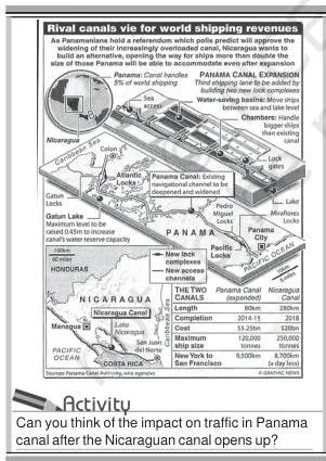
| Locks | None — a sea-level canal | A six-lock system lifting ships 26 m up and down |
| Distance saved | Reduces the sea distance between Liverpool and Colombo | Shortens New York to San Francisco by 13,000 km |
| Extra facts | About 100 ships cross daily; each takes 10-12 hours | Vital to the economies of Latin America |
Suez tolls are so heavy that some ship owners prefer the longer Cape route when delay does not matter.
Inland waterways depend on navigability: the width and depth of the channel, continuity of water flow, and the transport technology in use. Heavy cargo such as coal, cement, timber and metallic ores moves well by river. The named waterways are worth learning as a set:
- Rhine — the world’s most heavily used waterway; navigable for 700 km from Rotterdam to Basel in Switzerland; more than 20,000 ocean-going ships and 2,00,000 inland vessels exchange cargo each year.
- Danube — serves Eastern Europe; rises in the Black Forest and carries wheat, maize, timber and machinery.
- Volga — Russia’s great waterway, 11,200 km navigable, draining into the Caspian Sea; canals link it to Moscow and the Black Sea.
- Great Lakes-St. Lawrence Seaway — the Great Lakes joined by the Soo and Welland canals; goods are trans-shipped to smaller vessels at Montreal because of rapids.
- Mississippi-Ohio — links the interior of the U.S.A. with the Gulf of Mexico; large steamers reach Minneapolis.
Air Transport and Pipelines
Air is the fastest and most costly mode of transport; pipelines are the quiet, continuous workhorse for liquids and gases.
Air transport is preferred by passengers over long distances, moves valuable cargo fast, and is often the only way to reach inaccessible areas — the book’s examples are the Eskimos of Northern Canada and Himalayan routes blocked by landslides and snow. No place in the world is more than about 35 hours away.
The dense inter-continental routes form an east-west belt in the Northern Hemisphere, with the densest networks in Eastern U.S.A., Western Europe and Southeast Asia; the U.S.A. alone accounts for 60 per cent of the world’s airways. Services stay sparse between 10 and 35 degrees south latitude because population, landmass and economic development are limited there.
Pipelines carry water, petroleum, natural gas and liquefied coal with an uninterrupted flow — in New Zealand, milk moves by pipeline from farms to factories. The Big Inch pipeline carries petroleum from the Gulf of Mexico to the north-eastern U.S.A., and about 17 per cent of all U.S. freight per tonne-km moves through pipelines.
The proposed Iran-India via Pakistan pipeline would be the longest in the world.
Communications: From Telegraph to Cyberspace
The second half of the title traces how messages, not goods, became the fastest thing that moves — the half that shrinks the world.
The telegraph and telephone were the early long-distance tools. The telegraph was instrumental in the colonisation of the American West, and the telephone became a factor in the urbanisation of America. The first breakthrough came with optic fibre cables, which send large quantities of data rapidly, securely and virtually error-free.
In the 1990s, digitisation merged telecommunication with computers into integrated networks — the Internet.
Satellite communication emerged after the 1970s, when the U.S.A. and former U.S.S.R. pioneered space research. Its defining property is that the unit cost and time of communication stay invariant with distance — it costs the same to communicate over 500 km as over 5,000 km.
India’s milestones are Aryabhatt (1975), Bhaskar-I (1979), Rohini (1980), APPLE (1981) and INSAT, which made long-distance communication, television and radio effective.
Cyberspace is the electronic digital world for communicating and accessing information over computer networks, without physical movement of sender or receiver. Its growth has been unprecedented: fewer than 50 million users in 1995, about 400 million in 2000, over 2 billion in 2010 and about 5.4 billion in 2023, with the U.S. share falling from 66 per cent in 1995 to 25 per cent in 2005.
Cyberspace expands economic and social space through e-mail, e-commerce, e-learning and e-governance — and the chapter closes with the claim that modern communication, more than transport, has made the global village a reality.
Reading the Chapter’s Maps: Railways, Sea Routes and Canals
Geography chapters are read with the maps open. Each figure below is one the book uses to fix a fact in place — notice what the image shows, and keep that fact attached to the image.

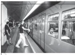
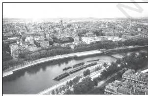
The chapter’s leading image brings all four modes into one frame. Use it as the organising idea — every later map and route belongs to one of these four, and each mode except pipelines carries both passengers and freight.
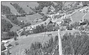
The ropeway photograph belongs to the newer developments in land transport. The line climbs a steep mountain slope — exactly the situation the book describes, where roads cannot be built, so loads move by cable instead.
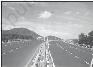
This photograph shows the kind of metalled highway the Highways section describes — divided carriageways built for unobstructed traffic flow. India’s named example in the text is the Golden Quadrilateral joining New Delhi, Mumbai, Chennai and Kolkata.

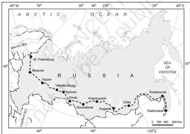
Trace the Trans-Siberian line on the map from St. Petersburg in the west to Vladivostok on the Pacific coast. Its 9,332 km make it the longest double-tracked, electrified trans-continental railway in the world, and the route cities — Moscow, Novosibirsk, Irkutsk — are the junction points the chapter names.
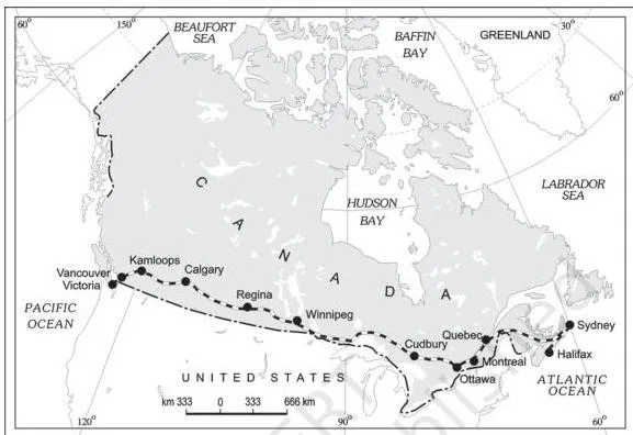
The Trans-Canadian map runs the other way across the continent: Halifax in the east to Vancouver on the west coast, 7,050 km. The book calls it the economic artery of Canada because it links the Quebec-Montreal industrial region with the Prairie wheat belt and the coniferous forest region.
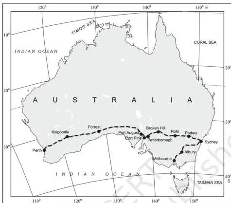
Compare the Australian line with the two above: it runs west-east across the southern part of the continent, Perth to Sydney. A separate north-south line is planned from Adelaide through Alice Springs to link with the Darwin-Birdum line.
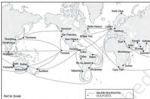
This is the chapter’s most important map — read it until you can name all six routes from memory: the Northern Atlantic (the Big Trunk Route), the Mediterranean-Indian Ocean, the Cape of Good Hope, the Southern Atlantic, the North Pacific and the South Pacific.
Locate the Suez Canal where the Mediterranean meets the Red Sea and the Panama Canal across the isthmus. The Northern Atlantic route is the one carrying about one fourth of the world’s foreign trade.
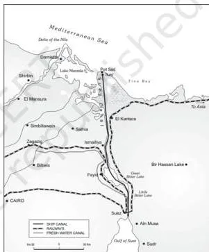
The Suez photograph shows a sea-level canal running through flat terrain — which is exactly why it needs no locks. It links Port Said to Port Suez, about 160 km, and about 100 ships cross it daily.
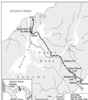
Now compare Panama: the photograph shows the lock staircase, and the chapter gives the number — a six-lock system lifting ships 26 m up and down. This contrast with the lock-free Suez is the fact students most often invert.
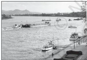
The Rhine image shows why the book calls this the world’s most heavily used waterway — a wide, deep channel navigable for 700 km from Rotterdam to Basel, with more than 20,000 ocean-going ships and 2,00,000 inland vessels exchanging cargo each year.
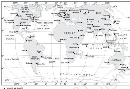
The airports map marks the nodal points — New York, London, Paris, Singapore, Tokyo and others on the same belt — where inter-continental routes converge. The dense networks sit in Eastern U.S.A., Western Europe and Southeast Asia, and the U.S.A. alone accounts for 60 per cent of world airways.
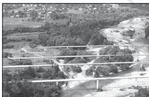
The pipelines photograph shows gas pipelines crossing open country — the chapter’s point that pipelines are land routes for liquids and gases with an uninterrupted flow. The American example to attach here is the Big Inch, carrying petroleum from the Gulf of Mexico to the north-eastern U.S.A.
Try it with the atlas: find some of the important ports on the coast of the U.S.A. and Western Europe. This is the chapter’s own activity, and it practises exactly the map-reading the sea-route section expects.
Definitions: The Terms the Chapter Uses
This is a lookup table for the terms the book uses, gathered into one place for quick revision.
| Term | Plain meaning | Where it matters |
|---|---|---|
| Transport | A service for carrying people and goods from one place to another, using humans, animals or vehicles | The chapter’s opening definition; everything else builds on it |
| Transport network | Several places (nodes) joined by a series of routes (links) to form a pattern | The chapter’s single structural model |
| Road density | Length of road per unit of area | North America has the highest; it holds 33 per cent of the world’s 15 million km of motorable roads |
| Border roads | Roads laid along international boundaries | Integrate remote areas with major cities and serve defence |
| Trans-continental railway | A rail line running across a continent and linking its two ends | The five named lines: Trans-Siberian, Trans-Canadian, Union and Pacific, Australian, Orient Express |
| Big Trunk Route | The Northern Atlantic Sea Route, the busiest in the world | Carries about one fourth of the world’s foreign trade |
| Coastal shipping | Moving goods by sea between a country’s own coastal ports | Convenient for long coastlines such as the U.S.A., China and India |
| Navigability | The quality that makes a river usable for shipping | Depends on width and depth of channel, continuous flow, and transport technology |
| Inland waterways | Rivers, canals, lakes and coastal stretches used for transport | Rhine, Danube, Volga, Great Lakes-St. Lawrence, Mississippi-Ohio |
| Satellite communication | Communication through artificial satellites in the earth’s orbit | Unit cost and time stay the same whatever the distance |
| Cyberspace | The electronic digital world of the Internet, used without physical movement | Expands economic and social space through e-mail, e-commerce, e-learning, e-governance |
| Global village | The idea that modern communication, more than transport, has drawn the world together | The chapter’s closing claim |
Common Mistakes in This Chapter and the Corrections
This chapter rewards exact recall, so its classic errors are route mix-ups and inverted facts. Five of the multiple-choice traps sit in this list — fix them once and they stay fixed.
| Mistake | Correct fact | Quick check |
|---|---|---|
| The Stuart Highway runs between Edmonton and Anchorage | The Stuart Highway runs between Darwin and Melbourne; Edmonton-Anchorage is the Alaskan Highway, and Vancouver-St. John’s City is the Trans-Canadian Highway | Stuart is Australian — remember Darwin and Melbourne |
| The Trans-Canadian Railway runs from Vancouver to Halifax | The railway runs from Halifax (east) to Vancouver (west coast); the Trans-Canadian Highway runs the other way, Vancouver to St. John’s City | Railway: Halifax to Vancouver; Highway: Vancouver to St. John’s |
| The highest railway density is in Russia or the U.S.A. | Belgium has the highest density — 1 km of railway for every 6.5 sq km | A small European country; the fact is Belgium’s, not a giant nation’s |
| The Big Trunk Route runs through the Mediterranean or the Pacific | The Big Trunk Route is the Northern Atlantic Sea Route | It links north-eastern U.S.A. with north-western Europe and carries one fourth of world foreign trade |
| The Big Inch pipeline transports milk, LPG or water | The Big Inch transports petroleum, from the Gulf of Mexico to the north-eastern U.S.A. | Milk by pipeline is the New Zealand example, not the Big Inch |
| The Channel Tunnel links London and Berlin | The Channel Tunnel links London and Paris | Both cities are on the same side of the English Channel crossing |
| Suez has locks; Panama is sea-level | It is the reverse: Suez is a sea-level canal without locks (about 160 km); Panama has a six-lock system lifting ships 26 m (about 72 km) | Suez is flat desert terrain; Panama crosses a raised isthmus |
| The Danube is the most heavily used waterway and the Rhine serves Eastern Europe | The Rhine is the world’s most heavily used waterway, navigable 700 km to Basel; the Danube serves Eastern Europe and rises in the Black Forest | Rhine: western industrial heartland; Danube: eastern Europe |
| Air suits bulky goods; water suits perishable goods | Water is cheapest for bulky goods over long distances between continents; air is for high-value, light and perishable goods | Think cost per tonne: heavy and slow belongs to ships, light and fast to planes |
Exam Notes: What the Chapter’s Exercises Actually Test
The chapter closes with a short exercise block split into Question 1 (multiple choice), Question 2 (about 30 words) and Question 3 (up to 150 words). Each tests a different kind of recall, so aim your revision accordingly.
| Exercise | What it tests | Where the answer sits in the chapter |
|---|---|---|
| Question 1 — multiple choice | Memorised route facts: Stuart Highway endpoints, highest railway density, Big Trunk Route ocean, Big Inch cargo, Channel Tunnel pair | Highways, Railways, Sea Routes and Pipelines sections |
| Question 2 — about 30 words | Three short items: problems of road transport in mountainous, desert and flood-prone regions; the definition of a trans-continental railway; the advantages of water transport | Roads, Trans-Continental Railways, Water Transport sections |
| Question 3 — not more than 150 words | The three big ideas: how modes complement each other; the regions with dense air networks; how cyberspace expands economic and social space | Modes of Transportation, Inter-Continental Air Routes, Cyber Space-Internet sections |
What a full-marks answer includes, by question:
- Question 1: the exact named fact — the correct endpoints, the correct ocean, the correct cargo, the correct city pair. There is no room for a near-miss.
- Question 2: three or four crisp points in 30 words; a trans-continental railway defined in a single sentence; water transport’s advantages listed — no route construction, low friction, cheapest haulage for bulky goods.
- Question 3(i): each mode matched to its best job, ending with the statement that modes complement each other; (ii) the dense regions named — Eastern U.S.A., Western Europe, Southeast Asia, with the U.S.A.’s 60 per cent share; (iii) the four modes of expansion — e-mail, e-commerce, e-learning and e-governance.
The chapter’s atlas activity — finding important ports on the coasts of the U.S.A. and Western Europe — is the map-reading skill to practise alongside the sea routes.
Textbook contents and the examinable syllabus are not always identical — check the current official CBSE syllabus for the portion you are expected to study. No particular question is guaranteed to appear.
Quick Revision: The Whole Chapter on One Screen
Everything the night before a test needs — the chapter’s argument, its modes, and the numbers that keep coming back.
The argument: resources, activities and markets are rarely found in one place; transport, communication and trade link producing with consuming centres; efficient transport raises living standards.
The modes and their jobs:
- Land — roads for short distances and door-to-door service; railways for bulky goods over long distances; pack animals, highways and border roads complete the picture.
- Water — the cheapest carriage for bulky goods between continents; six sea routes, the Suez and Panama canals, and five named inland waterways.
- Air — fastest and costliest; long-distance passengers, valuable cargo, and access to areas nothing else reaches.
- Pipelines — liquids and gases with uninterrupted flow; the Big Inch, 17 per cent of U.S. freight, and the proposed Iran-India via Pakistan line.
| Named route or waterway | Key facts to hold |
|---|---|
| Trans-Siberian Railway | Longest trans-continental line: 9,332 km, St. Petersburg to Vladivostok |
| Trans-Canadian Railway | 7,050 km, Halifax to Vancouver; the economic artery of Canada |
| Suez Canal | Opened 1869, about 160 km, sea-level, no locks |
| Panama Canal | About 72 km, six locks, 26 m lift; saves 13,000 km between New York and San Francisco |
| Rhine | The world’s most heavily used waterway; navigable 700 km to Basel |
| Big Inch | Petroleum pipeline from the Gulf of Mexico to the north-eastern U.S.A. |
The communications sequence: telegraph and telephone → optic fibre cables → satellites from the 1970s → cyberspace and the Internet. The chapter’s closing idea: modern communication, more than transport, has made the global village a reality.
Related Resources
This listing is maintained for the 2026-27 academic session using the NCERT textbook information available to us. NCERT remains the authority for confirming the latest edition.
Read this chapter in context with the rest of Class 12 Geography — the previous chapter covers manufacturing, and the next one covers trade.
- Class 12 Geography notes hub — every geography chapter on one page.
- The next chapter, International Trade, continues the trade theme this chapter opens with.
- Other Class 12 Geography material includes Planning and Sustainable Development in the Indian Context.
- Class 12 CBSE notes — all subjects on one hub.
- The full CBSE notes index, if you are preparing across classes.
Reference: NCERT Class 12 Geography textbook, chapter 7, official edition on ncert.nic.in.
Sources and Data Verification
The facts on this page describe the NCERT Class 12 Geography textbook Fundamentals of Human Geography, Chapter 7, Transport and Communication, from the official NCERT edition and PDF.
This page covers this one chapter only — not the book’s other chapters and not the whole syllabus. It is maintained for the current academic session using the NCERT information available to us.
The book’s printed page numbers were not independently verified, so this page refers to sections by name rather than by page number. NCERT settles textbooks, editions and PDFs; CBSE settles the curriculum, syllabus and examinations.
FAQs: Transport and Communication Class 12 Quick Answers
Which is the longest trans-continental railway in the world?
The Trans-Siberian Railway. It runs 9,332 km from St. Petersburg to Vladivostok and is the longest double-tracked, electrified trans-continental railway in the world.
Why is the Northern Atlantic Sea Route called the Big Trunk Route?
Because it carries more foreign trade than any other route. It links north-eastern U.S.A. with north-western Europe, the two most industrially developed regions, and moves about one fourth of the world’s foreign trade.
What is the difference between the Suez Canal and the Panama Canal?
Suez, opened in 1869 and about 160 km long, is a sea-level canal with no locks linking the Mediterranean and the Red Sea. Panama, about 72 km long, uses a six-lock system that lifts ships 26 m, links the Atlantic and Pacific, and shortens New York to San Francisco by 13,000 km.
Which is the world’s most heavily used inland waterway?
The Rhine. It is navigable for 700 km from Rotterdam to Basel, and each year more than 20,000 ocean-going ships and 2,00,000 inland vessels exchange cargo on it.
What is a transport network in geography?
Several places (the nodes) joined by a series of routes (the links) to form a pattern. The map of cities and the roads between them is a transport network.
Which areas of the world have the densest air transport networks?
Eastern U.S.A., Western Europe and Southeast Asia, lying in an east-west belt of inter-continental routes in the Northern Hemisphere. The U.S.A. alone accounts for about 60 per cent of the world’s airways.
Explore Class 12 Geography Books
Related chapters: