
This is the NCERT Class 12 Geography Chapter 9, Geographical Perspective on Selected Issues and Problems, from the book India: People and Economy. The geographical perspective on selected issues and class 12 Geography takes in environmental pollution, urban waste disposal, rural-urban migration, slums and land degradation, each tied to a named place in India.
The official NCERT PDF of this chapter is right below, and the rest of the page explains what the chapter teaches.
Download the NCERT Class 12 Geography Chapter 9 PDF
The file below is the official NCERT edition of Chapter 9 from India: People and Economy — 11 printed pages on pollution, waste, migration, slums and land degradation, hosted on the ncert.nic.in website, the same edition your school follows.
Open the NCERT Class 12 Geography Chapter 9 Geographical Perspective on Selected Issues and Problems PDF to read the chapter exactly as NCERT published it, with all its tables, photographs and exercise questions. The file opens on the official NCERT site, so it is always the current edition.
| What the chapter holds | Count | Where it is used |
|---|---|---|
| Printed pages | 11 | |
| Figures with NCERT captions | 15 | |
| Tables | 2 | |
| Exercise questions | 3 | answered in our NCERT Solutions |
| Activities | 1 | |
| Official NCERT PDF | Download the chapter PDF | the chapter exactly as NCERT publishes it |
Chapter 9 at a Glance
The chapter summary table on this page lists the exact totals for its sections, figures and exercises. Here are the landmarks worth knowing by name.
- It opens with environmental pollution and its four classes — air, water, land and noise — classified by the medium that carries the pollutants.
- It carries two data tables: Table 9.1 Types and Sources of Pollution and Table 9.2 Sources of Pollution in the Ganga and the Yamuna Rivers.
- It uses five numbered photographs, Figs 9.1 to 9.5, as location-specific evidence.
- It contains three case studies — Daurala, Ramesh and Jhabua — each one a model for understanding or solving a problem.
- It includes one activity on urban waste, built around a photograph of Mahim in Mumbai.
- It closes with three exercises: multiple-choice questions, short answers of about 30 words, and long answers of about 150 words.
What This Chapter Covers: Pollution, Waste, Migration and Land
The chapter studies India’s environmental and urban problems from a geographical perspective — as problems located in specific places, not as abstract science. Each problem is built the same way: a definition, a table of sources, a photograph, and often a case study.
- Environmental pollution — the organising definition and the four classes.
- Urban waste disposal — where city waste goes and what it does to people and rivers.
- Rural-urban migration — why people move and what they find at the destination.
- Problems of slums — how poverty becomes a place in the city.
- Land degradation — how rural land loses its productive capacity.
Notice the method: the chapter names the Ganga and the Yamuna, a waste pile in Mahim, a migrant called Ramesh, and the Jhabua district, so every generalisation is anchored to a real place.
Key Concepts in the Chapter
Each topic below opens with what the idea is and why the chapter cares about it, then gives the detail you need for exam answers.
Environmental Pollution and Its Classification
Geographers study pollution as an environmental problem created by the waste products of human activity. The chapter sorts its many forms by the medium — air, water or land — that carries the pollutants.
Environmental pollution results when waste products of human activities release substances and energy into the environment. Because pollutants travel through different media, pollution is classified into four types: air pollution, water pollution, land pollution and noise pollution.
| Pollution type | Main pollutants named in Table 9.1 | Typical sources named in Table 9.1 |
|---|---|---|
| Air | Oxides of sulphur and nitrogen, carbon monoxide, hydrocarbons, ammonia, lead, asbestos | Combustion of coal, petrol and diesel; industrial processes; solid waste and sewage disposal |
| Water | Dissolved and suspended solids, ammonia and urea, nitrates, oil and grease, pesticide residues, heavy metals, radioactive substances | Sewage disposal, urban run-off, toxic effluents from industries, run-off over cultivated lands, nuclear power plants |
| Land | Human and animal excreta, viruses and bacteria, garbage, pesticide and fertiliser residues | Improper human activities, disposal of untreated industrial waste, use of pesticides and fertilisers |
| Noise | High levels of sound above tolerance level | Aircraft, automobiles, trains, industrial processing, advertising media |
Hold on to the word ‘pollutants’ — the difference between pollution and pollutants is tested directly in Exercise 2(i) and settled in the definitions section below.
Water Pollution and the Ganga and Yamuna
Water pollution gets the most space because everyone uses water, and rivers carry every kind of waste downstream to someone else’s tap.
Surface water from rivers, canals and lakes is never pure. It naturally contains small quantities of suspended particles and organic and inorganic substances. Water becomes polluted when the concentration of these substances rises so high that the water’s self-purifying capacity can no longer clean it.
Pollutants also come from natural sources, like erosion and the decay of plants and animals, but human activities are the real concern. The chapter names industrial, agricultural and cultural activities, with industry the most significant contributor.
Industry releases industrial wastes, polluted waste water, poisonous gases, chemical residues and heavy metals into running water, destroying its bio-system. The major water-polluting industries named are leather, pulp and paper, textiles and chemicals.
Modern agriculture adds inorganic fertilisers, pesticides and herbicides. These wash into rivers, lakes and tanks and infiltrate the soil to reach groundwater, and fertilisers raise the nitrate content of surface waters. Cultural activities — pilgrimage, religious fairs and tourism — add to the contamination.
The health cost is direct: contaminated water causes diarrhoea, intestinal worms and hepatitis. The World Health Organization, the chapter reports, finds about one-fourth of the communicable diseases in India are water-borne.
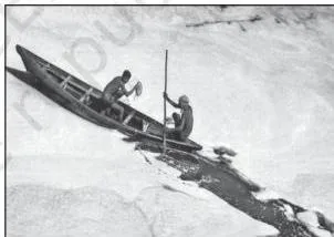
The photograph above is the chapter’s first piece of field evidence. It shows people rowing through a pervasive layer of foam on the heavily polluted Yamuna on the outskirts of New Delhi — the very river the chapter’s table names as Delhi’s dumping ground.
Table 9.2 pins the pollution to exact stretches. On the Ganga, the polluted stretches lie downstream of Kanpur and Varanasi and at the Farakka Barrage: industrial pollution from towns like Kanpur, domestic wastes from urban centres and the dumping of carcasses are the causes, with Kanpur, Prayagraj, Varanasi, Patna and Kolkata releasing domestic waste into the river.
On the Yamuna, the polluted stretches run from Delhi to its confluence with the Chambal, and at Mathura-Agra. The causes: Haryana and Uttar Pradesh extracting water for irrigation, agricultural run-off carrying high levels of micro-pollutants, and Delhi’s domestic and industrial waste flowing into the river.
Air Pollution, Smog and Acid Rain
Air pollution is the one form that travels — it crosses neighbourhoods and even countries — and it attacks the respiratory, nervous and circulatory systems.
Air pollution means putting contaminants into the air — dust, fumes, gas, fog, odour, smoke or vapour — in substantial proportion and for enough duration that flora, fauna and property can be harmed. Combustion of fossil fuels, mining and industries are the main sources, releasing oxides of sulphur and nitrogen, hydrocarbons, carbon dioxide, carbon monoxide, lead and asbestos.
Two visible effects follow. Urban smog — smoky fog over cities — is caused by atmospheric pollution and proves very harmful to human health. Air pollution can also cause acid rain: rainwater analysis of urban environments shows the pH of the first rain after summer is always lower than subsequent rains.
Two WHO reports are printed in the chapter. One calls air pollution the world’s biggest environmental health risk, causing at least one in eight deaths globally. The other counts about 300,000 deaths a year in major Southeast Asian and Chinese cities, and some 400,000 worldwide.
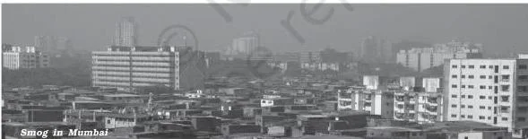
The image above is the chapter’s way of showing the health pathway the whole section relies on: air pollution causes various diseases related to respiratory, nervous and circulatory systems. Read it as the bridge between the definition of air pollution and the WHO death figures.
The Namami Gange Programme
After the water section shows why the Ganga worries India, the chapter answers with the government’s flagship cleaning programme.
Because the Ganga flows through one of the most populous regions of India, its pollution has caused great concern. The National Mission for Clean Ganga was initiated first, and the Union Government has launched the Namami Gange Programme for the same purpose — cleaning the river by effectively controlling its pollution.
The seven objectives fall into three groups of river-cleaning actions:
- Cleaning the water itself: developing sewerage treatment systems in towns, monitoring industrial effluents, and cleaning the river surface.
- Greening and beautifying: developing the river front, and afforestation along the banks to increase biodiversity.
- People and awareness: developing ‘Ganga Grams’ in Uttarakhand, Uttar Pradesh, Bihar, Jharkhand and West Bengal, and creating public awareness so people avoid adding pollutants to the river even in the form of rituals.
Noise Pollution and Its Sources
Noise has a distinctly geographical property — it is location-specific, and its intensity declines with distance from the source.
Noise pollution is a state of unbearable and uncomfortable noise caused by different sources, measured in decibels. It has become a serious concern only in recent years, with a variety of technological innovations.
The main sources are factories, mechanised construction and demolition works, automobiles and aircraft. There is added periodical noise from sirens and loudspeakers used in festivals and community activities.
Traffic is the biggest nuisance because its intensity and nature depend on the type of aircraft, vehicle or train, and on the condition of the road and vehicle. In sea traffic, noise is confined to the harbour. Industries vary in intensity, and the problem is hazardous in many metropolitan and big cities in India.
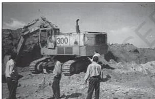
The photograph above shows noise monitoring at Panchpatmalai Bauxite Mine — an instrument being used on site. That is the geographical point in one image: noise pollution is a placed, measurable problem that can be surveyed like any other.
A ‘Do you know’ box reports a Scripps Institute study of declassified US Navy documents: ocean noise has increased tenfold since the 1960s. Levels in 2003-2004 were about 10 to 12 decibels higher than in 1964-1966, attributed to the growth in global shipping, more ships plying the oceans and higher vessel speeds.
Urban Waste Disposal and the Daurala Case
Cities generate waste faster than they can remove it, and the chapter asks what that waste does to people and rivers.
Solid waste means old and used articles — stained pieces of metal, broken glassware, plastic containers, polythene bags, ash, floppies and CDs — dumped at different places. These are also termed refuse, garbage and rubbish, and come from two sources: household or domestic establishments, and industrial or commercial establishments.
Household wastes are disposed of on public lands or private contractors’ sites. Industrial wastes are collected through municipal facilities at low-lying public grounds, the landfill areas. A huge turnout of ashes and debris comes from industries, thermal power houses and building construction or demolition.
Solid wastes create health hazards through obnoxious smell and by harbouring flies and rodents, which carry diseases like typhoid, diphtheria, diarrhoea, malaria and cholera. Wastes are spread by wind, splattered by rain water, and untreated wastes ferment slowly, releasing toxic biogas including methane.
The disposal gap is the chapter’s key statistic. In metropolitan cities like Mumbai, Kolkata, Chennai and Bengaluru, about 90 per cent of solid waste is collected and disposed of.
But in most other cities and towns, 30 to 50 per cent of the waste generated is left uncollected on streets and open spaces. The chapter argues such wastes should be treated as a resource for generating energy and compost.

The three photographs below move from general to particular. The first shows the overcrowding, congestion and poor sanitary conditions that mark urban areas and make waste disposal a daily crisis.
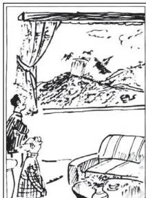
The second photographs the chapter’s own headline statement — urban waste disposal is a serious problem in India — in a pile of mixed waste no municipal service has cleared.
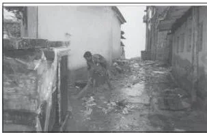
The third, Figure 9.3, is a view of urban waste in Mahim, Mumbai. It is the photograph the chapter’s Activity points back to when it asks where your waste ends up.
The Activity asks four questions about your own household: What do we throw away? Why? Where does our waste end up? Why do ragpickers sort out rubbish dumps — does it have some value? Is our urban waste worth anything? The Mahim photograph is the prompt: waste is visible, located matter, not an abstraction.
The Daurala case study is the chapter’s worked answer. Daurala, near Meerut, had its groundwater contaminated with heavy metals because the untreated wastewater of local industries was leaching into the groundwater table.
Following the universal law ‘polluter pays’, a Meerut-based NGO, the village community, people’s representatives and the industrialists together found sustainable solutions. The overhead water tank’s capacity was enhanced and a 900 m extra pipeline was laid for potable water. The silted village pond was desilted and cleaned so it could recharge the aquifers.
Rainwater harvesting structures were built, diluting groundwater contaminants after the monsoons, and 1,000 trees were planted.
The efforts began in 2003, when the pitiable condition of the villagers drew the attention of civil society. They have brought a new lease of life to the twelve thousand residents, and the chapter calls the result a role model for restoring ecology and safeguarding human health with people’s participation.
Rural Urban Migration: The Ramesh Case Study
Urban growth is partly a story of people moving, and Ramesh’s case study turns that process into a chain of decisions one family made.
Population flow from rural to urban areas is caused by high demand for labour in urban areas, low job opportunities in rural areas, and an unbalanced pattern of development between the two. Because smaller and medium cities offer few opportunities, poor people generally bypass them and go directly to mega cities.
Ramesh works as a contract welder and has moved with the same contractor to places like Surat, Mumbai, Gandhinagar, Bharuch and Jamnagar. He remits about Rs 20,000 per year to his father, used for daily consumption, healthcare and schooling of children, with part going into agriculture, land and house construction. The family’s standard of living has improved significantly.
Fifteen years ago the family was very different: three brothers and their families survived on three acres of land, the family was heavily in debt, and Ramesh had to discontinue his studies after the ninth standard.
Impressed by successful out-migrants working in Ludhiana, and pushed by abject poverty, he moved to Punjab with a friend and worked in a woollen factory at Rs 20 per day in 1988. Later, under his friend’s guidance, he moved to Surat, learnt welding, and has since travelled between cities with the same contractor.
Though the family’s economic condition improved, Ramesh bears the pain of separation from his near and dear ones. He cannot shift them with him, because the job is temporary and transferable.
The story separates cleanly into push and pull factors. Push — abject poverty, heavy debt, three acres for three families, low rural opportunity. Pull — perceived job promises at Ludhiana, the visible success of village out-migrants, and urban demand for labour. Exercise 1(iv) tests exactly this pairing.
A ‘Do you know’ box adds the global frame: 55 per cent of the world’s population lives in cities, estimated to reach 68 per cent by 2050. Urban population grows through natural increase, net in-migration, and reclassification of urban areas.
Since 1961, about 29 per cent of India’s urban growth has come from rural-to-urban migration. The larger share is attributed to natural increase — an easy point to forget when migration dominates the discussion.
The chapter’s ‘Comments’ paragraph draws the conclusion: poor, semi-literate and unskilled migrants like Ramesh end up in menial, low-wage jobs in the informal sector. With wages too low to support a family at the destination, spouses stay behind to care for children and the elderly — so the rural-urban migration stream is dominated by males.
Problems of Slums and the Dharavi Extract
Slums are the urban extreme of poverty. The chapter contrasts them with high-income localities to show that Indian cities are sharply divided spaces.
India has a predominance of rural population — approximately 69 per cent of the total in 2011 — and most villages exist as the hinterland, an appendix to core urban centres. Yet urban centres are more differentiated in socio-economic terms than any other area.
At one end stand farm houses and high-income localities with wide roads, streetlights, water and sanitation, lawns, a green belt, parks, playgrounds and provisions for security and privacy. At the other extreme are the slums, jhuggi-jhopari clusters and colonies of shanty structures.
Slums are inhabited by people who migrated to urban centres for livelihood but could not afford proper housing because of high rent and high costs of land, so they occupy environmentally incompatible and degraded areas.
The chapter’s definition: slums are residential areas of the least choice, with dilapidated houses, poor hygienic conditions, poor ventilation and lack of basic amenities like drinking water, light and toilet facilities. Open defecation, unregulated drainage and overcrowded narrow streets are serious health and socio-environmental hazards.
The Swachh Bharat Mission is part of the urban renewal mission launched by the Government of India to improve the quality of life in urban slums.
Most slum workers are employed in low-paid, high-risk, unorganised sectors. They are undernourished, prone to disease, cannot afford proper education for their children, and are vulnerable to drug abuse, alcoholism, crime, vandalism and social exclusion.
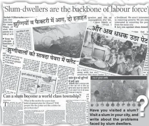
Two photographs anchor this section. The first is the chapter’s bridge from the rural-urban divide: both urban and rural settlements are different in their functions. The second is the famous Dharavi lane — the visual core of the section.
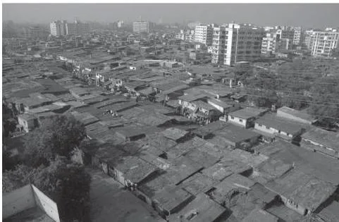
The second photograph shows what a slum’s crowding looks like from inside: only one main road traverses Dharavi, the miscalled ‘ninety-foot road’, reduced to less than half that width for most of its length, with alleys so narrow that not even a bicycle can pass.
Dharavi — Asia’s largest slum — is described through a 1996 account by Jeremy Seabrook that the chapter quotes at length. Buses merely skirt its periphery; a single room is rented by a whole family, sometimes accommodating twelve or more people; uncollected garbage and stagnant pools of foul water sit everywhere.
But the same place produces some of the most valued articles in India: delicate ceramics and pottery, embroidery and zari work, sophisticated leather goods, high-fashion garments, finely-wrought metalwork, jewellery settings and wood carvings, destined for the richest houses in India and abroad. Dharavi was built on waste filling an arm of the sea.
Land Degradation and the Jhabua Watershed Case
The chapter’s last problem is rural. Land loses its productive capacity through misuse, and the Jhabua case study shows how a community can reverse that.
Land degradation means a temporary or permanent decline in the productive capacity of the land. It is induced by soil erosion, waterlogging, salinisation and alkalinisation, and by consistently using land without managing its fertility.
The chapter’s central distinction: not every piece of degraded land is already wasteland, but degradation left unchecked converts land into wasteland. The National Remote Sensing Centre has classified wastelands by remote sensing, and the creating processes fall into three groups:
- Primarily natural agents: gullied or ravinous land, desertic or coastal sands, barren rocky areas, steep sloping land, and glacial areas.
- Natural as well as human factors: waterlogged and marshy areas, land affected by salinity and alkalinity, and land with or without scrub.
- Human action: degraded shifting cultivation areas, degraded land under plantation crops, degraded forests, degraded pastures, and mining and industrial wastelands.
The chapter’s finding is that man-made wastelands are more important than natural ones — which is why the case study that follows is about a community fixing damage it partly caused.
Jhabua district lies in the westernmost agro-climatic zone of Madhya Pradesh and is one of the five most backward districts of the country, with a high concentration of tribal population, mostly Bhils. Poverty is accentuated by high rates of forest and land degradation.
Watershed management programmes funded by the Ministries of Rural Development and Agriculture have succeeded in Jhabua because they acknowledge the linkage between land, water and vegetation. The Rajiv Gandhi Mission for Watershed Management — with Ministry of Rural Development funding alone — treated 20 per cent of the district’s total area in five years.
In Petlawad block, the Bhils of Sat Rundi hamlet of Karravat village revitalised large parts of common property resources. Each household planted and maintained one tree on the common property, planted fodder grass on pasture land, adopted social fencing for at least two years, and planned stall feeding of cattle instead of open grazing.
One conflict shows the method. A villager from an adjoining village had encroached on the common land; the villagers called the tehsildar to ascertain its rights, then made the defaulter a member of their user group and shared the benefits of greening the commons. The chapter cross-references its chapter ‘Land Resources and Agriculture’ for common property resources.
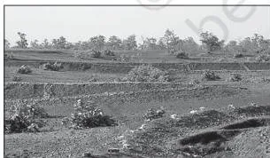
The two photographs below are the chapter’s proof that community participation, not state action alone, restored degraded common land. Figure 9.4 shows trees planted on common property resources in Jhabua — one per household, as the case study describes.
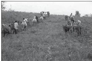
Figure 9.5 shows the same community at work — community participation for land leveling in common property resources in Jhabua. Together the two images document the sequence the text narrates: planting, fencing, and shared management of the commons.
Reading the Chapter’s Photographs


The photographs are all shown above in their sections, so use the figure numbers to scroll back. The point worth understanding: every photograph in this chapter is location-specific evidence, and that is exactly what makes the chapter geographical rather than a general science lesson.
- Figure 9.1 (water): people rowing through a layer of foam on the Yamuna at the outskirts of New Delhi. The foam is the visible form of the domestic and industrial waste the table attributes to Delhi — the photo proves Table 9.2 without a word.
- Air pollution image: the human body under attack. The three target systems — respiratory, nervous and circulatory — form the pathway between contaminated air and the WHO death figures.
- Figure 9.2 (noise): noise monitoring at Panchpatmalai Bauxite Mine. An instrument, a person, a specific site: noise pollution is measurable and location-specific, exactly as the text argues.
- Figure 9.3 (waste): a view of urban waste in Mahim, Mumbai. The waste sits in a named locality of a metro city, answering the Activity’s question about where our waste ends up.
- The Dharavi ‘ninety-foot road’ (slums): the road reduced to less than half its width, alleys too narrow for a bicycle — the physical crowding behind the definition of a slum.
- Figures 9.4 and 9.5 (land): trees planted and land leveled on common property resources in Jhabua. The work is done by villagers themselves — community participation made visible.
Notice the sequence: water, air, noise, waste, slums, land. Each photograph pins a generalisation to a named place — a river, a mine, a Mumbai locality, a slum, a district.
Key Definitions from the Chapter
Exam answers in this chapter are won by using the book’s terms precisely. These are the terms, in plain words, ordered the way the chapter introduces them.
| Term | Plain definition | Why it matters |
|---|---|---|
| Environmental pollution | The release of substances and energy from the waste products of human activities. | The chapter’s organising definition; every later type is a form of it. |
| Pollutants | The individual substances released — oxides of sulphur, lead, ammonia, pesticide residues and the rest. | Pollution is the process; pollutants are the materials. Exercise 2(i) asks for this difference. |
| Air pollution | Adding contaminants — dust, fumes, gas, fog, odour, smoke or vapour — to the air in substantial proportion and duration, harming flora, fauna and property. | The first of the four classes, defined by its medium. |
| Urban smog | Smoky fog over cities, caused by atmospheric pollution. | A visible effect of air pollution, not natural fog. |
| Noise pollution | A state of unbearable and uncomfortable noise from various sources, measured in decibels. | Location-specific — intensity declines with distance from the source. |
| Solid waste | Old and used articles — metal pieces, broken glass, plastic, polythene, ash, floppies and CDs — also called refuse, garbage and rubbish. | The subject of urban waste disposal and of the Daurala case. |
| Land degradation | A temporary or permanent decline in the productive capacity of the land. | Caused by soil erosion, waterlogging, salinity and unmanaged fertility. |
| Wasteland | Land that unchecked degradation has converted into waste. | Not all degraded land is wasteland — the distinction is examinable. |
| Slums | Residential areas of least choice, with dilapidated houses, poor hygiene, poor ventilation and no basic amenities. | The urban extreme of poverty, inhabited by migrants who could not afford housing. |
Common Mistakes to Avoid in This Chapter
The mistakes students make in this chapter come from treating its terms loosely. Each row names the mistake before you make it, with the correction drawn from the chapter.
| Mistake | Correct rule | How to check your answer |
|---|---|---|
| Writing that pollution and pollutants are the same thing | Pollution is the release of substances and energy from waste products of human activities; pollutants are the actual substances released. | Define pollution first, then name the substances from Table 9.1 as pollutants — that structure answers Exercise 2(i). |
| Saying any impurity makes water polluted | Natural surface water carries suspended particles and organic and inorganic substances; pollution arises when the concentration exceeds the water’s self-purifying capacity. | Quote the self-purifying capacity point when you define water pollution. |
| Calling urban smog natural fog | Urban smog is smoky fog over cities caused by atmospheric pollution. | End your air-pollution answer with smog and acid rain as its two visible effects. |
| Blaming acid rain on water pollution | Acid rain is an effect of air pollution; the first rain after summer has a lower pH than subsequent rains. | Exercise 1(iii) tests exactly this — the cause is air pollution. |
| Treating degraded land and wasteland as the same | All degraded land may not be wasteland, but unchecked degradation may convert it. | Use both statements together when you define either term. |
| Equating urban growth with migration | Urban population grows by natural increase, net in-migration and reclassification of urban areas. | The ‘do you know’ box gives three sources; migration is only one. |
| Reading the case studies as stories | Each carries a model: Daurala = polluter pays with restoration; Ramesh = push and pull factors; Jhabua = community participation in watershed management. | When a question mentions a case, answer with the model it demonstrates. |
| Forgetting noise pollution is location-specific | Its intensity declines with distance from the source. | Say this when you define noise pollution — it is the geographical point. |
Exam Notes: What the Exercises Test
The three exercises at the end of the chapter map one-to-one onto its sections, so this map tells you what to revise for each. Textbook contents and the examinable syllabus are not always identical — check the current official CBSE syllabus before you plan revision.
Multiple Choice Questions: Exercise 1
- (i) The highly polluted river — the Yamuna, from Table 9.2’s Delhi-to-Chambal stretch.
- (ii) The disease caused by water pollution — diarrhoea, from the chapter’s water-borne diseases list.
- (iii) The cause of acid rain — air pollution, from the air pollution section.
- (iv) What push and pull factors are responsible for — migration, from the rural-urban migration section and Ramesh’s story.
Short Answers of About 30 Words: Exercise 2
- (i) Pollution vs pollutants — define environmental pollution, then name pollutants as the substances released.
- (ii) Major sources of air pollution — combustion of fossil fuels, mining and industries, with the gases they release.
- (iii) Major problems of urban waste disposal — uncollected waste in most cities, health hazards from flies and rodents, toxic biogas from untreated waste.
- (iv) Effects of air pollution on human health — diseases of the respiratory, nervous and circulatory systems, plus the WHO figures.
Long Answers of About 150 Words: Exercise 3
- (i) Nature of water pollution in India — self-purifying capacity, industrial-agricultural-cultural sources, and the Ganga-Yamuna stretches from Table 9.2.
- (ii) The problem of slums in India — features, causes, the Dharavi portrait, and the Swachh Bharat Mission.
- (iii) Measures for reduction of land degradation — the Jhabua watershed measures: afforestation, fodder grass, social fencing, stall feeding and community conflict resolution.
The length tells you the shape. A 30-word answer lifts one definition or one list straight from a section and states it cleanly. A 150-word answer needs a short structure: define the problem, give its causes, name an example from the chapter, and end with a measure or a consequence.
Chapter 9 Recap: The Core Ideas in Brief
This chapter has no printed summary section, so here is the chapter rebuilt from its own flow, row by row.
| Issue | What the chapter says | Example from the chapter |
|---|---|---|
| Environmental pollution | Release of substances and energy from waste products of human activities; four classes by medium of transport. | Air, water, land and noise pollution. |
| Water pollution | Concentration of substances rises beyond the water’s self-purifying capacity. | Ganga and Yamuna stretches in Table 9.2; diarrhoea and hepatitis. |
| Air pollution | Contaminants added in substantial proportion and duration, harmful to flora, fauna and property. | Urban smog and acid rain; WHO’s at least one in eight deaths. |
| Noise pollution | Unbearable noise measured in decibels; location-specific with intensity declining by distance. | Traffic as the biggest nuisance; Panchpatmalai monitoring. |
| Urban waste disposal | Metros collect about 90 per cent; most other cities leave 30 to 50 per cent uncollected; waste should be a resource. | Mahim waste photograph; Daurala restoration on the ‘polluter pays’ principle. |
| Rural-urban migration | Push and pull factors; stream dominated by males; remittances improve village life. | Ramesh’s move from Talcher to Ludhiana to Surat. |
| Problems of slums | Least-choice housing in degraded areas, without basic amenities; informal low-wage work. | Dharavi’s ‘ninety-foot road’ and its craft production. |
| Land degradation | Temporary or permanent decline in productive capacity; unchecked degradation becomes wasteland. | Jhabua’s watershed management and common-property greening. |
The thread that ties the chapter together: every problem in it is both environmental and social, and each is anchored to a named place in India.
Related Resources
This listing is maintained for the 2026-27 academic session using the NCERT textbook information available to us. NCERT remains the authority for confirming the latest edition.
Use these links to keep moving through Class 12 Geography after this chapter.
- Class 12 Geography notes — the full set of chapter resources for this book.
- Class 12 hub — resources across all subjects for the class.
- International Trade chapter notes — another chapter from India: People and Economy.
- CBSE notes index — find any class or subject.
The official source for everything on this page is the NCERT edition of the chapter on ncert.nic.in. What is examinable is decided by CBSE, not by the textbook — check the current curriculum and syllabus on the official CBSE website at cbse.gov.in.
Sources and Data Verification
- The figures, tables and case studies described on this page come from the NCERT Class 12 Geography textbook India: People and Economy, Chapter 9, official edition published on ncert.nic.in.
- This page covers Chapter 9 only — not the full book, and not the CBSE scheme of studies.
- The page is maintained for the current academic session using the NCERT information available to us.
- NCERT settles textbooks, editions and PDFs; CBSE settles the curriculum, syllabus and examinations. Textbook contents and the examinable syllabus are not always identical, so check the current official syllabus before exam preparation.
Frequently Asked Questions
Why does NCERT Class 12 Geography say the Yamuna is a highly polluted river?
Because Table 9.2 names its polluted stretches and polluters directly: from Delhi to its confluence with the Chambal, and at Mathura-Agra, the river receives water extraction by Haryana and Uttar Pradesh for irrigation, agricultural run-off with high levels of micro-pollutants, and Delhi’s domestic and industrial waste.
The chapter’s opening photograph shows people rowing through a layer of foam on the Yamuna at the outskirts of New Delhi.
What is the difference between pollution and pollutants in this chapter?
Pollution is the process: the release of substances and energy from the waste products of human activities. Pollutants are the released substances themselves — oxides of sulphur, carbon monoxide, lead, ammonia, pesticide residues and the others listed in Table 9.1. A clean way to answer Exercise 2(i): define pollution first, then name the pollutants as what is released.
What are the objectives of the Namami Gange Programme?
There are seven, and the chapter lists them all: developing sewerage treatment systems in towns, monitoring industrial effluents, developing the river front, afforestation along the banks to increase biodiversity, cleaning the river surface, developing ‘Ganga Grams’ in Uttarakhand, Uttar Pradesh, Bihar, Jharkhand and West Bengal, and creating public awareness so people avoid adding pollutants to the river even through rituals.
How do push and pull factors explain rural urban migration in Chapter 9?
Push factors drive people out of rural areas: abject poverty, heavy debt, scarce land and low job opportunities — exactly what Ramesh’s family faced on three acres of land. Pull factors are the attractions of cities: high demand for labour, perceived job promises and the visible success of earlier out-migrants, like the villagers Ramesh saw working in Ludhiana.
Poverty pushed him; the job promise pulled him.
What is the difference between degraded land and wasteland?
Land degradation is a temporary or permanent decline in the productive capacity of the land, caused by soil erosion, waterlogging, salinisation and alkalinisation, or by using land without managing its fertility. The chapter’s exact distinction: all degraded land may not be wasteland, but an unchecked process of degradation may convert it into wasteland.
Which water borne diseases does the chapter connect to water pollution?
Diarrhoea, intestinal worms and hepatitis are the diseases the chapter names as commonly caused by contaminated water. It also cites the World Health Organization that about one-fourth of the communicable diseases in India are water-borne.
Reference: NCERT Class 12 Geography textbook, chapter 9, official edition on ncert.nic.in.
Explore Class 12 Geography Books
Related chapters: