
Looking for the An Imperial Capital Class 12 History chapter? This is the Vijayanagara chapter of the NCERT Class 12 History book Themes in Indian History Part II. It runs 26 printed pages (book pages 170–195): the founding, glory and destruction of Vijayanagara, and how historians rediscovered Hampi. The official PDF is below, with a guide to the chapter.
Official NCERT Class 12 History An Imperial Capital Chapter PDF
Open the NCERT Class 12 History An Imperial Capital chapter PDF at ncert.nic.in to read all 26 pages in print quality — every photograph, plan, elevation and map included. This is the official NCERT edition of Themes in Indian History Part II, chapter “An Imperial Capital: Vijayanagara”, published at ncert.nic.in.
| What the chapter holds | Count | Where it is used |
|---|---|---|
| Printed pages | 26 | |
| Sections in the chapter | 9 | |
| Figures with NCERT captions | 26 | |
| Tables | 2 | |
| Official NCERT PDF | Download the chapter PDF | the chapter exactly as NCERT publishes it |
An Imperial Capital Class 12: Chapter at a Glance
Before you open the file, here is what sits inside it. The chapter is a history told through buildings, travellers’ accounts and inscriptions — rich in photographs, plans and elevations, with no formulas.
The chapter moves through the city in roughly this order:
- The Discovery of Hampi — how the ruins were brought to light (book pages 170–171)
- Rayas, Nayakas and Sultans — politics, dynasties, trade and the amara-nayaka system (pp. 171–176)
- The Capital and its Environs — water, fortifications and the urban core (pp. 176–179)
- The Royal Centre — palaces, the mahanavami dibba, the Lotus Mahal (pp. 179–184)
- The Sacred Centre — temples, gopurams and mandapas (pp. 184–188)
- Plotting Palaces, Temples and Bazaars — how the site was mapped and documented (pp. 189–191)
- Questions in Search of Answers — what the buildings cannot tell us (pp. 192–193)
- Timelines and exercises — two timelines, short-answer and essay questions, map work and projects (pp. 194–195)
It ends with short-answer questions, essay questions, a map exercise and project choices. The book prints these as questions 1–12, and this guide refers to them by those numbers.
What the An Imperial Capital Chapter Covers
This chapter is one continuous story told from two angles: what happened in Vijayanagara, and how we know it. Here is the whole arc in nine steps.
- The empire. Vijayanagara (“city of victory”) was both a city and an empire, founded in the fourteenth century and stretching from the Krishna river to the peninsula’s tip; it was sacked in 1565 and later deserted (NCERT, p. 170).
- The discovery of Hampi. The ruins were brought to light from 1800 by Colin Mackenzie, helped by the memories of Virupaksha temple priests, plus inscriptions, early photographs and travellers’ accounts (pp. 170–171).
- Politics and power. Four dynasties ruled; Krishnadeva Raya’s reign was the high point; the amara-nayaka system tied military chiefs to the throne (pp. 171–176).
- The city. Water resources, seven lines of fortification and a crowded urban core shaped daily life (pp. 176–179).
- The royal centre. Palaces, the mahanavami dibba platform and the Lotus Mahal sat in the south-west of the city (pp. 179–184).
- The sacred centre. The Virupaksha and Vitthala temples, with their gopurams, mandapas and chariot streets (pp. 184–188).
- Mapping the site. A long documentation project divided Hampi into 25 survey squares and recovered traces of thousands of structures (pp. 189–191).
- Open questions. Buildings alone cannot tell us who planned them, who built them, or what ordinary people thought (pp. 192–193).
- Two timelines. The chapter closes with political and discovery timelines running to 1986 (p. 194).
Key Concepts in the An Imperial Capital Chapter
Everything in the chapter hangs on a few big ideas: what the city was, who ruled it, how it worked, and how we know about it. Each idea below is explained with the page where the book develops it.
The city and the empire: Vijayanagara and Hampi
Vijayanagara means “city of victory”. The name belonged to both the capital city and the empire it headed (NCERT, p. 170). At its height the empire ran from the Krishna river in the north to the extreme south of the peninsula; the city was sacked in 1565 and abandoned soon after.
Although the city fell into ruin, people living in the Krishna–Tungabhadra doab kept its memory alive. They remembered the ruins as Hampi, a name derived from Pampadevi, the local mother goddess.
Those oral traditions, combined with archaeological finds, monuments, inscriptions and other records, allowed scholars to rediscover the empire.
The dynasty order: Sangama to Aravidu
Four ruling lineages followed one another. Fix the order with this mnemonic:
Sangama Starts, Saluva Seizes, Tuluva Triumphs, Aravidu Arrives.
- Sangama dynasty — exercised control till 1485, when military commanders called Saluvas supplanted them (NCERT, p. 173).
- Saluva dynasty — remained in power till 1503, then replaced by the Tuluvas.
- Tuluva dynasty — Krishnadeva Raya’s dynasty; he ruled 1509–1529 and pushed the empire to its peak (pp. 173–174).
- Aravidu dynasty — took control at the centre by 1542 and ruled till the end of the seventeenth century, from Penukonda and later Chandragiri (p. 175).
Krishnadeva Raya’s conquests give essays their dates: he acquired the Raichur doab (1512), subdued the rulers of Orissa (1514) and inflicted severe defeats on the Sultan of Bijapur (1520).
The amara-nayaka system
This was a major political innovation of the empire: the raya handed territories to military commanders, the amara-nayakas, to govern (NCERT, p. 175).
- They collected taxes and other dues from peasants, craftspersons and traders in their area.
- They kept part of the revenue for themselves and for maintaining a stipulated contingent of horses and elephants for the king’s army.
- Some revenue also supported temples and irrigation works.
- They sent annual tribute and appeared at court with gifts to express loyalty.
- Kings controlled them by transferring them from one place to another; in the seventeenth century many became independent rulers, hastening the empire’s collapse.
The book says many features were “likely derived from the iqta system of the Delhi Sultanate” — a cautious claim, not a statement of identity. The word amara is believed to come from the Sanskrit samara (battle or war) and also resembles the Persian term amir (a high noble).
| Feature | Amara-nayaka system (as the book describes it) | Its stated link to the iqta system |
|---|---|---|
| Origin of the idea | A political innovation of the Vijayanagara Empire (NCERT, p. 175) | The chapter names the Delhi Sultanate’s iqta system as the likely source |
| What the official did | Governed a territory; collected taxes and dues from peasants, craftspersons and traders | The chapter presents the derivation as likely, not certain — similar features, not an identical system |
| Name | Amara-nayaka — possibly from Sanskrit samara (war) or Persian amir (high noble) | Iqta is the Delhi Sultanate’s own term |
| Obligations | Maintained a contingent of horses and elephants; paid annual tribute; appeared at court with gifts | These specific duties are described for amara-nayakas |
| Later fate | Many amara-nayakas became independent rulers in the seventeenth century | — |
Kings and traders
Warfare in this period depended on effective cavalry, so horses from Arabia and Central Asia were a vital import for rival kingdoms (NCERT, p. 172).
Arab traders controlled this trade at first. Local merchant communities called kudirai chettis (horse merchants) also took part. From 1498 the Portuguese arrived on the west coast, armed with superior military technology, especially muskets.
Vijayanagara’s own markets dealt in spices, textiles and precious stones. Trade revenue contributed significantly to the state’s prosperity, and Krishnadeva Raya’s Amuktamalyada advised kings to improve harbours, encourage commerce and look after foreign sailors and merchants (p. 174).
Remember the three lords of the Deccan by size, biggest to smallest:
- Gajapati (“lord of elephants”) — the ruling lineage of Orissa in the fifteenth century.
- Ashvapati (“lord of horses”) — the Deccan Sultans in Vijayanagara’s popular traditions.
- Narapati (“lord of men”) — the rayas themselves.
Memory hook: elephant, horse, man — Orissa’s elephants are the largest, the Sultans’ horses ride fastest, the rayas rule men.
Water, walls and the urban core
The city’s location explains its water system. The Tungabhadra flows north-east through a natural basin ringed by granite hills. Streams run down from these rocky outcrops to the river, and embankments were built along them to create reservoirs of varying sizes (NCERT, p. 177).
Two waterworks matter most in answers:
- Kamalapuram tank — built in the early fifteenth century; it irrigated nearby fields and sent water through a channel to the royal centre.
- Hiriya canal — drew water from a dam across the Tungabhadra and irrigated the cultivated valley between the sacred centre and the urban core; built by Sangama-dynasty kings.
Abdur Razzaq, the Persian ambassador, counted seven lines of forts encircling the city, its fields and its forests. The walls used wedge-shaped stone blocks with no mortar, the inner core packed with earth and rubble. Crucially, the fortification enclosed agricultural land — a strategy against sieges that aimed to starve defenders; Vijayanagara protected the farm belt itself.
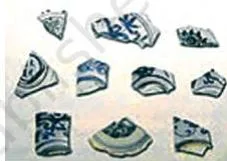
What buildings can and cannot tell us about ordinary people: the stones show where rich traders lived — fine Chinese porcelain was found in the urban core’s north-eastern corner, also the Muslim quarter — but they do not tell us what the poor thought. That is why Barbosa’s description of the common people’s houses as “thatched, but nonetheless well built” matters (pp. 178–179).
The royal centre and the mahanavami dibba
The “royal centre” is a modern label for the south-western part of the city. Oddly, it included over 60 temples — rulers used temple patronage to legitimise their authority (NCERT, p. 180). About thirty building complexes have been identified as palaces.
Unlike temples, which were built entirely of masonry, the upper parts of these secular buildings were made of perishable materials, so only their bases survive. Paes called the audience hall and the great platform together the “House of Victory” (p. 180).
The mahanavami dibba is a massive platform: about 11,000 sq ft at its base, rising to 40 ft, on one of the highest points in the city. It carried a wooden structure and is covered with relief carvings (p. 181).
Rituals likely coincided with Mahanavami — the “great ninth day” of the autumn festival called Dusehra, Durga Puja or Navaratri in different regions. Kings displayed their prestige on this occasion: worship of the image, worship of the state horse, buffalo sacrifice, dances and wrestling.
Processions of caparisoned horses, elephants, chariots and soldiers passed before the king, who reviewed his army on the last day. The chief nayakas brought tribute and rich gifts.
The enigma: scholars point out that the space around the platform seems too small for such elaborate processions of soldiers and animals. Like other structures in the royal centre, it “remains an enigma” (p. 181). A good essay uses this doubt honestly: describe the rituals the travellers recorded, then note that archaeology cannot confirm the surviving platform hosted them all.
The sacred centre: gopurams, mandapas and temples
The rocky northern end of the city, on the Tungabhadra’s banks, held the sacred core. Local tradition placed the monkey kingdom of Vali and Sugriva in these hills, and said Pampadevi did penance there to marry Virupaksha, the guardian deity, a form of Shiva. That marriage is still celebrated annually (NCERT, p. 185).
The kings ruled on behalf of Virupaksha: royal orders were signed “Shri Virupaksha”, and rulers used the title Hindu Suratrana — a Sanskritised “Hindu Sultan” — to signal their closeness to the gods.
New architectural features marked the period. Raya gopurams (royal gateways) often dwarfed the towers over the central shrines — a statement of imperial power. Mandapas (pavilions) and long pillared corridors ran around the shrines (p. 186).
The Virupaksha temple grew over centuries: the earliest shrine dates to the ninth–tenth centuries, and Krishnadeva Raya built the hall in front of the main shrine to mark his accession, plus the eastern gopuram. The Vitthala temple honoured Vitthala, a form of Vishnu worshipped in Maharashtra — a sign of how Vijayanagara fused different traditions.
Its shrine is designed as a chariot, and chariot streets ran straight from temple gopurams, lined with pillared pavilions where merchants set up shops (pp. 186–188).
How the city was documented
Historians rebuilt Hampi from layered evidence, each piece with its own date:
- 1800 — Colin Mackenzie prepared the first survey map; his initial information came from the memories of priests of the Virupaksha temple and the shrine of Pampadevi (p. 170).
- 1836 — epigraphists began collecting dozens of inscriptions from Hampi’s temples (p. 171).
- 1856 — photographers began recording the monuments, letting scholars study them (p. 171).
- 1876 — J.F. Fleet documented the inscriptions on the temple walls (p. 194).
- Early 1980s — a major documentation project divided the site into 25 squares, each subdivided again, using intensive surveys; dozens of international scholars took part over nearly twenty years (pp. 189–190).
- 1976 / 1986 — Hampi became a site of national importance, then a UNESCO World Heritage site (pp. 189, 194).
The chapter also lists the foreign travellers whose accounts were collated with inscriptions and literature in Telugu, Kannada, Tamil and Sanskrit: Nicolo de Conti (Italy), Abdur Razzaq (Persia) and Afanasii Nikitin (Russia) in the fifteenth century; Barbosa, Paes and Nuniz (Portugal) in the sixteenth (p. 176).
Through the twentieth century the site was preserved by the Archaeological Survey of India and the Karnataka Department of Archaeology and Museums (p. 189).
Reading the Chapter’s Figures
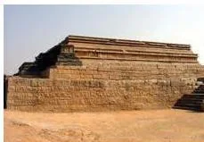
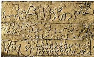
This is a visual chapter: the book asks you to read its photographs, plans and elevations, not just glance at them. Each figure below is explained so you can follow it with your finger on the page.
The city walls: Fig. 7.1
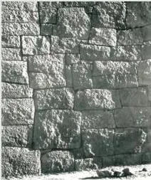
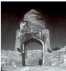
This is the fortification built around the city. Look at the wedge-shaped blocks: no mortar or cementing agent was used anywhere in the construction, and the stone holds itself in place. The massive masonry is slightly tapered, with the inner portion made of earth packed with rubble. Abdur Razzaq counted seven lines of such forts (p. 178).
Mackenzie and his informants: Fig. 7.2
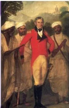
This is a copy, made c. 1825, of an oil painting by Thomas Hickey. On Mackenzie’s left stands his peon Kistnaji holding a telescope; on his right are Brahmana assistants — a Jaina pandit and, behind him, the Telugu Brahmana Cauvellery Ventak Letchmiah (p. 171).
The book’s margin question asks how the artist portrayed Mackenzie and his informants. Mackenzie is the pivot of the scene: the telescope signals surveying, and the Brahmana assistants stand beside him as the local sources of knowledge the painter wants the viewer to see.
Before Vijayanagara: Fig. 7.3
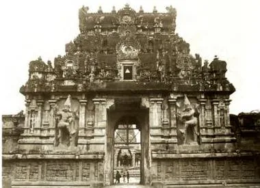
This gateway at Thanjavur belongs to the Chola tradition of temple building. The Vijayanagara rulers, who called themselves rayas, “built on these traditions and carried them literally to new heights” — meaning taller gopurams (p. 172). The chapter places this figure before the raya gopurams to show where the tradition came from.
Water into the city: the aqueduct
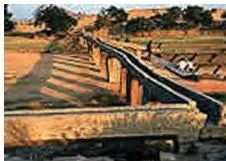
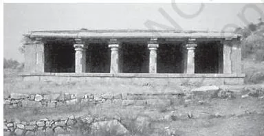
This stone channel carried water into the royal centre — to the palaces, not just the fields. Read it with the Kamalapuram tank, whose channel did exactly this, and with Paes’s account of a tank built by Krishnadeva Raya “at the mouth of two hills”, with water piped from more than three leagues away (pp. 177–178).
The Lotus Mahal: Figs. 7.14 and 7.15
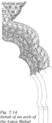
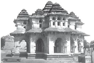
The Lotus Mahal is one of the most beautiful buildings in the royal centre — a name given by British travellers in the nineteenth century. Historians are not sure what it was for; a map drawn by Mackenzie suggests it may have been a council chamber where the king met his advisers (p. 182).
The building had nine towers — a high central one and eight along the sides. The arches, visible in both the arch detail and the photograph, were probably inspired by Indo-Islamic techniques, the same style seen on the gateway into the fortified settlement.
Elephant stables: plan, elevation and photograph (Figs. 7.16a, 7.16b, 7.17)


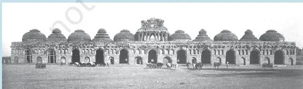
The book uses these three views to teach a key skill: the difference between a plan and an elevation.
- A plan is a horizontal view — the building as if sliced across and seen from above. Fig. 7.16b shows the layout of the chambers side by side.
- An elevation is a vertical view — the front face, showing height and shape. Fig. 7.16a shows the row of domed bays as you would see them standing in front.
- The photograph (Fig. 7.17) shows the building as it survives today, close to the Lotus Mahal.
Compare all three: only the elevation shows height, only the plan shows the exact arrangement on the ground, and the photograph adds setting. The book then asks the honest question — do you think these were actually elephant stables?
The Hazara Rama temple sculpture: Fig. 7.18
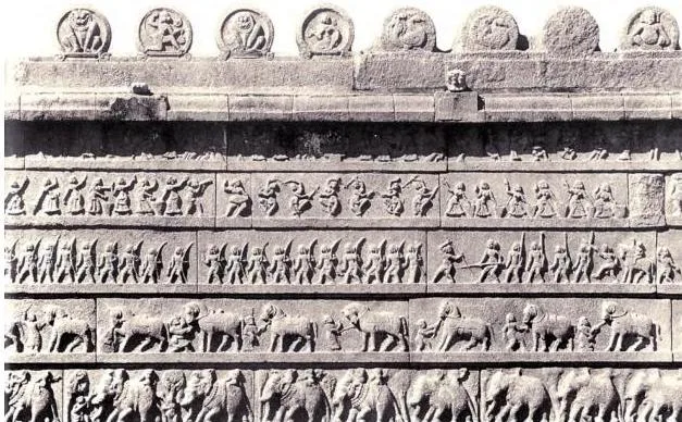
This temple was probably meant for the king and his family alone. The images in its central shrine are missing, but sculpted panels on the walls survive, including scenes from the Ramayana on the inner walls (p. 183).
The margin question asks why elephants and horses were depicted on the panels. Think about what these animals meant to the empire: the amara-nayakas maintained contingents of horses and elephants for the king’s army, so showing them was a display of power and wealth.
Reading the Virupaksha temple plan: Fig. 7.21
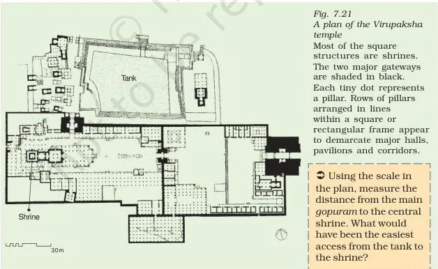
Plans use a code, and the book gives it to you: most of the square structures are shrines; the two major gateways are shaded in black; each tiny dot represents a pillar. Rows of dots within square or rectangular frames mark halls, pavilions and corridors (p. 185).
Now try the task the book sets: using the scale in the plan, measure the distance from the main gopuram to the central shrine, and work out the easiest route from the tank to the shrine. This is exactly the skill the map exercises in the chapter teach — reading a scale and a ground plan together.
The Vitthala temple chariot: Fig. 7.24
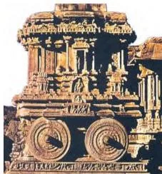
The Vitthala temple honoured Vitthala, a form of Vishnu worshipped mainly in Maharashtra — evidence that Vijayanagara drew on many regional traditions. Its shrine is designed as a chariot, with wheels, in stone (p. 187).
The book asks: “Do you think chariots would have actually been built like this?” The point is that the stone shrine copies the form of a processional chariot made permanent as a temple — a fusion of two traditions in one monument.
Krishnadeva Raya as he wanted to be seen: Fig. 7.31
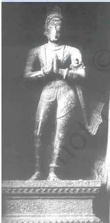
This statue stands on the gopuram of the temple at Chidambaram, Tamil Nadu. The book says plainly: this is “obviously the way in which the ruler wanted to project himself” (p. 192).
Now contrast it with Paes’s physical description of the king: “Of medium height, and of fair complexion and good figure, rather fat than thin; he has on his face signs of smallpox.” Royal self-image versus a traveller’s plain report — the chapter’s neatest lesson in perspective.
The queen’s bath: Fig. 7.32
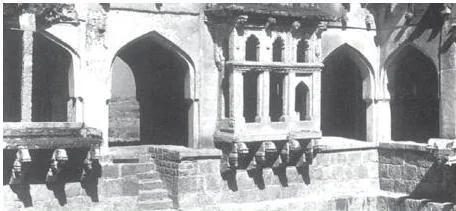
“Known as” is the key phrase. This structure carries a modern name — the queen’s bath — and the chapter never tells us what it was actually used for.
The figure sits at the end of the chapter’s final section, as proof of its central point: buildings survive, but they raise as many questions as they answer, and historians need other sources to interpret them (p. 193).
Key Terms from the An Imperial Capital Chapter
These are the specialised words the chapter expects you to know. The table gives each term, what it means in plain language, and the page where the book uses it.
| Term | What it means | NCERT page |
|---|---|---|
| Vijayanagara | “City of victory” — the name of both the capital city and the empire | p. 170 |
| Hampi | The local name under which the ruined city was remembered | p. 170 |
| Pampadevi | The local mother goddess, from whose name Hampi derives | pp. 170, 185 |
| Karnataka samrajyamu | What contemporaries called the empire | p. 172 |
| raya | Title the Vijayanagara rulers used for themselves | p. 172 |
| gajapati | “Lord of elephants” — the ruling lineage of Orissa | p. 172 |
| ashvapati | “Lord of horses” — the Deccan Sultans in popular tradition | p. 172 |
| narapati | “Lord of men” — the rayas | p. 172 |
| kudirai chetti | A local horse merchant | p. 172 |
| amara-nayaka | A military commander given a territory by the raya; collected taxes and maintained a contingent for the king | p. 175 |
| Raichur doab | The land between the Tungabhadra and Krishna rivers | p. 174 |
| gopuram / raya gopuram | A temple gateway tower / the tall royal gateway | pp. 172, 186 |
| mandapa / kalyana mandapa | A temple pavilion / a hall for celebrating divine weddings | p. 186 |
| mahanavami dibba | The great platform in the royal centre, possibly used for Mahanavami rituals | p. 181 |
| Indo-Islamic architecture | A style that grew from interaction between Turkish Sultanate building features and local practices | p. 178 |
Common Mistakes in the An Imperial Capital Chapter
These are the errors students make most often with this chapter — each with the correction and the page that proves it.
| Mistake | Correct rule | How to check your answer |
|---|---|---|
| Mixing up the dynasty order | Sangama (till 1485) → Saluva (till 1503) → Tuluva (Krishnadeva Raya, 1509–29) → Aravidu (from 1542) | Recite “Sangama Starts, Saluva Seizes, Tuluva Triumphs, Aravidu Arrives”; check pp. 173–175 |
| Saying Krishnadeva Raya founded the empire | The empire was founded in 1336 by Harihara and Bukka; Krishnadeva Raya was a Tuluva ruler (1509–29) | Look for “Harihara and Bukka” and “1336” (pp. 170, 172–174) |
| Blaming “the Sultan of Bijapur” alone for the fall | The combined armies of Bijapur, Ahmadnagar and Golconda defeated Rama Raya at Rakshasi-Tangadi (Talikota) in 1565 | Name all three sultanates, not one (pp. 174–175) |
| Calling Hampi only the sacred centre | Hampi is the local name for the whole ruined city, from goddess Pampadevi | Re-read p. 170: the ruins as a whole |
| Equating amara-nayaka with iqta | The book says the system was “likely derived” from the iqta system — similar features, not identical systems | Quote “it is likely” in your answer (pp. 175–176) |
| Stating the mahanavami dibba certainly hosted grand processions | Scholars doubt the surrounding space was adequate; the book calls it an enigma | Use the word “enigma” with the doubt (p. 181) |
| Swapping the two waterworks | Kamalapuram tank: early 15th century, channel to the royal centre; Hiriya canal: Sangama dynasty, irrigated the valley | Match each name to its job (p. 177) |
| Calling Mackenzie an archaeologist | He was an engineer and antiquarian of the East India Company (1800); formal conservation began only in 1902 under John Marshall | Check the discovery timeline (pp. 170–171, 194) |
Using This Chapter for Board Preparation
The chapter’s own closing questions are the best map of what to revise. Each question tests a specific part of the chapter — this table shows which part.
| Question block | What it tests | Where the material lives |
|---|---|---|
| Q1 — methods used to study Hampi’s ruins | Sources and discovery | pp. 170–171 |
| Q2 — water requirements | Water resources | pp. 177–178 |
| Q3 — enclosing farmland pros and cons | Fortifications and siege strategy | p. 178 |
| Q4 — significance of mahanavami rituals | Royal centre | p. 181 |
| Q5 — the Virupaksha pillar (Fig. 7.33) | Reading sculpture | p. 194 |
| Q6 — is “royal centre” the right label? | Royal centre | pp. 180–181 |
| Q7 — Lotus Mahal and elephant stables architecture | Royal centre buildings | pp. 182–183 |
| Q8 — architectural traditions and their transformation | Sacred centre | pp. 184–188 |
| Q9 — lives of ordinary people | Urban core and travellers’ accounts | pp. 179, 193 |
| Q10 — map work on travellers’ routes | Geography: Italy, Portugal, Iran, Russia | p. 176 |
| Q11–12 — projects | Research and observation | p. 195 |
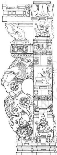
Question 5 asks you to analyse this pillar. The book’s own question tells you what to look for: floral motifs, the animals shown, and the human figures.
Answer in layers: describe what is actually carved; then connect the animals to the chapter’s themes (horses and elephants as the empire’s military strength); then explain the human figures as part of the decorative programme of a temple Krishnadeva Raya embellished with “delicately carved pillars” (p. 187).
A model answer plan for the water supply question (Q2)
A 100–150 word answer needs three or four specific evidence points. Use this order:
- Start with the landscape: the Tungabhadra flows north-east through a natural basin ringed by granite hills, in one of the most arid zones of the peninsula (p. 177).
- Give the general method: embankments along the streams created reservoirs of varying sizes to store rainwater for the city (p. 177).
- Name the two big works: the Kamalapuram tank (early fifteenth century), whose channel watered the royal centre, and the Hiriya canal, which drew from a dam across the Tungabhadra and irrigated the valley between the sacred centre and the urban core (p. 177).
- Add a traveller’s corroboration: Paes described a tank built by Krishnadeva Raya between two hills, with water piped from more than three leagues away and fifteen to twenty thousand workers at the site (p. 178).
- Conclude: the system stored rain, moved water long distances, and served both fields and palace — which is why the city could feed itself.
- 100–150 word answers: three or four specific evidence points — a date, a name, a traveller, a building. Vague praise of “greatness” earns nothing.
- Essays (250–300 words): open with a position (for Q6: “the label ‘royal centre’ is partly misleading because the area included over 60 temples”), then three or four themed paragraphs, then a conclusion.
- Map work (Q10): know the travellers’ homelands — Italy (Conti), Persia (Abdur Razzaq), Russia (Nikitin), Portugal (Barbosa, Paes, Nuniz).
- The margin “Discuss” prompts (pp. 176, 180, 184, 188) are analytical practice — they train exactly the position-taking the essays want.
- A note of caution: textbook contents and the examinable syllabus are not always identical — check the current official syllabus from CBSE before the exam.
Timelines and Key Events of the An Imperial Capital Chapter
The chapter closes not with a summary but with two timelines — one political, one about discovery and conservation. Here they are merged into a single revision pass, with dates as the spine.
| Date | Event | Which timeline |
|---|---|---|
| 1206 | Delhi Sultanate established | Political |
| 1336? | Vijayanagara Empire founded (the question mark means the date is uncertain) | Political |
| 1347 | Bahmani kingdom established | Political |
| 1435 | Gajapati kingdom of Orissa established | Political |
| 1490 | Sultanates of Ahmadnagar, Bijapur and Berar emerge | Political |
| 1510 | Portuguese conquer Goa | Political |
| 1518 | Sultanate of Golconda emerges after the Bahmani collapse | Political |
| 1526 | Mughal empire established by Babur | Political |
| 1800 | Colin Mackenzie visits Vijayanagara | Discovery |
| 1856 | Alexander Greenlaw takes the first detailed photographs of Hampi | Discovery |
| 1876 | J.F. Fleet begins documenting the inscriptions on the temple walls | Discovery |
| 1902 | Conservation begins under John Marshall | Discovery |
| 1986 | Hampi declared a UNESCO World Heritage site | Discovery |
The whole story in four sentences: Harihara and Bukka founded the empire in 1336; four dynasties followed, with Krishnadeva Raya’s reign (1509–29) as the peak; in 1565 Rama Raya’s army was routed by the combined forces of Bijapur, Ahmadnagar and Golconda at Rakshasi-Tangadi, and the city was sacked and abandoned; from 1800 the ruins were rediscovered, and scholars still debate the questions the chapter leaves open.
Those open questions are the chapter’s last-word revision prompts: who planned the buildings, who actually built them, what ordinary people thought of them. The book is clear that buildings alone cannot answer these (pp. 192–193).
Related Resources for the An Imperial Capital Chapter
This listing is maintained for the 2026-27 academic session using the NCERT textbook information available to us. NCERT remains the authority for confirming the latest edition.
Where to go next — inside this site, and in the chapter’s own suggested reading.
If you are revising the whole syllabus, the Class 12 History notes cover every chapter of this book, and the Class 12 notes hub collects notes for all subjects — you can also browse the general CBSE notes collection. Chapters of this book are covered in our notes on Rebels and the Raj and on Theme Four.
The chapter’s own further reading (“If you would like to know more, read”) lists four books:
- Vasundhara Filliozat, Vijayanagara (National Book Trust, New Delhi)
- George Michell, Architecture and Art of Southern India (Cambridge University Press)
- K.A. Nilakanta Sastri, A History of South India (Oxford University Press, New Delhi)
- Burton Stein, Vijayanagara (Foundation Books, New Delhi)
The book also suggests the Vijayanagara Research Project pages hosted by the University of Pennsylvania Museum. For the 1986 declaration, see the official UNESCO World Heritage listing of the Group of Monuments at Hampi.
Sources and Data Verification
This page describes the NCERT Class 12 History textbook Themes in Indian History Part II, chapter “An Imperial Capital: Vijayanagara”, on the printed book pages 170–195 of the current NCERT edition. The official PDF is published at ncert.nic.in.
It covers this one chapter only — not the whole book, and not the CBSE scheme of studies.
The listing is maintained for the current academic session using the NCERT textbook information available to this project.
NCERT settles textbooks, editions and PDFs; CBSE settles the curriculum, syllabus and examinations. Textbook contents and the examinable syllabus are not always identical — check the current official syllabus.
Reference: NCERT Class 12 History textbook, chapter 3, official edition on ncert.nic.in.
FAQs on the An Imperial Capital Chapter
Quick answers to the questions students most often type about this chapter.
Where can I download the NCERT Class 12 History An Imperial Capital chapter PDF?
Open the NCERT Class 12 History An Imperial Capital chapter PDF at ncert.nic.in — the same link appears at the top of this page. It is the chapter on pages 170–195 of Themes in Indian History Part II.
Who founded the Vijayanagara Empire and when?
According to tradition and epigraphic evidence, two brothers, Harihara and Bukka, founded the empire in 1336. The chapter’s timeline prints the date as “1336?” — the question mark is the book’s own note that the date is uncertain (NCERT, pp. 170, 172).
What was the amara-nayaka system in the Vijayanagara Empire?
The amara-nayakas were military commanders given territories by the raya. They collected taxes, kept part of the revenue for themselves and for maintaining a stipulated contingent of horses and elephants, sent annual tribute, and appeared at court with gifts.
The book says many features were likely derived from the iqta system of the Delhi Sultanate; in the seventeenth century many amara-nayakas became independent rulers (pp. 175–176).
Which dynasty did Krishnadeva Raya belong to?
Krishnadeva Raya belonged to the Tuluva dynasty and ruled from 1509 to 1529. His reign saw the acquisition of the Raichur doab (1512), the subduing of Orissa (1514) and severe defeats inflicted on the Sultan of Bijapur (1520) (pp. 173–174).
Who defeated Vijayanagara in the battle of 1565?
Rama Raya’s forces were routed by the combined armies of Bijapur, Ahmadnagar and Golconda at Rakshasi-Tangadi, also known as Talikota. The victorious armies sacked the city, which was totally abandoned within a few years (pp. 174–175).
How was the water supply of Vijayanagara managed?
Through a layered system: embankments along streams created reservoirs to store rainwater; the early-fifteenth-century Kamalapuram tank irrigated fields and sent a channel to the royal centre; and the Hiriya canal drew from a dam across the Tungabhadra to irrigate the valley. Paes’s description of a tank built by Krishnadeva Raya confirms the scale of these works (pp. 177–178).
Explore Class 12 History Books
- Previous: Bhakti-Sufi Traditions: Changes in Religious Beliefs and Devotional Texts
- Next: Peasants, Zamindars
Related chapters: