
Resources and Development Class 10 is Chapter 1 of the NCERT Social Science textbook Contemporary India II — a 12-page chapter that asks what turns anything in nature into a resource, and why careless use of resources now threatens the planet.
The official NCERT PDF of the chapter is offered on this page, followed by a section-by-section walkthrough of what the chapter contains: its definitions, its key figures, its six soil types, and the way its closing exercises test each idea.
Resources and Development Class 10 PDF Download
The official Resources and Development Class 10 PDF is the chapter as printed in the NCERT Contemporary India II textbook, hosted on ncert.nic.in — the same page layout, figures and exercises students use in class, so anything you revise from it matches the book exactly.
| What the chapter holds | Count | Where it is used |
|---|---|---|
| Printed pages | 12 | |
| Figures with NCERT captions | 16 | |
| Tables | 1 | |
| Exercise questions | 3 | answered in our NCERT Solutions |
| Activities | 4 | |
| Official NCERT PDF | Download the chapter PDF | the chapter exactly as NCERT publishes it |
Chapter 1 at a Glance: Sections, Figures and Exercises


The table below lists what the chapter holds — its sections, captioned figures, activity boxes and exercise questions — taken from the official NCERT edition of the chapter.
The chapter’s own section headings, in the order the book prints them, are:
- Resources and Development — the definition and classification of resources (p. 1)
- Development of Resources — the problems created by indiscriminate use (p. 2)
- Resource Planning — why India plans, and the three-stage process (pp. 2–3)
- Land Resources and Land Utilisation (p. 4)
- Land Use Pattern in India (pp. 4–5)
- Land Degradation and Conservation Measures (p. 6)
- Soil as a Resource and Classification of Soils (pp. 6–9)
- Soil Erosion and Soil Conservation (p. 10)
The chapter closes with exercises and a project/activity section that ends in a word puzzle (pp. 10–11).
What This Chapter Covers and How It Flows
The chapter opens with an everyday question — what makes life comfortable in our villages and towns — and builds one continuous argument: nothing in nature is useful by itself.
It becomes a resource only when technology and institutions make it accessible (NCERT, p. 1). The chapter then follows this logic:
- Definition and classification (p. 1): what counts as a resource, and the four bases of classification.
- Development and sustainability (p. 2): the three problems caused by treating resources as free gifts, and the world’s response at the Rio Earth Summit 1992.
- Resource planning (pp. 2–3): why India, with its uneven regional endowments, needs a three-stage planning process.
- Land (pp. 4–5): the most important resource — relief, the five categories of land use, and what India’s land data shows.
- Land degradation (p. 6): the state-wise causes and the conservation measures.
- Soil (pp. 6–10): soil as a living system, the six soil types of India, soil erosion and soil conservation.
The chapter also carries activity boxes asking you to survey your own surroundings, a “Find out” prompt, and a closing project/puzzle whose clues test the same vocabulary (pp. 2, 3, 5, 11).
What Is a Resource? NCERT’s Definition and the Classification Tree
Every classification and every cause-effect argument in this chapter hangs on one definition, so get it exactly right before moving on.
Resource: anything available in our environment that can be used to satisfy our needs, provided it is technologically accessible, economically feasible and culturally acceptable (NCERT, p. 1).
The chapter is equally clear about what a resource is not: resources are not free gifts of nature. They are a function of human activities — people transform what exists in the environment into resources and use them (NCERT, p. 1).
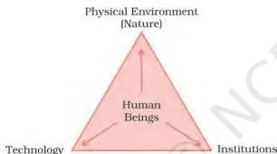
Fig 1.1 shows why this matters. Human beings interact with nature through technology and create institutions to accelerate economic development.
When any corner of this triangle is missing — say, the technology — the same material stays merely “nature” and never becomes a resource (NCERT, p. 1).
Page 1 then gives the classification tree (Fig 1.2). It groups resources by four bases, and the table below shows the categories the chapter lists for each.
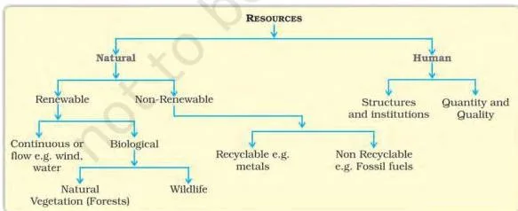
| Basis of classification | Categories the chapter lists | Meaning, with example |
|---|---|---|
| Origin | Biotic and abiotic | Biotic: living sources; abiotic: non-living sources |
| Exhaustibility | Renewable and non-renewable | Water is the renewable example; minerals such as coal are non-renewable |
| Ownership | Individual, community, national, international | Who holds or controls the resource |
| Status of development | Potential, developed, stock and reserves | How far a resource has been developed for use |
The examples the chapter itself settles on are water (renewable) and minerals such as coal (non-renewable); the same pair runs through the regional examples later in the chapter.
Sustainable Development: The Problems and the Rio Earth Summit 1992
This is the chapter’s argument for why we cannot keep using resources carelessly — and what “development without damage” means.
Treating resources as free gifts of nature led to three major problems (NCERT, p. 2):
- Depletion of resources to satisfy the greed of a few individuals.
- Accumulation of resources in a few hands, dividing society into haves and have-nots.
- Global ecological crises: global warming, ozone layer depletion, environmental pollution and land degradation.
The answer the chapter adopts is sustainable development: development that takes place without damaging the environment, so the present does not compromise the needs of future generations (NCERT, p. 2).
The world acted on this in June 1992, when more than 100 heads of state met at the Rio de Janeiro Earth Summit in Brazil.
They signed the Declaration on Global Climatic Change and Biological Diversity, endorsed the global Forest Principles, and adopted Agenda 21 (NCERT, p. 2).
Agenda 21 is the declaration aimed at achieving global sustainable development — combating environmental damage, poverty and disease through global cooperation. Its key objective: every local government should draw up its own local Agenda 21 (NCERT, p. 2).
Resource Planning in India: Why It Is Needed and How It Works
A country as large and varied as India cannot manage its resources uniformly — every region has some resources and lacks others, so planning is the accepted strategy for judicious use (NCERT, p. 2).
The chapter’s four regional examples make the point:
- Jharkhand, Chhattisgarh and Madhya Pradesh — rich in minerals and coal deposits.
- Arunachal Pradesh — abundant water resources, but lacking infrastructural development.
- Rajasthan — well endowed with solar and wind energy, but short of water.
- Ladakh — a rich cultural heritage, but deficient in water, infrastructure and vital minerals.
Resource planning is a complex three-stage process (NCERT, p. 3):
- Identification and inventory of resources — surveying, mapping, and qualitative and quantitative estimation.
- Evolving a planning structure — with appropriate technology, skill and institutional set-up for implementing resource development plans.
- Matching plans — aligning resource development plans with the overall national development plans.
India has pursued this from the First Five Year Plan launched after Independence (NCERT, p. 3).
The conservation thread runs through the chapter’s history (NCERT, p. 3):
- Gandhiji’s warning: “There is enough for everybody’s need and not for anybody’s greed.”
- The Club of Rome (1968) advocated resource conservation systematically.
- Schumacher’s Small is Beautiful (1974) restated the Gandhian philosophy.
- The Brundtland Commission Report (1987) introduced the concept of sustainable development, later published as Our Common Future.
- The Earth Summit at Rio de Janeiro in 1992 followed.
Why does availability alone not guarantee development? The history of colonisation shows that rich resources in colonies attracted invaders — it was the colonisers’ higher technology that let them exploit those resources.
So resources contribute to development only with appropriate technology, quality of human resources and the people’s historical experience (NCERT, p. 3).
Land Resources, Land Utilisation and Land Use Pattern in India
Land is the resource we live on, farm on and build on — and its total extent is fixed. How India uses that limited land is therefore a planning question (NCERT, p. 4).
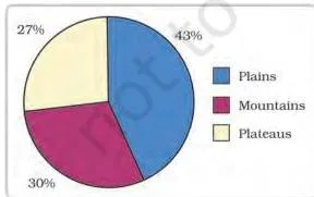
Fig 1.3 maps India’s relief. About 43 per cent of the land area is plain, providing facilities for agriculture and industry; 30 per cent is mountains, which ensure perennial river flow and provide tourism and ecological value; about 27 per cent is plateau, holding rich reserves of minerals, fossil fuels and forests (NCERT, p. 4).
Land is used under five categories (NCERT, p. 4):
- Forests.
- Land not available for cultivation — barren and waste land, plus land under buildings, roads and factories.
- Other uncultivated land — permanent pastures and grazing land; land under miscellaneous tree crops; culturable waste land left uncultivated for more than 5 agricultural years.
- Fallow lands — current fallow (left for one or less than one agricultural year) and other than current fallow (left for 1 to 5 agricultural years).
- Net sown area — the physical extent of land on which crops are sown and harvested.
Two definitions from this list do most of the work in questions: net sown area is the physical extent of land on which crops are sown and harvested, while gross cropped area is the net sown area plus the area sown more than once in an agricultural year (NCERT, p. 4).
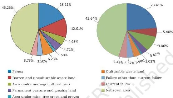
Fig 1.4 puts the categories together as two pie charts, for 1960-61 and 2026-27. The activity in the book asks one sharp question: why did net sown area and land under forests change only marginally between the two years?
The comparison habit is to read each category’s slice in both charts — the category that barely moves is exactly the one the question is about (NCERT, p. 5).
The data behind the charts carries its own caveats (NCERT, p. 5):
- India’s total geographical area is 3.28 million sq km, but land use data covers 93 per cent of it — most north-east states except Assam have not fully reported, and parts of Jammu and Kashmir have not been surveyed.
- Net sown area is over 80 per cent of total area in Punjab and Haryana, but less than 10 per cent in Arunachal Pradesh, Mizoram, Manipur and the Andaman and Nicobar Islands.
- Forest area is far lower than the desired 33 per cent of geographical area outlined in the National Forest Policy (1952).
- Waste land includes rocky, arid and desert areas; land under non-agricultural uses includes settlements, roads, railways and industry.
Land Degradation: Region-Wise Causes and the Conservation Measures
Ninety-five per cent of our basic needs for food, shelter and clothing come from land, so damaging it affects everyone (NCERT, p. 6). Continuous use without conservation measures has resulted in land degradation.
Each main human cause is tied to specific states:
| Cause of degradation | States where it dominates | What happens |
|---|---|---|
| Mining and quarrying | Jharkhand, Chhattisgarh, Madhya Pradesh, Odisha | Deforestation from mining; abandoned sites leave deep scars and overburden |
| Overgrazing | Gujarat, Rajasthan, Madhya Pradesh, Maharashtra | Grass cover destroyed, exposing the soil |
| Over-irrigation | Punjab, Haryana, western Uttar Pradesh | Water logging raises salinity and alkalinity in the soil |
| Mineral processing dust | Limestone, calcite and soapstone grinding areas | Dust settles on land and retards water infiltration |
| Industrial effluents | Many parts of the country | A major source of land and water pollution |
The remedies are a matched list (NCERT, p. 6):
- Afforestation and proper management of grazing.
- Planting shelter belts, controlling overgrazing, and stabilising sand dunes with thorny bushes in arid areas.
- Proper management of waste lands.
- Controlling mining activities.
- Proper discharge and disposal of industrial effluents after treatment.
Soil as a Resource: The Six Soil Types of India
Soil is a living system that takes millions of years to build up even a few centimetres of depth — once it is eroded, it is effectively lost on any human time scale. That is why the chapter calls it the most important natural resource (NCERT, p. 6).
Soil forms through relief, parent rock, climate, vegetation, other life forms and time, driven by forces such as temperature change, running water, wind, glaciers and decomposers (NCERT, p. 6).
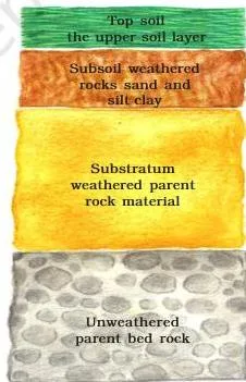
Fig 1.5 shows the soil profile — a vertical section through the soil. Read it as evidence that soil is not a uniform mass but a layered system of organic (humus) and inorganic material (NCERT, p. 6).

On the basis of factors of formation, colour, thickness, texture, age, and chemical and physical properties, the soils of India are classified into different types (NCERT, pp. 6–7). The map below is the location source for everything that follows.

Alluvial Soil
Alluvial soil is the most widely spread and most important soil in India — the entire northern plains are made of it (NCERT, p. 7).
- Where: the northern plains, deposited by the Indus, Ganga and Brahmaputra river systems; a narrow corridor into Rajasthan and Gujarat; the eastern coastal deltas of the Mahanadi, Godavari, Krishna and Kaveri.
- Make-up: various proportions of sand, silt and clay; coarser near the break of slope, as in the piedmont plains of the Duars, Chos and Terai.
- Age kinds: bangar (old alluvial, higher concentration of kanker nodules) and khadar (new alluvial). The book’s sentence comparing them is easy to misread — the intended meaning is that khadar has more fine particles and is more fertile than bangar (NCERT, p. 7).
- Nutrients and crops: adequate potash, phosphoric acid and lime; ideal for sugarcane, paddy, wheat and other cereal and pulse crops.

The photograph (Fig 1.6) shows alluvial soil as it appears in the field; the chapter describes it as sand, silt and clay in various proportions (NCERT, p. 7).
Black Soil
Black soil is also called regur, or black cotton soil, because it is ideal for growing cotton (NCERT, p. 7).
- Where: the Deccan trap (basalt) region — the plateaus of Maharashtra, Saurashtra, Malwa, Madhya Pradesh and Chhattisgarh, extending along the Godavari and Krishna valleys.
- Properties: extremely fine clayey material; holds moisture well; rich in calcium carbonate, magnesium, potash and lime; poor in phosphoric content; develops deep cracks in hot weather that help aeration; sticky when wet and difficult to work unless tilled after the first shower or during the pre-monsoon period.
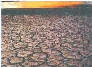
Fig 1.7 shows the dark regur soil whose deep cracks let air reach the lower layers during the hot season (NCERT, pp. 7–8).
Red and Yellow Soils
Red and yellow soils develop on crystalline igneous rocks in the low-rainfall areas of the eastern and southern Deccan plateau, with further patches in Odisha, Chhattisgarh, the southern middle Ganga plain and the piedmont zone of the Western Ghats (NCERT, p. 9).
The soil gets a reddish colour from the diffusion of iron in crystalline and metamorphic rocks, and looks yellow when the iron occurs in a hydrated form (NCERT, p. 9).
Laterite Soil
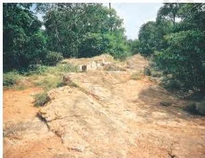
“Later” is Latin for brick — and laterite soil is the brick-like soil of tropical and subtropical climates with alternate wet and dry seasons (NCERT, p. 9).
- How it forms: intense leaching due to heavy rain.
- Properties: deep to very deep, acidic (pH below 6), generally deficient in plant nutrients; humus-rich under deciduous and evergreen forests, humus-poor under sparse vegetation and in semi-arid environments; prone to erosion and degradation.
- Where: southern states, the Western Ghats region of Maharashtra, Odisha, parts of West Bengal and the north-east.
- Crops: tea and coffee in the hilly areas of Karnataka, Kerala and Tamil Nadu after appropriate soil conservation; cashew in Tamil Nadu, Andhra Pradesh and Kerala.
Arid Soils
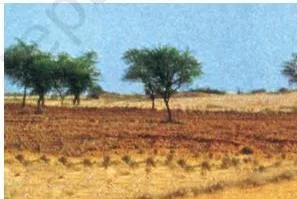
Arid soils are the sandy soils of dry regions, ranging from red to brown in colour and saline in nature (NCERT, p. 9).
- Where: the dry west; the chapter’s example is western Rajasthan, where proper irrigation has made the soils cultivable.
- Properties: sandy texture; saline; lack humus and moisture because of the dry climate, high temperature and fast evaporation; common salt is obtained by evaporation where salt content is very high; kankar in the lower horizons restricts infiltration of water.
Forest Soils
Forest soils occur in hilly and mountainous areas with sufficient rain forests (NCERT, p. 9).
- Variation with altitude: loamy and silty in valley sides; coarse-grained on upper slopes.
- Cold regions: in snow-covered Himalayan areas the soils are acidic with low humus content.
- Fertile spots: the lower valleys, river terraces and alluvial fans.
One table brings the six soil types together for revision:
| Soil type | Location | Key properties | Crops |
|---|---|---|---|
| Alluvial | Northern plains; eastern coastal deltas | Sand-silt-clay mix; khadar more fertile than bangar; rich in potash, phosphoric acid and lime | Sugarcane, paddy, wheat, pulses |
| Black (regur) | Deccan trap: Maharashtra, Saurashtra, Malwa, Madhya Pradesh, Chhattisgarh; Godavari-Krishna valleys | Fine clayey; holds moisture; rich in calcium carbonate, magnesium, potash and lime; poor in phosphoric content | Cotton |
| Red and yellow | Eastern and southern Deccan; Odisha, Chhattisgarh, southern middle Ganga plain, piedmont of Western Ghats | Red from iron diffusion; yellow when hydrated | — |
| Laterite | Southern states; Western Ghats of Maharashtra; Odisha; parts of West Bengal and the north-east | Deep, acidic (pH below 6), leached, nutrient-deficient | Tea, coffee; cashew |
| Arid | Dry west, for example western Rajasthan | Sandy, saline; kankar in lower horizons; lacks humus and moisture | Cultivable after irrigation |
| Forest | Hilly and mountainous areas | Loamy and silty in valleys, coarse on upper slopes; acidic with low humus in snow areas | — |
Soil Erosion and the Methods of Soil Conservation
Soil formation and soil erosion go on simultaneously and normally stay in balance — human activity is what disturbs that balance (NCERT, p. 10).
Soil erosion is the denudation of the soil cover and its subsequent washing down (NCERT, p. 10). Human causes include deforestation, overgrazing, construction and mining; natural forces include wind, glacier and water.
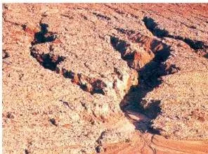
- Gully erosion: running water cuts deep channels (gullies) through clayey soils; the land becomes unfit for cultivation and is called bad land — in the Chambal basin, ravines.
- Sheet erosion: water flows as a sheet over large areas down a slope and washes away the top soil.
- Wind erosion: wind blows loose soil off flat or sloping land.
- Defective farming: ploughing up and down slopes forms channels for the quick flow of water.
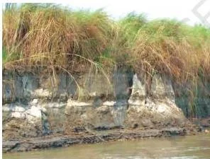
Fig 1.10 is the chapter’s general picture of soil erosion — the denudation and washing down of the soil cover. Fig 1.11 shows the sharper case: gully erosion, where running water has cut deep channels into the land, creating bad land (NCERT, p. 10).

Four conservation methods match these problems (NCERT, p. 10):
- Contour ploughing: ploughing along contour lines decelerates the flow of water down slopes.
- Terrace cultivation: steps cut on slopes restrict erosion; the western and central Himalayas have well developed terrace farming.
- Strip cropping: large fields divided into strips, with grass left between crops to break the force of the wind.
- Shelter belts: rows of trees; these have significantly helped stabilise sand dunes and the desert in western India.
How to Read the Key Figures of This Chapter
Three figures in this chapter do heavy duty in questions — the relief map, the paired pie charts and the soil map. Each rewards a specific reading habit.
Fig 1.3 (India: Land under important Relief Features): fix the three relief categories in your mind. Plains (43 per cent) provide for agriculture and industry; mountains (30 per cent) for perennial rivers, tourism and ecology; the plateau (27 per cent) for minerals, fossil fuels and forests. Any location question about what a relief type offers is answered by this map (NCERT, p. 4).
Fig 1.4 (land use, 1960-61 vs 2026-27): the habit for paired pie charts is comparison, category by category. Ask of each slice: did it grow, shrink or stay about the same? Net sown area and forest moved only marginally — the chapter’s own activity asks exactly this question (NCERT, p. 5).
The answer connects to the forest target: forest area is far lower than the 33 per cent of geographical area outlined in the National Forest Policy (1952) (NCERT, p. 5).
India: Major Soil Types map (p. 8): one map answers the location half of every soil question. A question like “where is black soil found” is answered straight off the map — Maharashtra, Saurashtra, Malwa, Madhya Pradesh and Chhattisgarh, extending along the Godavari-Krishna valleys — then confirmed against the text (NCERT, p. 7).
The complete set of the chapter’s figures is gathered together below for quick revision.
Definitions: Key Terms from Resources and Development
This chapter introduces a lot of geography vocabulary, and short-answer marks usually go to using these terms precisely. The table gives each term a one-line meaning with its page.
| Term | Meaning | NCERT page |
|---|---|---|
| Resource | Anything in the environment usable to satisfy needs when it is technologically accessible, economically feasible and culturally acceptable | 1 |
| Biotic / abiotic | Living sources / non-living sources | 1 |
| Renewable / non-renewable | Can be replenished by nature / present in limited stock, e.g. minerals and coal | 1 |
| Sustainable development | Development without damaging the environment, so present needs do not compromise future generations | 2 |
| Agenda 21 | Rio 1992 declaration for global sustainable development; every local government to draw its own local Agenda 21 | 2 |
| Net sown area | Physical extent of land on which crops are sown and harvested | 4 |
| Gross cropped area | Net sown area plus land sown more than once in an agricultural year | 4 |
| Current fallow | Land left uncultivated for one or less than one agricultural year | 4 |
| Other than current fallow | Land left uncultivated for 1 to 5 agricultural years | 4 |
| Waste land | Rocky, arid and desert areas | 5 |
| Land degradation | Decline in land quality from continuous use without conservation | 5–6 |
| Bangar | Old alluvial soil with a higher concentration of kanker nodules | 7 |
| Khadar | New alluvial soil; more fine particles and more fertile than bangar | 7 |
| Regur | Another name for black soil, ideal for cotton | 7 |
| Leaching | Intense washing of soil by heavy rain, which removes plant nutrients; forms laterite soil | 9 |
| Gullies | Deep channels cut by running water in clayey soils | 10 |
| Bad land | Land made unfit for cultivation by gully erosion; called ravines in the Chambal basin | 10 |
| Sheet erosion | Washing away of the top soil when water flows as a sheet down a slope | 10 |
| Contour ploughing | Ploughing along contour lines to slow the flow of water down slopes | 10 |
| Terrace cultivation | Cutting steps into slopes to restrict erosion | 10 |
| Strip cropping | Leaving strips of grass between crops to break the force of the wind | 10 |
| Shelter belts | Rows of trees planted to shelter land; help stabilise sand dunes and the desert in western India | 10 |
Common Mistakes Students Make in This Chapter
Most lost marks in this chapter come from misreading a few definitions and swapping similar terms. Get these six straight and the rest follows.
| Mistake | Correct rule | How to check your answer |
|---|---|---|
| “Resources are free gifts of nature.” | Resources are a function of human activities — usable only when technology, economics and culture allow (p. 1) | Ask: would this material be a resource without the technology to access it? |
| Reading bangar as more fertile than khadar | Bangar is old alluvial with more kanker nodules; khadar is new alluvial and more fertile, with more fine particles (p. 7) | Remember that khadar, the newer soil, is the more fertile one |
| Confusing net sown area with gross cropped area | Net sown area is the physical extent of land under crops; gross cropped area counts the same land again when sown more than once in a year (p. 4) | Does the figure count the same plot twice? Twice = gross cropped area |
| Confusing current fallow with other than current fallow | Current fallow: up to 1 agricultural year; other than current fallow: 1 to 5 years; culturable waste: more than 5 years (p. 4) | Attach the exact number of years to the term |
| Naming intensive cultivation as the main cause of degradation in Punjab | The chapter names over-irrigation — water logging raises salinity and alkalinity (p. 6) | Match the states: Punjab, Haryana and western UP = over-irrigation |
| Assuming forest area is close to the 33 per cent target | The chapter says forest area is far lower than the 33 per cent outlined in the National Forest Policy (1952) (p. 5) | Remember the 33 per cent figure is the desired target, not the actual area |
Two more pairs are worth keeping apart: laterite (brick-like, intensively leached, acidic, p. 9) vs arid (sandy, saline, with kankar, p. 9), and gully erosion (deep channels, bad land, p. 10) vs sheet erosion (top soil washed away in sheets, p. 10).
Exam Notes: How the Chapter’s Exercises Test You
The best source of question patterns for this chapter is the exercise NCERT prints at the end of it (pp. 10–11). Every question maps to specific content:
| Exercise question | What it tests | Where the answer lives |
|---|---|---|
| Q1 (i): main cause of land degradation in Punjab | Over-irrigation — water logging raises salinity and alkalinity | p. 6 |
| Q1 (ii): state where terrace cultivation is practised | Uttarakhand — terrace farming is well developed in the western and central Himalayas | p. 10 |
| Q1 (iii): state where black soil predominates | Maharashtra | p. 7 |
| Q2 (i): three states with black soil and its main crop | Maharashtra, Madhya Pradesh and Chhattisgarh (the chapter also names Saurashtra and Malwa); the crop is cotton | p. 7 |
| Q2 (ii): soil of the eastern coastal deltas, with three features | Alluvial soil — sand, silt and clay in varying proportions; fertile; khadar/bangar kinds | p. 7 |
| Q2 (iii): controlling soil erosion in hilly areas | Terrace cultivation, contour ploughing, afforestation | p. 10 |
| Q3 (i): land use pattern and why forest area has not increased much since 1960-61 | The five land use categories plus the Fig 1.4 comparison; forest area far below the 33 per cent policy target | pp. 4–5 |
| Q3 (ii): how technical and economic development led to more consumption of resources | Resources become usable through technology; availability alone is not enough without technology, skills and institutions | pp. 1–3 |
Here is one original practice sum built from the chapter’s own numbers. India’s total geographical area is 3.28 million sq km, and land use data is available for only 93 per cent of it (NCERT, p. 5). What area is left out of the reporting?
\[ \text{Unreported area} = 3.28 \times (1 – 0.93) = 3.28 \times 0.07 \approx 0.23\ \text{million sq km} \]
The chapter explains the gap in words: land use reporting for most of the north-east states except Assam has not been done fully, and some areas of Jammu and Kashmir have not been surveyed (NCERT, p. 5).
The closing project/puzzle (p. 11) is a fast last-minute revision tool — its clues ask for natural endowments, a non-renewable resource, the soil with high water retaining capacity (black soil), the intensively leached soils of the monsoon climate (laterite), afforestation and the soils of the Great Plains (alluvial).
The letter grid itself carries three of the answers in its squares: minerals, afforestation and laterite.
One caution: textbook contents and the examinable syllabus are not always identical, so check the current official CBSE syllabus for what is examinable this session.
Revision Summary: The Whole Chapter in One Read
If you remember one chain of ideas from this chapter, make it this one — eight links that rebuild the whole argument.
- A resource is anything in the environment that satisfies needs when it is technologically accessible, economically feasible and culturally acceptable — and resources are not free gifts of nature (p. 1).
- Resources classify by four bases: origin, exhaustibility, ownership, and status of development (p. 1).
- Indiscriminate use caused depletion, accumulation in a few hands and global ecological crises, so the world adopted sustainable development — meeting present needs without compromising future generations — framed at Rio 1992 through Agenda 21 (p. 2).
- India needs resource planning because its regions are unequally endowed; planning has three stages, and India has pursued it since the First Five Year Plan (pp. 2–3).
- Land is finite: 43 per cent plains, 30 per cent mountains, 27 per cent plateau, used under five categories with net sown area the key measure (p. 4).
- Land degrades through mining, overgrazing and over-irrigation in specific states, and each cause has a conservation remedy (p. 6).
- Soil is a living system; India’s six soil types — alluvial, black, red and yellow, laterite, arid and forest — each have distinct locations and properties (pp. 6–9).
- Soil erosion takes gully, sheet and wind forms, countered by contour ploughing, terrace cultivation, strip cropping and shelter belts (p. 10).
The one-line takeaway the chapter keeps returning to: resources serve development only when combined with appropriate technology and institutions (p. 3).
Related Resources
If you are studying Contemporary India II chapter by chapter, the natural next step is the chapter that follows this one. Use these links to move around the site:
- Class 10 Social Science notes — notes across the Class 10 social science chapters.
- Class 10 study resources — the main hub for Class 10 material.
- CBSE notes homepage — browse notes for all classes and subjects.
- Forest and Wildlife Resources notes — Chapter 2 of Contemporary India II, the chapter that follows this one.
The same chapter is available as the official NCERT PDF on the NCERT textbook portal, published at ncert.nic.in, should you need the full text of any exercise discussed above.
Reference: NCERT Class 10 Contemporary India-II textbook, chapter 1, official edition on ncert.nic.in.
Sources and Data Verification
- All concepts, figures and page references on this page describe the NCERT Class 10 Social Science textbook Contemporary India II, Chapter 1 (Resources and Development), official NCERT edition.
- This page covers that single chapter of that book only — not the full CBSE syllabus for Class 10 Social Science.
- The page is maintained for the current academic session using the NCERT edition available on ncert.nic.in.
- NCERT settles textbooks, editions and PDFs; CBSE settles the curriculum, syllabus and examinations.
Frequently Asked Questions
What is a resource according to NCERT Class 10 Geography Chapter 1?
Anything in the environment that can be used to satisfy our needs — provided it is technologically accessible, economically feasible and culturally acceptable — is termed a resource (NCERT, p. 1). The chapter insists resources are not free gifts of nature: they become resources only through human activity.
What is the difference between bangar and khadar soil?
Bangar is old alluvial soil with a higher concentration of kanker nodules; khadar is new alluvial soil. The book’s comparison sentence is easy to misread — the intended meaning is that khadar has more fine particles and is more fertile than bangar (NCERT, p. 7).
Why is resource planning important in India?
Because India has enormous diversity in the availability of resources: Jharkhand and Chhattisgarh are rich in minerals, Arunachal Pradesh has abundant water but lacks infrastructure, and Rajasthan has solar and wind energy but little water.
Planning is the accepted strategy for judicious use of resources and works in three stages — identification and inventory, building a planning structure, and matching resource plans with national plans (NCERT, pp. 2–3).
What are the main causes of land degradation in India?
Mining and quarrying in Jharkhand, Chhattisgarh, Madhya Pradesh and Odisha; overgrazing in Gujarat, Rajasthan, Madhya Pradesh and Maharashtra; over-irrigation in Punjab, Haryana and western Uttar Pradesh; dust from mineral processing; and industrial effluents (NCERT, p. 6).
Which are the six soil types described in this chapter?
Alluvial, black (regur), red and yellow, laterite, arid and forest soils (NCERT, pp. 7–9). Alluvial soil fills the northern plains, black soil covers the Deccan trap region, laterite forms by intense leaching in the wet-dry tropics, arid soils are sandy and saline in the dry west, and forest soils occupy hilly and mountainous areas.
Explore Class 10 Social Science Books
Class 10 Social Science on LearnCBSE:
Related chapters:
- Power-sharing
- The Rise of Nationalism in Europe
- Development