
This page covers Chapter 7, Lifelines of National Economy, from NCERT’s Class 10 Social Science book Contemporary India – II.
The chapter runs across printed pages 70-83 of the textbook, and the official file published on ncert.nic.in is the exact text of the NCERT book — download the Lifelines of National Economy Class 10 NCERT chapter PDF to read it offline, print it or mark it up as you study.
| What the chapter holds | Count | Where it is used |
|---|---|---|
| Printed pages | 13 | |
| Figures with NCERT captions | 15 | |
| Tables | 2 | |
| Exercise questions | 3 | answered in our NCERT Solutions |
| Activities | 5 | |
| Official NCERT PDF | Download the chapter PDF | the chapter exactly as NCERT publishes it |
Lifelines of National Economy Class 10: What’s in the Chapter
The table below shows what the official chapter file contains — its numbered sections, captioned figures, activity blocks and exercise sets — so you know exactly what you are downloading before you open it.
Why the Chapter Calls Transport and Communication Lifelines
A country’s economy dies if goods cannot reach the people who need them. That single idea is why the chapter names transport, communication and trade the lifelines of the national economy.
Goods and services do not move from supply locations to demand locations on their own. Traders organise the movement and bring products to consumers through transport, so the pace of a country’s development depends on production and on movement over space (NCERT, p. 71).
Movement takes place over three domains of the earth — land, water and air — and transport is classified accordingly. But transport alone cannot do the job: goods need orders, and orders travel by communication. In the book’s own conclusion, transport, communication and trade are complementary to each other (NCERT, p. 71).
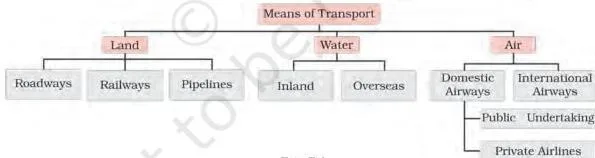
Fig 7.1 opens the chapter with the idea the whole lesson proves: modern means of transport and communication working together. Sort what you can see into the three domains — land (roads, rail), water (ships) and air — and then into communication (radio, television, cinema, the internet). Every item you identify returns as a section of the chapter.
This network is what keeps a vast, diverse country working: railways, airways, waterways, newspapers, radio, television, cinema and the internet link regions across physical and social distance, while trade from local to international levels adds vitality to the economy. A dense and efficient transport-communication network is a prerequisite for local, national and global trade (NCERT, p. 71).
Roadways: Six Classes of Roads and Why Roads Beat Railways
Roads are the most flexible mode of transport because they reach places rails cannot. India has the second largest road network in the world, about 62.16 lakh km in 2026-27, and roadways came before railways in India (NCERT, p. 71).
Why roads have an edge over railways
The book gives six reasons (NCERT, pp. 71-72):
- construction cost of roads is much lower than that of railway lines;
- roads can traverse comparatively more dissected and undulating topography;
- roads can negotiate higher gradients, so they can climb mountains such as the Himalayas;
- road transport is economical for few persons and smaller amounts of goods over short distances;
- roads provide door-to-door service, so loading and unloading costs are much lower;
- roads act as a feeder to other modes, linking railway stations, airports and seaports.
The six classes of Indian roads
Indian roads are classified by capacity into six classes (NCERT, pp. 72-74):
- Golden Quadrilateral Super Highways: a major road project linking Delhi-Kolkata-Chennai-Mumbai-Delhi by six-lane super highways, plus the North-South and East-West corridors; implemented by the National Highway Authority of India (NHAI).
- National Highways: link the extreme parts of the country; the primary road system of India.
- State Highways: link a state capital with different district headquarters.
- District Roads: connect district headquarters with other places of the district.
- Other Roads (rural roads): link villages with towns; they received special impetus under the Pradhan Mantri Grameen Sadak Yojana, which aims to give every village an all-weather motorable road to a major town.
- Border Roads: built and maintained by the Border Roads Organisation (BRO), established in 1960, for roads of strategic importance in the northern and north-eastern border areas.
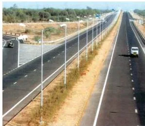
Fig 7.2 shows the Ahmedabad-Vadodara Expressway — a divided, multi-lane highway of the kind the super highway project builds. It is a working example of what the chapter means by six-lane corridors that reduce time and distance between India’s mega cities (NCERT, p. 72).

The border-road photograph belongs to the sixth class in the list above. Roads in the bordering areas are constructed and maintained by the Border Roads Organisation, and they have improved accessibility in areas of difficult terrain and helped the economic development of these areas (NCERT, p. 72).
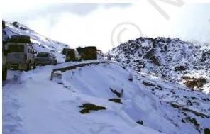
Fig 7.4 shows traffic on a north-eastern border road in Arunachal Pradesh — the payoff of border-road building in a single image. Roads bring accessibility, and accessibility brings economic development to areas of difficult terrain.

Fig 7.3 shows hilly tracts, where roads can climb gradients that railways cannot. This is reason (c) — roads can negotiate higher gradients — made visible, and it is why mountain regions like the Himalayas rely on roads (NCERT, p. 74).
The three corridors: a memory aid
The super highway project has three parts, and exam questions love the terminals:
| Corridor | Terminals | What it does |
|---|---|---|
| Golden Quadrilateral | Delhi-Kolkata-Chennai-Mumbai-Delhi | six-lane super highways linking the mega cities |
| North-South Corridor | Srinagar (Jammu & Kashmir) to Kanniyakumari (Tamil Nadu) | connects the far north with the southern tip |
| East-West Corridor | Silchar (Assam) to Porbandar (Gujarat) | connects the north-east with the west coast |
Two tricks keep these terminals straight. The North-South corridor spans the length of India — Srinagar in the mountains to Kanniyakumari at the southern tip. The East-West corridor spans the width — Silchar to Porbandar — and both towns end in “-ar”, which is exactly the pair exercise question 1(i) asks for (NCERT, p. 72).
Atal Tunnel and road surfaces
The Do you know? box deserves special attention: the Atal Tunnel (9.02 km), the world’s longest highway tunnel, was built by the Border Roads Organisation. It connects Manali to the Lahul-Spiti valley all year round — earlier the valley stayed cut off for about six months each year owing to heavy snowfall.
The tunnel lies in the Pir Panjal range of the Himalayas at an altitude of 3,000 metres above mean sea level (NCERT, p. 74).
Roads are also classified by material. Metalled roads — made of cement, concrete or bitumen of coal — are all-weather roads. Unmetalled roads go out of use in the rainy season (NCERT, p. 74).
Railways: The Principal Mode and the Geography of Its Network
Rail carries huge volumes of freight and passengers over long distances, but tracks can only be laid where the land allows. That is why the railway network’s spread across India is a geography lesson in itself.
Railways are the principal mode of transportation for freight and passengers in India, and an integrating force for more than 150 years. The Indian Railways is the largest public sector undertaking in the country; the first train ran from Mumbai to Thane in 1853, covering 34 km, and the network is now reorganised into 17 zones (NCERT, p. 74).

Study the distribution map of the railway network next to the text’s explanation. The pattern is shaped by physiographic, economic and administrative factors: the northern plains, with vast level land, high population density and rich agricultural resources, provided the most favourable conditions, so the densest web lies there (NCERT, p. 74).
The map thins out where the text says construction was difficult — the Himalayan mountain region, the sandy plain of western Rajasthan, the swamps of Gujarat and the forested tracts of Madhya Pradesh, Chhattisgarh, Odisha and Jharkhand.
Three more points complete the geography of the network:
- rivers: the northern plains’ wide river beds require the construction of bridges — an obstacle;
- peninsular hills: tracks are laid through low hills, gaps or tunnels, and the Sahyadri (Western Ghats) is crossed only through gaps or passes;
- the Konkan railway along the west coast opened up one of India’s most important economic regions but has faced sinking tracks and landslides (NCERT, p. 74).
How to read the railway gauge table. The Indian railway network runs on multiple gauges over 67,956 km (Table 7.1, NCERT, p. 74):
| Gauge | Track width (metres) | Route (km) |
|---|---|---|
| Broad Gauge | 1.676 | 63,950 |
| Metre Gauge | 1.000 | 2,402 |
| Narrow Gauge | 0.762 and 0.610 | 1,604 |
| Total | 67,956 |
Read the column, not just the rows: broad gauge alone covers 63,950 of the 67,956 route km — roughly 94% of the network. That is why broad gauge dominates: one track width means one standardised network. It also answers the Quiz Drive clue “the rail gauge with a track width of 1.676 m” — broad gauge.

The photograph of the railway line extended from Banihal to Baramula in the Kashmir Valley (NCERT, p. 76) shows the present tense of the Himalayan problem: engineers pushing tracks into terrain the text classifies as unfavourable. The chapter’s activity asks you to locate both towns on a map of India.
Finally, the book lists what damages this network, and each is something citizens control: many passengers travel without tickets, theft and damage to railway property continue, and people stop trains or pull chains unnecessarily, causing heavy damage. The text asks directly how we can help the railways run on schedule (NCERT, p. 74).
Pipelines: Three Networks for Oil, Gas and Slurry
Pipelines are invisible transport — liquids and gases move through them with no loading or unloading. They are the newest arrival on India’s transportation map (NCERT, p. 75).
Pipelines now carry crude oil, petroleum products and natural gas from oil and natural gas fields to refineries, fertiliser factories and big thermal power plants. Solids can also be moved once converted into a slurry.
Inland refineries like Barauni, Mathura and Panipat exist only because pipelines made them possible: the initial cost of laying a pipeline is high, but running costs are minimal, and pipelines rule out trans-shipment losses and delays (NCERT, p. 75) — the idea behind exercise question 1(ii), where the answer is pipelines.
The three important networks of pipeline transportation:
| Network | Route | Branches |
|---|---|---|
| 1 | From oil fields in upper Assam to Kanpur (Uttar Pradesh), via Guwahati, Barauni and Prayagraj | Barauni to Haldia via Rajbandh; Rajbandh to Maurigram; Guwahati to Siliguri |
| 2 | From Salaya (Gujarat) to Jalandhar (Punjab), via Viramgam, Mathura, Delhi and Sonipat | Branches to Koyali (near Vadodara, Gujarat), Chakshu and other places |
| 3 | Hazira-Vijapur-Jagdishpur (HVJ) gas pipeline, 1,700 km, linking Mumbai High and Bassein gas fields | Expanded to 18,500 km of cross-country gas pipelines |
Notice the third row twice. The HVJ was the first cross-country gas pipeline, linking the Mumbai High and Bassein fields with fertiliser, power and industrial complexes in western and northern India, and India’s gas pipeline infrastructure has since expanded from 1,700 km to 18,500 km (NCERT, p. 75).
Waterways: The Cheapest Mode and the Five National Waterways
Moving goods by water is the cheapest option — but only where rivers, canals and coasts exist. India has been a seafaring country since ancient times and has inland navigation waterways of 14,500 km (NCERT, p. 75).
Waterways are the cheapest means of transport, most suitable for heavy and bulky goods, and are fuel-efficient and environment friendly. To promote inland water transport as an economical, environment friendly supplementary mode to rail and road, the National Waterways Act 2016 declared 111 inland waterways (including 5 declared earlier) as National Waterways (NCERT, p. 75).
| National Waterway | River / Canal | Stretch | Length |
|---|---|---|---|
| NW1 | Ganga | Prayagraj to Haldia | 1,620 km |
| NW2 | Brahmaputra | Sadiya to Dhubri | 891 km |
| NW3 | West-Coast Canal (Kerala) | Kottapurma-Kollam, Udyogamandal and Champakkara canals | 205 km |
| NW4 | Godavari and Krishna rivers | Specified stretches, with the Kakinada-Puducherry stretch of canals | 1,078 km |
| NW5 | Brahmani, Matai, Mahanadi delta channels and the East Coast Canal | Specified stretches | 588 km |
A quick pattern: NW1 and NW2 follow the two great Himalayan rivers (Ganga and Brahmaputra), NW3 is Kerala’s canal network, and NW4 and NW5 stitch together canal-and-river stretches of the east coast (NCERT, p. 77).
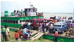
Fig 7.5 shows inland waterways widely used in the north-eastern states. The photograph is practical proof of the section’s claim: where big rivers and difficult terrain make roads costly, water transport is the everyday choice. The north-east appears again in the airways section for the same reason — difficult terrain needs the mode that fits it.
Other busy inland waterways not numbered as National Waterways are the Mandavi, Zuari and Cumberjua rivers, the Sunderbans, the Barak and the backwaters of Kerala (NCERT, p. 77).
For sea trade, remember the two numbers that travel together: 95% of India’s trade volume — 68% in terms of value — is moved by sea (NCERT, p. 77).
Major Sea Ports: A Tour of India’s Twelve Major Ports
A port is where sea trade touches the land. With a coastline of about 11,098.81 km, India has 12 major ports and 200 notified non-major ports, and the major ports handle 95% of India’s foreign trade (NCERT, p. 77).
Work down the west coast first, then the east coast, placing each port’s speciality as you go (NCERT, pp. 77-78):
| Port | Coast | Type | Speciality |
|---|---|---|---|
| Deendayal (Kandla), Gujarat | West | Tidal port | First port developed after Independence; eased pressure on Mumbai after the loss of Karachi; serves the granary-industrial belt of J&K, Himachal Pradesh, Punjab, Haryana, Rajasthan and Gujarat |
| Mumbai, Maharashtra | West | Natural, well-sheltered harbour | The biggest port |
| Jawaharlal Nehru, Maharashtra | West | — | Planned to decongest Mumbai; hub port for the region |
| Mormugao, Goa | West | — | Premier iron-ore exporting port; about 50% of India’s iron-ore export |
| New Mangalore, Karnataka | West | — | Exports iron-ore concentrates from the Kudremukh mines |
| Cochin, Kerala | West | Entrance of a lagoon, natural harbour | Extreme south-western port |
| V.O. Chidambaranar (Tuticorin), Tamil Nadu | East | Natural harbour | Extreme south-eastern port; rich hinterland; trade with Sri Lanka, the Maldives and coastal India |
| Chennai, Tamil Nadu | East | One of the oldest artificial ports | Ranked next to Mumbai in volume of trade and cargo |
| Vishakhapatnam, Andhra Pradesh | East | Deepest landlocked and well-protected port | Originally conceived as an outlet for iron-ore exports |
| Paradwip, Odisha | East | — | Specialises in the export of iron ore |
| Shyama Prasad Mookerjee, Kolkata | East | Inland riverine port; tidal | Serves the Ganga-Brahmaputra basin; requires constant dredging of the Hooghly |
| Haldia | East | Subsidiary port | Developed to relieve growing pressure on Kolkata port |
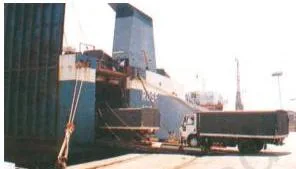
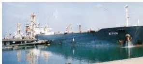
Three photographs show port activity in action. Fig 7.6 shows trucks being driven into a vessel at Mumbai port — cargo efficiency in one image. Fig 7.7 shows a tanker discharging crude oil at New Mangalore: India imports petroleum crude, and tanker unloading at ports like this feeds the import story in the trade section.
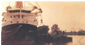
Fig 7.8 shows oversize cargo being handled at V.O. Chidambaranar (Tuticorin) — the large variety of cargoes its rich hinterland produces.
Airways and Communication: Fastest Travel and the Largest Postal Network
Air travel wins on speed and on terrain nothing else can cross; communication removes the need to travel at all. Both, in very different ways, bind the country together.
Airways
Air travel is the fastest, most comfortable and prestigious mode, covering high mountains, dreary deserts, dense forests and long oceanic stretches with ease. The north-eastern states depend on it: big rivers, dissected relief, dense forests, frequent floods and international frontiers make surface travel hard, and air travel has made access easier (NCERT, p. 78).
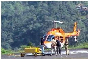
The aircraft in Fig 7.9 stands for the whole argument of the section: the chapter names air travel the fastest and most comfortable mode, and the figure gives that claim a picture.
- Pawanhans Helicopters Ltd provides helicopter services to the Oil and Natural Gas Corporation in its offshore operations, and to inaccessible areas and difficult terrains such as the north-eastern states and the interiors of Jammu and Kashmir, Himachal Pradesh and Uttarakhand (NCERT, p. 78).
- UDAN (Ude Desh ka Aam Nagrik) is a Regional Connectivity Scheme of the Ministry of Civil Aviation that makes flying affordable for the common citizen and encourages airlines to operate on regional and remote routes (NCERT, p. 78).
Communication: postal, telecom and mass media

The illustration on page 78 shows the long history its caption claims — humans have always communicated — but the pace of change has been rapid in modern times. Long-distance communication is now far easier without physical movement of the communicator or receiver (NCERT, p. 78).
Personal communication includes letters and calls; mass communication includes television, radio, press and films. The Indian postal network is the largest in the world, handling parcels and personal written communication (NCERT, p. 78).
- First-class mail — cards and envelopes — is airlifted between stations, covering both land and air.
- Second-class mail — book packets, registered newspapers and periodicals — is carried by surface mail, covering land and water transport.
- For quick delivery in large towns and cities, six mail channels have been introduced: Rajdhani, Metro, Green, Business, Bulk Mail and Periodical channels (NCERT, p. 78).
India has one of the largest telecom networks in Asia. More than two-thirds of villages, excluding urban places, have been covered with Subscriber Trunk Dialling (STD) telephone facility, and there is a uniform STD rate all over India, made possible by integrating space technology with communication technology (NCERT, p. 80).
The Digital India box adds the government’s goal: an umbrella programme to prepare India for a knowledge-based transformation, built on the idea that IT (Indian Talent) + IT (Information Technology) = IT (India Tomorrow) (NCERT, p. 80).
Mass media facts worth recalling: All India Radio (Akashwani) broadcasts in national, regional and local languages; Doordarshan is one of the largest terrestrial networks in the world; newspapers are published in about 100 languages and dialects, with the largest number in Hindi, followed by English and Urdu; India is the largest producer of feature films in the world; and the Central Board of Film Certification certifies both Indian and foreign films (NCERT, p. 80).
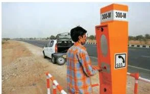
Fig 7.10 closes the loop between roadways and communication: an emergency call box on National Highway 48 is communication infrastructure placed on a road, letting a traveller in distress summon help without moving.
International Trade and Tourism as a Trade
Trade is exchange, and a country’s international trade is the thermometer of its economic health — the chapter calls it the economic barometer of a country (NCERT, p. 81).
Trade is the exchange of goods among people, states and countries, and the market is the place where such exchanges take place. International trade is trade between two countries, whether by sea, air or land routes. Local trade is carried in cities, towns and villages, while state-level trade is carried between two or more states (NCERT, pp. 80-81).
Because resources are space-bound, no country can survive without international trade, and the advancement of a country’s international trade is an index of its economic prosperity. Export and import are the two components of trade.
Balance of trade is the difference between a country’s exports and imports. When the value of exports exceeds the value of imports, it is a favourable balance of trade; when imports exceed exports, it is an unfavourable balance of trade (NCERT, p. 81).

The image on page 80 makes the scope of India’s trade visible in one frame: India has trade relations with all the major trading blocks and all geographical regions of the world (NCERT, p. 80). The commodities tell the same story:
| India’s exports | India’s imports |
|---|---|
| Gems and jewellery | Petroleum crude and products |
| Chemicals and related products | Gems and jewellery |
| Agriculture and allied products | Chemicals and related products |
| Base metals | |
| Electronic items | |
| Machinery | |
| Agriculture and allied products |
Add one modern chapter to the basket: India has emerged as a software giant at the international level and earns large foreign exchange through the export of information technology (NCERT, p. 80).
Tourism as a trade
Tourism has grown remarkably in India over the past two decades with government initiatives, infrastructure development and global branding. The schemes named in the chapter are Swadesh Darshan 2.0, Vibrant Village Programme, PRASHAD (Pilgrimage Rejuvenation and Spiritual Heritage Augmentation Drive) and Paryatan Mitra (NCERT, p. 81).
Tourism promotes national integration, supports local handicrafts and cultural pursuits, and develops international understanding of India’s culture and heritage. Foreign tourists visit India for heritage, eco, adventure, cultural, medical and business tourism, and there is vast potential for development of tourism in all parts of the country (NCERT, p. 81).
Reading the Chapter’s Figures and Maps
In this chapter the figures are evidence, not decoration — each photograph supports a claim in the text, and the two full-page maps are practice grounds for map pointing.
Here is what each figure is evidence for:
- Fig 7.1 (p. 71) — the lifelines montage: transport and communication as one system.
- Fig 7.2 (p. 72) — the Ahmedabad-Vadodara Expressway: the super highway project in operation.
- Border roads photo (p. 72), Fig 7.3 and Fig 7.4 (p. 74) — roads in hilly and border terrain.
- Railway network map (p. 74) — how physiographic, economic and administrative factors shape the network.
- Banihal-Baramula extension (p. 76) — railways entering the Himalayas.
- Fig 7.5 (p. 77) — inland waterways of the north-eastern states.
- Fig 7.6, Fig 7.7 and Fig 7.8 (pp. 77-78) — port operations: vehicles loaded into vessels, crude oil discharged, oversize cargo handled.
- Fig 7.9 and the communication image (p. 78) — air travel and the means of communication.
- Fig 7.10 (p. 80) — an emergency call box: communication placed on a road.
- Trade image (p. 80) — India’s relations with all major trading blocks and regions.
The two full-page maps
The book also carries two titled maps you should be able to name and read on an outline map of India: India: National Highways (p. 73) and India: Major Ports and Some International Airports (p. 79). The text explicitly asks you to look at the National Highways map and find out about the significant role played by these roads (NCERT, p. 72).
Map-pointing checklist
Before the exam, practise marking these on an outline map of India:
- the Golden Quadrilateral circuit cities: Delhi, Kolkata, Chennai, Mumbai;
- the four corridor terminals: Srinagar, Kanniyakumari, Silchar, Porbandar;
- the states named on the pipeline routes — Assam, Gujarat, Punjab and Uttar Pradesh — plus the branch towns;
- the five National Waterways and the rivers or canals they follow;
- the twelve major ports along the west and east coasts;
- the railway zone headquarters, from the page 74 activity.
Key Terms and Definitions in This Chapter
Several marks in this chapter depend on saying precisely what a term means rather than describing it loosely. These are the definitions the book uses:
| Term | Meaning (as the book uses it) | NCERT page | Where it tends to appear |
|---|---|---|---|
| Trade | Exchange of goods among people, states and countries | p. 81 | 30-word question 2(iv) |
| International trade | Trade between two countries | p. 81 | Multiple choice 1(vi) |
| Favourable balance of trade | Value of exports exceeds value of imports | p. 81 | Definition questions |
| Unfavourable balance of trade | Value of imports exceeds value of exports | p. 81 | Definition questions |
| Trans-shipment | Transfer of goods between vehicles; pipelines avoid its losses and delays | p. 75 | Multiple choice 1(ii) |
| Hinterland | The region served by a port | pp. 77-78 | Port questions |
| Tidal port | A port affected by tides; Deendayal is one, and Kolkata’s Hooghly needs constant dredging | pp. 77-78 | Port questions |
| Riverine port | A port located on a river, away from the open sea; Kolkata | p. 78 | Quiz Drive question 4 |
| Metalled roads | Made of cement, concrete or bitumen; all-weather roads | p. 74 | Short answers |
| Unmetalled roads | Go out of use in the rainy season | p. 74 | Short answers |
| Feeder transport | Transport that links other modes; roads link railway stations, airports and seaports | p. 72 | Merits of roadways |
Common Mistakes Students Make in This Chapter
This chapter’s marks are lost on recall slips, not on hard reasoning. Check these seven points before the exam:
| Mistake | Correct rule | How to check your answer |
|---|---|---|
| Reversing the balance of trade direction | Favourable = exports exceed imports; unfavourable = imports exceed exports (NCERT, p. 81) | Ask: is money flowing in or out? Exports bring money in, so they are favourable. |
| Mixing the sea-trade percentages | 95% is trade by volume; 68% is trade in value (NCERT, p. 77) | Say both numbers together with their labels — “95% volume, 68% value” — never separately. |
| Swapping the corridor terminals | North-South: Srinagar-Kanniyakumari; East-West: Silchar-Porbandar (NCERT, p. 72) | North-South spans the length of India; East-West the width. The East-West towns both end in “-ar”. |
| Confusing the road and rail superlatives | Roads: second largest network, about 62.16 lakh km (NCERT, p. 71). Railways: principal mode of transport (NCERT, p. 74) | The word “network” goes with roads; “principal mode” goes with railways. |
| Mixing up the port superlatives | Chennai: one of the oldest artificial ports. Mumbai: biggest port. Vishakhapatnam: deepest landlocked, well-protected port (NCERT, p. 78) | Test the adjective against the port: “biggest → Mumbai”, “deepest landlocked → Vishakhapatnam”. |
| Choosing rail for the trans-shipment question | Pipelines eliminate trans-shipment losses and delays (NCERT, p. 75) | Trans-shipment means transferring goods between vehicles; only a pipeline needs no transfer. |
| Treating metalled and unmetalled roads the same | Metalled roads are all-weather; unmetalled roads go out of use in the rainy season (NCERT, p. 74) | If the question mentions rain or seasons, the answer is metalled. |
The Chapter’s Five Activities and What They Teach
The five activities scattered through this chapter are not optional extras — each trains a skill the exercises test:
- Page 72 — web research: collect information on National Highway numbers (old and new) from the website, and identify which National Highway the historical Sher Shah Suri Marg between Delhi and Amritsar is.
- Page 74 — map work: find the current railway zones and their headquarters, and locate them on a map of India.
- Page 76 — map work: the railway line has been extended from Banihal to Baramula in the Kashmir Valley; locate both towns on a map of India.
- Page 81 — discussion and map work: show the tourist places of your state/UT and their connectivity by railways, roadways and airways; discuss what type of tourism your state could develop and how tourism can support economic development with a sustainable approach; prepare a project on heritage tourism.
- Page 83 — vocabulary: the word-search grid. Search vertically, horizontally or diagonally for transport terms; the grid hides entries like Sher Shah Suri Marg, Broad Gauge, Mughal Sarai, Kolkata and Chennai — the same vocabulary the Quiz Drive on page 82 questions.
How to Use This Chapter for Exam Preparation
The best practice for this chapter is the chapter’s own exercise set on pages 81-82. Here is what each question type demands.
Exercise 1: the multiple choice questions
These test factual recall of routes, modes and ports. Every answer is a fact stated in the chapter:
| Question | Answer | Why |
|---|---|---|
| 1(i) Extreme locations connected by the East-West corridor | (b) Silchar and Porbandar | The East-West corridor connects Silchar (Assam) and Porbandar (Gujarat) (NCERT, p. 72) |
| 1(ii) Mode that reduces trans-shipment losses and delays | (c) Pipeline | Pipelines rule out trans-shipment losses or delays (NCERT, p. 75) |
| 1(iii) State not connected with the HVJ pipeline | (b) Maharashtra | HVJ runs from Hazira (Gujarat) via Vijapur to Jagdishpur (Uttar Pradesh); among the options Maharashtra is not on this inland route (NCERT, p. 75) |
| 1(iv) Deepest landlocked and well-protected east-coast port | (d) Vishakhapatnam | Stated in the port section (NCERT, p. 78) |
| 1(v) Most important mode of transportation in India | (b) Railways | Railways are the principal mode of transportation for freight and passengers (NCERT, p. 74) |
| 1(vi) Trade between two or more countries | (b) International trade | Trade between two countries is international trade (NCERT, p. 81) |
Exercise 2: the 30-word answers
Thirty-word questions reward three clean points, not long sentences. Question 2(i) needs any three of the six merits of roadways listed above. Question 2(ii) needs a place and a reason: the northern plains, because of level land, high population density and rich agricultural resources (NCERT, p. 74).
Question 2(iii) needs the Border Roads Organisation’s role: strategic border roads, improved accessibility in difficult terrain, and economic development of these areas (NCERT, p. 72). Question 2(iv) needs the definition of trade first — the exchange of goods — then the scale difference: local trade within cities, towns and villages, international trade between countries (NCERT, p. 81).
Exercise 3: the 120-word answers
For 3(i), why transport and communication are called the lifelines of a nation and its economy, build the answer in five steps:
- Open with the definition: goods and services must move from supply locations to demand locations, and that movement is transport.
- Describe transport — land, water and air — as the physical movement of goods and people.
- Add communication — postal, telecom and mass media — which moves information without moving people.
- Add trade — exchange from local to international level — which completes the loop.
- Close on the book’s own conclusion: transport, communication and trade are complementary to each other (NCERT, p. 71); none works alone, and together they are the lifelines of the economy.
For 3(ii), the changing nature of international trade in the last fifteen years, structure the note around three changes: India’s export basket (gems and jewellery, chemicals, agriculture); the rise of India as a software giant earning large foreign exchange through IT exports; and trade relations with all major trading blocks and geographical regions, with 95% of trade volume moving by sea (NCERT, pp. 80, 77).
Quiz Drive: the chapter’s own revision quiz
The Quiz Drive on page 82 works as a self-test. Work through it, then check against the table:
| Clue | Answer | Where it is found |
|---|---|---|
| 1. Northern terminal of the North-South corridor | Srinagar | Corridor text, p. 72 |
| 2. Headquarters of the southern railway zone | Chennai | Word-search grid, p. 83 |
| 3. Rail gauge with a track width of 1.676 m | Broad gauge | Table 7.1, p. 74 |
| 4. A riverine port | Kolkata | Port section, p. 78 |
| 5. Busiest railway junction in northern India | Mughal Sarai | Word-search grid, p. 83 |
Notice how the word search on page 83 is the answer key for four of these five clues — Chennai, broad gauge, Kolkata and Mughal Sarai all hide in the grid.
One honest caveat: textbook contents and the examinable syllabus are not always identical. Check the current official CBSE syllabus for what is examinable this session.
The Whole Chapter in One Quick Scan
Two minutes before the paper — here is the entire chapter as scannable points, with page references:
- The lifelines idea (p. 71): transport + communication + trade are complementary; each fails without the others.
- Roads beat rail (pp. 71-72): lower construction cost, dissected terrain, higher gradients, short-distance economy, door-to-door service, feeder role.
- Six road classes (pp. 72-74): Golden Quadrilateral, National, State, District, Other (rural), Border roads.
- Corridors (p. 72): North-South Srinagar-Kanniyakumari; East-West Silchar-Porbandar; Golden Quadrilateral Delhi-Kolkata-Chennai-Mumbai-Delhi; implemented by NHAI.
- Atal Tunnel (p. 74): 9.02 km, built by BRO, Manali to Lahul-Spiti, Pir Panjal range.
- Rail (pp. 74-76): first train Mumbai-Thane 1853, 34 km; 17 zones; principal mode; broad gauge covers 63,950 of 67,956 route km.
- Three pipelines (pp. 75-76): upper Assam to Kanpur; Salaya to Jalandhar; HVJ gas pipeline 1,700 km, expanded to 18,500 km; no trans-shipment losses.
- Waterways (pp. 75, 77): cheapest mode; 111 National Waterways under the 2016 Act; five named NWs; sea moves 95% of trade volume (68% in value).
- Twelve ports (pp. 77-78): west — Deendayal (tidal, first after Independence), Mumbai (biggest), Jawaharlal Nehru (decongest Mumbai), Mormugao (iron ore, about 50%), New Mangalore (Kudremukh concentrates), Cochin (lagoon); east — Tuticorin (natural harbour), Chennai (oldest artificial), Vishakhapatnam (deepest landlocked), Paradwip (iron ore), Kolkata (riverine, dredging), Haldia (subsidiary).
- Air (p. 78): north-eastern states depend on air travel; Pawanhans; UDAN scheme.
- Communication (pp. 78-80): largest postal network; first-class airlifted vs second-class surface mail; six mail channels; STD in more than two-thirds of villages; AIR, Doordarshan, newspapers in about 100 languages, largest producer of feature films.
- Trade (pp. 80-81): trade is exchange; balance of trade = exports minus imports; favourable when exports exceed imports; export and import baskets; IT exports.
- Tourism (p. 81): Swadesh Darshan 2.0, Vibrant Village Programme, PRASHAD, Paryatan Mitra; heritage, eco, adventure, cultural, medical and business tourism.
Related Chapters and Resources
Chapter 7 is the closing chapter of NCERT’s Contemporary India – II, so it builds on the resource-based chapters of the same book — especially Chapter 6, Manufacturing Industries, which explains the industries whose goods these transport networks move.
For a full route through the subject, read the Manufacturing Industries Class 10 notes, browse the Class 10 Social Science notes, or go up to the Class 10 study hub and the CBSE notes index for every subject. The official NCERT chapter PDF and the NCERT website (ncert.nic.in) are the authoritative sources for the text.
Reference: NCERT Class 10 Contemporary India – II textbook, chapter 7, official edition on ncert.nic.in.
Sources and Data Verification
This page describes Chapter 7, Lifelines of National Economy, of NCERT’s Contemporary India – II (Class 10 Social Science), covering printed pages 70-83 of the official NCERT edition. It covers only this chapter — not the other Class 10 Social Science books and not the full CBSE scheme.
Textbook contents and the examinable syllabus are not always identical; check the current official CBSE syllabus for this session. NCERT settles textbooks, editions and PDFs; CBSE settles curriculum, syllabus and examinations. This listing is maintained for the current academic session using the NCERT information available to us, and it carries no external expert review process.
Frequently Asked Questions on This Chapter
Where can I download the Lifelines of National Economy Class 10 NCERT chapter PDF?
Use the download block at the top of this page. It links to the official PDF on ncert.nic.in (file jess107.pdf) — the exact text of the NCERT book Contemporary India – II, running from printed page 70 to page 83.
Which two extreme locations are connected by the East-West Corridor?
Silchar (Assam) and Porbandar (Gujarat). The North-South corridor, by contrast, connects Srinagar (Jammu & Kashmir) with Kanniyakumari (Tamil Nadu) (NCERT, p. 72).
Which port is the deepest landlocked and well-protected port along the east coast?
Vishakhapatnam. It was originally conceived as an outlet for iron-ore exports, and it is also exercise question 1(iv) (NCERT, p. 78).
What is the difference between favourable and unfavourable balance of trade?
Balance of trade is exports minus imports. When exports exceed imports the balance is favourable; when imports exceed exports it is unfavourable (NCERT, p. 81).
Why does road transport have an edge over rail transport in India?
For six reasons: lower construction cost, ability to cross dissected and undulating terrain, ability to climb higher gradients, economy over short distances, door-to-door service, and a feeder role linking railway stations, airports and seaports (NCERT, pp. 71-72).
How many National Waterways were declared under the National Waterways Act 2016?
111 inland waterways were declared National Waterways, including 5 declared earlier. NW1 (Ganga, Prayagraj-Haldia) is the longest at 1,620 km (NCERT, p. 75).
Explore Class 10 Social Science Books
Class 10 Social Science on LearnCBSE:
Related chapters:
- Resources and Development
- Power-sharing
- The Rise of Nationalism in Europe