
These Water in the Atmosphere Class 11 notes condense Chapter 10 of NCERT Fundamentals of Physical Geography (pages 86-90) into revision-ready form. The chapter follows one continuous chain: moisture enters the air by evaporation and transpiration, is measured as humidity, condenses into dew, frost, fog and clouds, and finally falls as precipitation whose types and world distribution close the story.
These notes follow the rationalised NCERT textbook for the 2026-27 session and form part of the Class 11 Geography notes collection. You can also browse the wider Class 11 notes hub or start from the main CBSE notes library.
Every section points to its textbook pages, and each definition can be verified in the official NCERT PDF of the chapter (pages 86-90) hosted at ncert.nic.in.
The Moisture Cycle: Chapter 10 at a Glance
The chapter is the journey of water through the lower atmosphere, and every idea in it belongs to one link of this chain:
- Source of vapour — evaporation from water bodies and transpiration from plants keep moisture moving into the air (NCERT, p. 86).
- Humidity measures — the vapour present in air is expressed as absolute and relative humidity (NCERT, p. 86).
- Saturation and dew point — air that can hold no more moisture is saturated, and the temperature at which saturation occurs is the dew point (NCERT, p. 86).
- Condensation and its forms — dew, frost, fog and clouds (NCERT, pp. 87-88).
- Precipitation — rain, snow, sleet and hail release the condensed moisture (NCERT, p. 88).
- Rainfall types and world distribution — convectional, orographic and cyclonic rain, and the global patterns of rainfall (NCERT, pp. 88-89).
One cross-reference matters: the book does not re-explain cyclonic rain here — it directs you to Chapter 9, where extra-tropical cyclones and cyclonic rain are treated (NCERT, p. 89). The exercise set for this chapter sits on page 90.
Key Definitions: Humidity, Saturation, Dew Point and Precipitation
Every later section builds on these terms, so read this table once and return to it while doing the exercises. A complete answer to a definition question starts from exactly these meanings.
| Term | Meaning | Example or clue |
|---|---|---|
| Humidity | Water vapour present in the air | The wetness you feel on a humid day |
| Absolute humidity | The actual amount of water vapour in the atmosphere — the weight of vapour per unit volume of air | Expressed in grams per cubic metre (g/m3) |
| Relative humidity | The percentage of moisture present compared with the air’s full capacity at a given temperature | If air holds 8 of its 20 g/m3 capacity, relative humidity is 40 per cent |
| Saturated air | Air holding moisture to its full capacity at a given temperature, unable to hold any more | Any extra vapour must condense |
| Dew point | The temperature at which saturation occurs in a given sample of air | Cool the air to this temperature and condensation begins |
| Evaporation | The process by which water changes from liquid to gaseous state; heat is the main cause | Clothes dry faster in the sun |
| Latent heat of vaporisation | The heat energy required to convert a unit mass of liquid into vapour without a change in temperature | Energy absorbed during evaporation, released during condensation |
| Condensation | The transformation of water vapour into water, caused by loss of heat | Water drops on a cold drink can |
| Hygroscopic condensation nuclei | Tiny particles that absorb water — dust, smoke, ocean salt — around which condensation takes place | Fog forms around dust nuclei |
| Precipitation | The release of moisture after condensation, in liquid or solid form | Rain, snow, sleet and hail |
| Rain-shadow area | The drier leeward side of a mountain that receives less rainfall | The dry side behind a coastal range |
All definitions above follow the chapter’s own scope — humidity terms on page 86, condensation forms on page 87, precipitation on page 88 and the rain-shadow idea on page 89.
Key Numbers and Units to Memorise
The chapter has no equations, so its quantities are the figures a complete short answer expects — they belong to memory.
| Quantity | Value and meaning |
|---|---|
| Water vapour share of the atmosphere | Zero to four per cent by volume (NCERT, p. 86) |
| Unit of absolute humidity | Grams per cubic metre (g/m3) — weight of vapour per unit volume of air (NCERT, p. 86) |
| Cirrus cloud altitude | 8,000-12,000 m (NCERT, p. 87) |
| Cumulus cloud altitude | 4,000-7,000 m (NCERT, p. 87) |
| Fog visibility limit | Below 1 km (NCERT, p. 87) |
| Mist visibility range | Between 1 km and 2 km (NCERT, p. 87) |
| Frost freezing point | 0°C — frost needs the dew point at or below freezing (NCERT, p. 87) |
| Heavy rainfall regime | Above 200 cm per year (NCERT, p. 89) |
| Moderate rainfall regime | 100-200 cm per year (NCERT, p. 89) |
| Low rainfall regime | 50-100 cm per year (NCERT, p. 89) |
| Very low rainfall regime | Below 50 cm per year (NCERT, p. 89) |
Humidity, Evaporation and Condensation: What Controls Moisture in Air
Temperature rules everything. The ability of air to hold water vapour depends entirely on its temperature (NCERT, p. 86). That single idea explains why absolute humidity differs from place to place, why relative humidity changes when air warms or cools, and why vapour content falls with altitude.
Evaporation adds moisture. Heat is its main cause, and latent heat of vaporisation is the heat energy needed to convert a unit mass of a liquid into vapour without a change in temperature (NCERT, p. 86). Evaporation rises with three conditions:
- higher temperature, which raises the air’s capacity to hold vapour;
- low existing moisture, because dry air can still absorb more;
- movement of air, which replaces the saturated layer with an unsaturated one — the greater the movement of air, the greater the evaporation.
The vapour source is the ocean and other water bodies described in the water in the oceans chapter notes, and the air that receives it is the layered envelope covered in the composition and structure of the atmosphere notes.
Condensation removes moisture. It is the reverse — the transformation of water vapour into water, caused by loss of heat. In free air, condensation takes place around hygroscopic condensation nuclei: dust, smoke and salt from the ocean are good nuclei because they absorb water (NCERT, p. 86).
Condensation also occurs when moist air touches a colder object, and its amount depends on the degree of cooling and the relative humidity of the air.
Condensation happens under three conditions:
- the temperature of the air is reduced to the dew point with its volume remaining constant;
- both the volume and the temperature are reduced;
- moisture is added to the air through evaporation.
The most favourable condition for condensation is a decrease in air temperature (NCERT, p. 87). That is why the real-life hook below works: a weather app shows tonight’s low along with the dew point.
If the night low approaches the dew point, you can predict morning dew when the dew point stays above freezing, frost when it touches freezing, and fog when a moist air mass cools suddenly — the chapter working outside the exam hall.
Forms of Condensation: Dew, Frost, Fog and Mist
After condensation, moisture takes the forms of dew, frost, fog and clouds (NCERT, p. 87). The decisive question for each near-ground form is whether the dew point lies above or at/below the freezing point.
| Form | Where it forms | Key condition | Ideal conditions |
|---|---|---|---|
| Dew | Water droplets on cooler surfaces of solid objects — stones, grass blades, plant leaves | Dew point above the freezing point | Clear sky, calm air, high relative humidity, cold and long nights |
| Frost | Minute ice crystals on cold surfaces, instead of droplets | Dew point at or below the freezing point (0°C) | Same as dew, except the air temperature must be at or below freezing |
| Fog | A cloud with its base at or very near the ground; a moist air mass cools suddenly on fine dust particles | Sudden cooling of a moist air mass; common where warm and cold currents meet | Plenty of nuclei — in cities smoke supplies them; fog reduces visibility below 1 km |
| Mist | Like fog, but each nucleus carries a thicker layer of moisture | Rising warm air up mountain slopes meets a cold surface | Frequent over mountains; mist limits visibility to between 1 km and 2 km |
| Smog | Fog mixed with smoke | Fog formation plus smoke in the air | Urban and industrial centres |
Memory device for dew’s ideal conditions: the three Cs and one H — Clear sky, Calm air, Cold and long nights, High relative humidity. And the easiest detail to mix up is visibility: fog cuts visibility below 1 km; mist allows 1-2 km (NCERT, p. 87).
Cloud Types and How to Identify Them
A cloud is a mass of minute water droplets or tiny ice crystals formed by condensation of water vapour in free air at considerable elevations (NCERT, p. 87). Clouds take different shapes according to their height, expanse, density and transparency, which is why the four basic types look so different:
- Cirrus — formed at high altitudes (8,000-12,000 m); thin and detached clouds with a feathery appearance, always white (NCERT, p. 87).
- Cumulus — look like cotton wool, formed at 4,000-7,000 m; exist in patches scattered here and there, with a flat base (NCERT, p. 87).
- Stratus — layered clouds covering large portions of the sky, formed by loss of heat or by mixing of air masses of different temperatures (NCERT, p. 87).
- Nimbus — black or dark grey, shapeless, extremely dense and opaque to the sun; forms at middle levels or very near the surface, sometimes seeming to touch the ground (NCERT, p. 88).
Memory device for the four, in order: Clever Children Study Nicely — Cirrus, Cumulus, Stratus, Nimbus.
Combinations of the four basic types give the cloud families: high clouds (cirrus, cirrostratus, cirrocumulus), middle clouds (altostratus, altocumulus), low clouds (stratocumulus, nimbostratus) and clouds with extensive vertical development (cumulus, cumulonimbus) (NCERT, p. 88).
The chapter’s own question asks you to identify the cloud types shown in Figures 10.1 and 10.2. The two figures are placed here so you can practise with the same tools the textbook gives you:
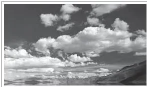
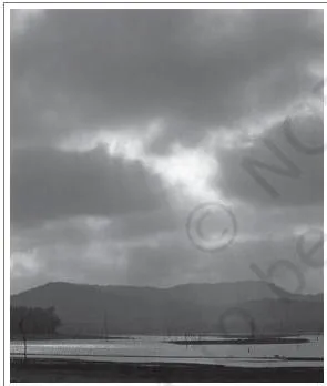
Apply three criteria in order, and the identification follows:
- Height — judge whether the clouds sit high, middle or near the ground; cirrus is the highest, nimbus can seem to touch the ground.
- Shape — feathery (cirrus), cotton-wool patches with a flat base (cumulus), layered sheets (stratus) or shapeless masses (nimbus).
- Colour — white (cirrus, cumulus) versus black or dark grey (nimbus).
Running these three checks over what the figures show is the skill the exercise is testing, and the same criteria work on any sky scene you meet.
Precipitation: Rain, Snow, Sleet and Hail
The mechanism is simple: continuous condensation in free air makes condensed particles grow until the resistance of the air can no longer hold them against the force of gravity. When they fall, the release of moisture is called precipitation, in liquid or solid form (NCERT, p. 88).
- Rainfall — precipitation in the form of water, the ordinary form.
- Snowfall — occurs when the temperature is lower than 0°C; moisture is released as hexagonal crystals that form flakes of snow (NCERT, p. 88).
- Sleet — frozen raindrops and refrozen melted snow-water. A layer of air above freezing overlies a subfreezing layer near the ground; raindrops leaving the warmer air solidify in the colder air below and reach the ground as small pellets of ice no bigger than the original raindrops (NCERT, p. 88).
- Hail — raindrops solidify into small rounded solid pieces of ice while passing through colder layers; these hailstones show several concentric layers of ice, one over the other (NCERT, p. 88).
Rainfall and snowfall are the main forms; sleet and hail are limited in occurrence and sporadic in both time and space (NCERT, p. 88). The two are easy to conflate, so keep the contrast straight:
| Aspect | Sleet | Hail |
|---|---|---|
| Formation setting | Warm layer above a subfreezing ground layer | Raindrops passing through colder layers |
| Size | Small pellets no bigger than the raindrops | Small rounded solid pieces of ice |
| Internal structure | Solid frozen pellets | Several concentric layers of ice, one over the other |
Types of Rainfall: Convectional, Orographic and Cyclonic
On the basis of origin, rainfall is of three main types. Each starts from a different trigger that lifts moist air and cools it to the dew point (NCERT, p. 88).
Convectional rain. Air heated near the ground becomes light and rises in convection currents. As it rises, it expands and loses heat, condensation takes place and cumulus clouds form. The rainfall is heavy, with thunder and lightning, but it does not last long.
It is common in summer or in the hotter part of the day, and very common in equatorial regions and the interiors of continents, particularly in the northern hemisphere (NCERT, pp. 88-89).
Orographic (relief) rain. When a saturated air mass comes across a mountain, it is forced to ascend; it expands, its temperature falls and moisture condenses. The windward slopes receive greater rainfall.
After giving rain on the windward side, the winds descend on the other slope, their temperature rises and their capacity to take in moisture increases — so the leeward slopes stay dry. This drier area is the rain-shadow area (NCERT, p. 89).
Cyclonic (frontal) rain. The book does not re-explain it here: it directs you to Chapter 9, where extra-tropical cyclones and cyclonic rain are treated. In brief, cyclonic rain is associated with the convergence and uplift of air around cyclones.
| Type | Trigger | Where it is common | Character of the rain |
|---|---|---|---|
| Convectional | Ground air heated, rises in convection currents, expands and cools | Equatorial regions, interiors of continents (especially northern hemisphere); summer or the hotter part of the day | Heavy, with thunder and lightning, but short-lived |
| Orographic (relief) | Saturated air forced to ascend over a mountain, cools and condenses | Windward slopes of mountain ranges; coastal plains when ranges run parallel to the coast | Greater rainfall on the windward side; leeward slopes lie in a rain-shadow area |
| Cyclonic (frontal) | Convergence and uplift of air around cyclones | Explained in Chapter 9 for extra-tropical cyclones | The book directs the full treatment to Chapter 9 |
World Distribution of Rainfall: Patterns and Regimes
The distribution of rainfall follows a few consistent rules (NCERT, p. 89):
- As we proceed from the equator towards the poles, rainfall goes on decreasing steadily.
- Coastal areas of the world receive greater rainfall than the interiors of continents.
- Rainfall is more over the oceans than over landmasses, because oceans are great sources of water.
- Between 35° and 40° N and S, rain is heavier on the eastern coasts and decreases towards the west.
- Between 45° and 65° N and S, under the westerlies, rainfall is first received on the western margins of the continents and decreases towards the east.
- Where mountains run parallel to a coast, the coastal plain and the windward side get more rain, and it decreases towards the leeward side.
On the basis of the total annual precipitation, four major precipitation regimes are identified (NCERT, p. 89):
| Annual rainfall | Where it occurs |
|---|---|
| Above 200 cm | Equatorial belt; windward slopes of mountains along the western coasts in the cool temperate zone; coastal areas of the monsoon lands |
| 100-200 cm | Interior continental areas |
| 50-100 cm | Central parts of the tropical lands; eastern and interior parts of the temperate lands |
| Below 50 cm | Rain-shadow zones of the interior of the continents; high latitudes |
Seasonal distribution matters too: in the equatorial belt and in the western parts of the cool temperate regions, rainfall is distributed evenly through the year (NCERT, p. 89).
Worked Examples: Humidity Calculations and Rainfall Reasoning
The NCERT chapter carries no worked numericals, so the four examples below use original numbers to show how the definitions work in practice. Each method is named first, then the steps; units appear at every step.
Worked Example 1: Calculate relative humidity
Method: Relative humidity is the actual moisture present divided by the air’s full capacity at that temperature, multiplied by 100.
Step 1: Write the given values.
Air at a certain temperature holds 8 grams of water vapour per cubic metre, while the same air could hold 20 grams per cubic metre.
\[ \text{Relative humidity} = \frac{8}{20} \times 100 \]
\[ = 0.4 \times 100 = 40\% \]
Final answer: The relative humidity is 40 per cent.
Worked Example 2: Find actual moisture from relative humidity
Method: Actual moisture equals relative humidity multiplied by the full capacity, with the percentage written as a decimal.
Step 1: Morning air shows 75 per cent relative humidity, and the capacity at the morning temperature is 12 grams per cubic metre.
\[ \text{Actual moisture} = 0.75 \times 12 = 9\ \text{g/m}^3 \]
Final answer: The air actually holds 9 grams of water vapour per cubic metre.
Worked Example 3: Identify the rainfall type behind a mountain gap
Method: Match the clues — a mountain range, a wet windward slope and a dry leeward slope — against the three rainfall types.
Step 1: A coastal range receives 260 cm of rain a year on its windward slope, while a town on the leeward side receives 45 cm.
The trigger is the mountain barrier, so the type is orographic or relief rain.
Step 2: Explain the gap.
Saturated air is forced up the mountain, cools and rains on the windward slope (NCERT, p. 89).
After that, the air descends, warms and gains a higher capacity to hold moisture, so little rain falls on the leeward side — the town lies in a rain-shadow area.
Final answer: Orographic rain; the 215 cm difference between the slopes is the rain-shadow effect of descending, warming air.
Worked Example 4: Decide between dew and frost from the dew point
Method: Compare the night’s dew point with the freezing point, 0°C — above freezing gives dew, at or below gives frost.
Step 1: First night — the dew point is \( 4^\circ\text{C} \) and the ground cools to \( 1^\circ\text{C} \).
The dew point is above the freezing point, so moisture deposits as water droplets: dew.
Step 2: Second night — the dew point falls to \( -2^\circ\text{C} \), at or below \( 0^\circ\text{C} \).
Moisture deposits as minute ice crystals: frost.
Final answer: First night — dew; second night — frost.
Same logic for sleet and hail: check the layering of air temperature.
A warm layer above a subfreezing ground layer produces sleet; raindrops passing through colder layers produce hailstones with concentric layers of ice.
Common Mistakes: Fog vs Mist, Sleet vs Hail and Other Mix-Ups
These are the chapter-specific confusions students most often carry into exercises. Each row follows the pattern: the wrong claim, the correct rule, and a check you can run on your own answer.
| Mistake | Correct rule | How to check your answer |
|---|---|---|
| Fog holds more moisture than mist. | Mist holds more moisture, because each mist nucleus carries a thicker layer of moisture; fogs are drier. The visibility contrast is the landmark: fog below 1 km, mist between 1 km and 2 km (NCERT, p. 87). | Ask which form is drier — if you wrote fog, flip it. |
| Nimbus is the highest cloud. | Cirrus is the highest, at 8,000-12,000 m; nimbus forms at middle levels or very near the surface (NCERT, pp. 87-88). | Recall the altitude list: cirrus first at 8,000-12,000 m, cumulus at 4,000-7,000 m. |
| Frost is dew that has frozen. | Frost forms directly as minute ice crystals when the dew point is at or below 0°C; dew requires the dew point above the freezing point (NCERT, p. 87). | Compare the dew point with 0°C — above means dew, at or below means frost. |
| Hail is large sleet. | Sleet is frozen raindrops from a warm layer over a subfreezing ground layer, no bigger than the original raindrops. Hail builds rounded pieces of ice with concentric layers as raindrops pass through colder layers (NCERT, p. 88). | Look for structure — concentric layers of ice mean hail. |
| Absolute and relative humidity are interchangeable. | Absolute humidity is the weight of vapour per unit volume (g/m3); relative humidity is the percentage of full capacity at a given temperature, and capacity itself changes with temperature (NCERT, p. 86). | Check the unit — grams per cubic metre versus per cent. |
| The leeward side is dry because it has no moisture. | The leeward air has descended, warmed and gained capacity to hold moisture, so it stops releasing rain — the rain-shadow effect (NCERT, p. 89). | Ask: would warming raise or lower the air’s capacity? Warming raises it, so no rain. |
Exam Notes: Structuring the Page 90 Exercise Answers
The page 90 exercise set has four objective questions, four short answers of about 30 words and two longer answers of about 150 words. These skeletons show what a complete answer contains; every definition used here is grounded in the chapter pages above.
The four objective questions
Each objective item needs the correct option plus a one-line reason:
- (i) Oxygen — this is a judgement drawn from general knowledge, not from the chapter text: humans depend on oxygen for respiration, while the chapter values water vapour for its role in weather phenomena.
- (ii) Evaporation — it is the process that changes liquid water into vapour (NCERT, p. 86).
- (iii) Saturated air — air that holds moisture to its full capacity at a given temperature (NCERT, p. 86).
- (iv) Cirrus — the highest cloud, at 8,000-12,000 m (NCERT, p. 87).
Short answers — about 30 words each
- Three types of precipitation: rainfall, snowfall and sleet; hail is a fourth form, limited and sporadic in occurrence (NCERT, p. 88).
- Relative humidity: definition (the percentage of moisture present compared with the air’s full capacity at a given temperature) plus one worked observation, such as air holding 8 of its 20 g/m3 capacity giving 40 per cent (NCERT, p. 86).
- Water vapour and altitude: temperature falls with altitude, and with it the air’s capacity to hold vapour falls, so the amount of water vapour decreases rapidly (NCERT, p. 86).
- Cloud formation and classification: condensation of water vapour in free air around hygroscopic nuclei (NCERT, p. 87); classify as the four basic types (cirrus, cumulus, stratus, nimbus) and the combined families of high, middle, low and vertically developed clouds (NCERT, p. 88).
Long answers — about 150 words each
- World distribution of precipitation: open with the decrease from the equator towards the poles; then coastal versus interior and oceans versus land; then the 35°-40° belt rule (heavier on eastern coasts) and the 45°-65° westerlies rule (rain first received on western margins); then mountain effects; and close with the four regimes by annual amount and the even seasonal distribution of the equatorial belt and the west of the cool temperate regions (NCERT, p. 89).
- Forms of condensation: open with what condensation is — the transformation of water vapour into water by loss of heat; state the dew point versus freezing point relationship; then describe dew (water droplets on cooler surfaces, ideal conditions of clear sky, calm air, high humidity and cold nights) and frost (minute ice crystals, dew point at or below 0°C) (NCERT, p. 87).
One line of project support: tracking newspaper reports of extreme rainfall from 1 June to 31 December (the chapter’s project work, NCERT, p. 90) is a practical way to recognise orographic and cyclonic rain in the news.
These are revision notes, not an answers key — the skeletons above give the shape of a complete answer to the book’s own exercises, and each definition can be checked against the official NCERT PDF of the chapter.
Quick Revision Recap: The Chapter in One Page
The whole chapter is one moisture chain. Each link below carries its textbook page so you can go back to the source in seconds:
- Evaporation from water bodies + transpiration from plants — p. 86
- Humidity: absolute and relative — p. 86
- Saturation at the dew point — p. 86
- Condensation around hygroscopic nuclei — p. 86
- Forms of condensation: dew, frost, fog, mist, clouds — pp. 87-88
- Precipitation: rainfall, snowfall, sleet, hail — p. 88
- Rainfall types: convectional, orographic, cyclonic — pp. 88-89
- World distribution patterns and regimes — p. 89
Finally, the pairs that are easiest to invert, side by side:
| Pair | The contrast |
|---|---|
| Dew vs frost | Dew point above vs at or below freezing |
| Fog vs mist | Visibility below 1 km vs 1-2 km; fog drier, mist wetter |
| Sleet vs hail | Warm layer over a cold ground layer vs raindrops passing through colder layers |
| Absolute vs relative humidity | Weight in g/m3 vs percentage of capacity |
| Windward vs leeward | Rainy vs rain-shadow |
| Cirrus vs nimbus | Highest, feathery, white vs low, dark, shapeless |
Frequently Asked Questions
What is the difference between dew and frost?
Both form on cold surfaces at night, but the dew point decides which one appears. Dew forms as water droplets when the dew point is above the freezing point; frost forms as minute ice crystals when the dew point is at or below 0°C (NCERT, p. 87).
Why does the amount of water vapour decrease rapidly with altitude?
Because the ability of air to hold water vapour depends entirely on its temperature (NCERT, p. 86). Temperature falls with altitude, so the air’s capacity to hold vapour falls with it, and the actual vapour content drops rapidly.
Which has more moisture, fog or mist?
Mist. In mist each nucleus carries a thicker layer of moisture, so mist contains more moisture than fog, and fogs are drier (NCERT, p. 87). The other clear difference is visibility: fog reduces it to below 1 km, mist to between 1 km and 2 km.
Why does the leeward side of a mountain receive less rainfall?
After giving rain on the windward slopes, the air descends on the leeward side, its temperature rises and its capacity to hold moisture increases, so condensation stops and the slopes stay dry (NCERT, p. 89). This drier area is the rain-shadow area.
What are the four types of clouds and at what heights do they form?
Cirrus (8,000-12,000 m), cumulus (4,000-7,000 m), stratus (layered, covering large sky portions) and nimbus (at middle levels or very near the surface) (NCERT, pp. 87-88). Combinations of these four give the high, middle, low and vertically developed cloud families.
How are sleet and hail formed, and how do they differ?
Sleet is frozen raindrops: a warm air layer over a subfreezing ground layer makes raindrops solidify into tiny ice pellets no bigger than the original drops. Hail forms when raindrops pass through colder layers and solidify into rounded pieces of ice with several concentric layers, one over the other (NCERT, p. 88).
Reference: NCERT Class 11 Geography textbook (Fundamentals of Physical Geography), Chapter 10, Water in the Atmosphere.
Explore Class 11 Geography Notes
- Class 11 Geography Notes
- Class 11 CBSE Notes
- CBSE Notes for Classes 1 to 12
- Previous: Composition and Structure of Atmosphere
- Next: Water (oceans)
Class 11 Geography on LearnCBSE:
Related chapters:
- Landforms and Their Evolution notes