
A landform is a small to medium sized tract or parcel of the earth’s surface, and several related landforms together make up a landscape (NCERT, p. 47). This chapter follows five groups of geomorphic agents – running water, groundwater, glaciers, waves and currents, and wind – as they erode the land and then build new forms by deposition.
Every landform has a beginning, and a landmass passes through stages comparable to the stages of life: youth, mature and old age (p. 47).
These notes follow the 2026-27 session (Rationalised NCERT). They give you the whole chapter in one-sitting revision form: definitions, comparison tables, all 14 chapter figures with readings, worked identifications, common mistakes, and answer structure for the textbook’s own questions. You can verify any passage or figure directly in the official NCERT PDF of Class 11 Fundamentals of Physical Geography (Chapter 6).
These notes are part of the CBSE notes library.
How This Chapter Builds: Agents, Erosion, Deposition and Stages
Erosion and deposition are partners. Weathering prepares loose material, geomorphic agents erode it, and deposition follows erosion – both processes change the earth’s surface (p. 47). Evolution here means the stages of transformation of a landform, or of a part of the earth’s surface, once it has been formed.
Changes in climate or vertical and horizontal movements of landmasses can change the intensity of the processes, so a landform keeps evolving (p. 47). The material itself is prepared by weathering – revise Chapter 5, Geomorphic Processes, in the Class 11 Geography notes hub.
The chapter opens by asking what the two important aspects of landform evolution are. Keep two ideas ready: (1) erosion, followed by deposition, changes the surface; and (2) a landmass passes through youth, mature and old stages (p. 47). The five agents do not work everywhere equally, so NCERT treats each one separately.
The master table below gathers the forms each agent makes – this is the whole chapter in one view.
| Agent | Where it dominates | Key erosional landforms | Key depositional landforms | Indian example in the textbook |
|---|---|---|---|---|
| Running water | Humid regions | V-shaped valleys, gorges, canyons, potholes, plunge pools, incised meanders, river terraces | Alluvial fans, deltas, floodplains, natural levees, point bars, oxbow lakes | Kaveri gorge, Amarnath fan, Krishna delta, Burhi Gandak oxbows |
| Groundwater | Limestone and dolomite (karst) regions | Swallow holes, sinkholes, uvalas, lapies, limestone pavements, caves and tunnels | Stalactites, stalagmites, columns and pillars | – |
| Glaciers | High mountains and cold regions | Cirques, horns, arêtes, U-shaped glacial troughs, fjords | Glacial till, outwash deposits, moraines, eskers, outwash plains, drumlins | Gangotri and Alkapuri glaciers feeding the Bhagirathi and Alaknanda |
| Waves and currents | Coasts | Cliffs, wave-cut platforms, sea caves, sea stacks | Wave-built terraces, beaches, bars, barrier bars, spits, lagoons, coastal plains, beach dunes | West coast (rocky) vs east coast (sedimentary); Godavari spit |
| Wind | Hot deserts | Pediments, inselbergs, pediplains, deflation hollows, blow outs and caves, mushroom/table/pedestal rocks | Playa lakes and alkali flats, sand dunes of all types | – |
Because erosion intensity can change with climate and landmass movements, no landform is permanent – the textbook’s point in calling the chapter an evolution, not a description (p. 47).
Running Water: Landforms of Rivers
The Three Stages of a River’s Life
In humid regions, running water is the most important agent of degradation. It works in two ways: overland flow as a sheet and linear flow as streams and rivers in valleys (p. 47). As a channel gentles through continued erosion, down-cutting becomes less dominant and lateral erosion of banks increases, so hills and valleys are gradually reduced to plains (pp. 47-48).
The three stages describe that reduction.
| Feature | Youth | Mature | Old |
|---|---|---|---|
| Streams | Few, poorly integrated, flowing over original slopes | Plenty, well integrated | Few small tributaries with gentle gradients |
| Valleys | Shallow V-shaped | Deep but still V-shaped | Free meandering over vast floodplains |
| Floodplains | None, or very narrow along trunk streams | Wider, with meanders confined within the valley | Vast floodplains with natural levees and oxbow lakes |
| Divides | Broad and flat, with marshes, swamps and lakes | Sharp | Broad and flat, with lakes, swamps and marshes |
| Waterfalls and rapids | Present where hard rocks are exposed | Disappear | Absent; most land is at or slightly above sea level |
The end product of stream erosion is a peneplain (an almost plain), with low resistant remnants called monadnocks standing out here and there (p. 48).
Erosional Valley Forms
Valleys begin small. Overland flow concentrates into paths, forms small narrow rills, then long wide gullies; gullies deepen, widen, lengthen and unite into a network of valleys (p. 48). The shape and size of the valley depend on the rock it cuts into.
| Feature | Gorge | Canyon |
|---|---|---|
| Side slopes | Very steep to straight | Steep, step-like side slopes |
| Width | Almost equal at top and bottom | Wider at top than at bottom |
| Relation | The basic form | A variant of gorge |
| Rock type | Hard rocks | Horizontal bedded sedimentary rocks |
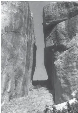
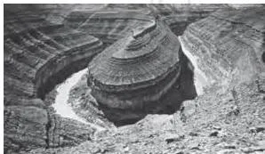
Figure 6.1, the valley of the Kaveri near Hogenekal, shows the near-vertical straight sides that define a gorge. Figure 6.2 shows an entrenched meander loop of the Colorado – its step-like side slopes are the diagnostic signs of a canyon (p. 49).
- Potholes are circular depressions over the rocky beds of hill-streams. Pebbles and boulders collect in a small depression, rotate with flowing water, and gradually enlarge it (pp. 48-49).
- Plunge pools are large, deep potholes at the foot of waterfalls, formed by the sheer impact of falling water plus the rotation of boulders (p. 49).
- Incised or entrenched meanders are very deep and wide meanders cut into hard rock – Figure 6.2 is the textbook’s example (p. 49).
- River terraces are surfaces marking old valley floor or floodplain levels. They may be bedrock surfaces or alluvial terraces; when they occur at the same elevation on both sides, they are paired terraces (p. 49).
Depositional Forms: Fans, Deltas and Floodplains
Deposition builds a floodplain just as erosion makes valleys. Fine sand, silt and clay are carried to gentler channels and spread over the bed; when water spills over the banks during floods, the floodplain above the bank receives its deposits (p. 50).
- Active floodplain – the river bed made of river deposits, below the bank.
- Inactive floodplain – above the bank, containing flood deposits (silt and clay) and coarse channel deposits of abandoned cut-off channels.
- Delta plains – the floodplains of a delta (p. 50).
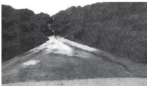
When a mountain stream breaks onto a low-gradient foot slope, its very coarse load is dumped as a cone-shaped alluvial fan. Streams over fans are not confined to one channel; they shift across the fan, forming distributaries. Fans are low and gentle in humid areas, but high and steep in arid and semi-arid climates (pp. 49-50).
Figure 6.3 shows an alluvial fan deposited by a hill stream on the way to Amarnath.
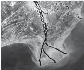
Deltas form where the river’s load is dumped into the sea instead of being carried far away or along the coast. Unlike fans, delta deposits are well sorted with clear stratification: the coarsest materials settle first, while silts and clays are carried out to sea. As the delta grows, distributaries lengthen and the delta builds seaward (p. 50).
Figure 6.4, a satellite view of part of the Krishna delta, shows the distributaries extending into the sea.
Natural levees and point bars are important landforms found with floodplains. Levees are low, linear, parallel ridges of coarse deposits along the banks of large rivers. Point bars (also called meander bars) are almost uniform, linear deposits of mixed sediment sizes laid along meander banks (pp. 50-51). Figure 6.5 sets the two forms side by side.
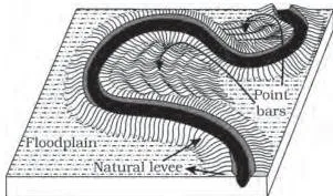
Wording caution: the textbook’s point-bar sentence places point bars on the concave side of meanders (p. 51), but its own meander description says deposition is active along the convex bank (p. 51). See the Common Mistakes section for how to handle this mismatch.
Meanders and Oxbow Lakes
A meander is a channel pattern, not a landform. It is the loop-like course a river takes over flood and delta plains where gradients are very gentle (p. 51). NCERT gives three causes:
- water over very gentle gradients tends to work laterally on the banks;
- unconsolidated alluvial banks carry irregularities on which water can exert lateral pressure;
- the Coriolis force deflects the flowing water, just as it deflects wind (p. 51).
A slight irregularity along a bank deepens into a curvature. Deposition builds the inside of the curve – the convex bank, called the slip-off side, with a long gentle profile – while erosion undercuts the concave bank, called the cut-off bank, which shows a steep scarp (p. 51).
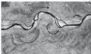
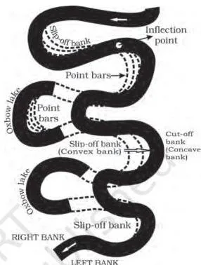
Figure 6.6, a satellite scene of the Burhi Gandak near Muzaffarpur, shows the result of repeated cut-offs: a number of oxbow lakes. Figure 6.7 traces meander growth, naming the slip-off and undercut banks. As loops grow deeper, erosion at the inflection points cuts them off, leaving the abandoned loop as an oxbow lake (p. 51).
Groundwater and Karst Topography
Groundwater’s physical or mechanical removal of material is insignificant in developing landforms. Its results appear only where rocks can be dissolved – limestones and dolomites rich in calcium carbonate – through the chemical processes of solution and precipitation (p. 52).
Regions that show these landforms are said to have karst topography, named after the Karst region in the Balkans, adjacent to the Adriatic Sea (p. 52).
Erosional Karst Forms
- Swallow holes – small to medium sized shallow depressions formed on limestone surfaces through solution (p. 52).
- Sinkholes – openings circular at the top and funnel-shaped toward the bottom, ranging from a few square metres to a hectare in area and from under half a metre to thirty metres or more in depth. Purely solution-made forms are solution sinks; forms that collapse when the sinkhole bottom was the roof of a cave are collapse sinks, sometimes called dolines (pp. 52-53). Soil-covered sinkholes look like shallow pools and behave like desert quicksands (p. 53).
- Uvalas (valley sinks) – long, narrow to wide trenches formed when sinkholes and dolines join through slumping of margins or roof collapse of caves (p. 53).
- Lapies – an irregular surface of pinnacles, grooves and ridges formed by differential solution along parallel or sub-parallel joints; a lapie field may grade into a smooth limestone pavement (p. 53).
- Caves – long, narrow to wide gaps formed along bedding planes where limestones alternate with shales, sandstones or quartzites, or where limestone is dense and massive. Caves open at both ends are called tunnels (p. 53).
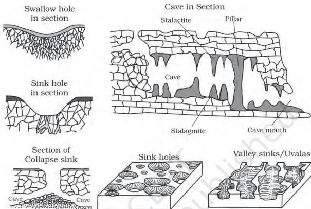
Figure 6.8 gathers the karst features in one diagram. Surface swallow holes and sinkholes, the larger uvalas where they have coalesced, and the cave system beneath the limestone surface all belong to the same solution-based story (pp. 52-53).
Depositional Forms Inside Caves
The chief chemical in limestone is calcium carbonate, which dissolves readily in carbonated water and is redeposited when the carrying water evaporates or loses carbon dioxide (p. 53).
- Stalactites hang from cave roofs like icicles – broad at their bases, tapering toward the free end.
- Stalagmites rise from the cave floor, formed by water dripping from the cave surface or through the pipe of a stalactite immediately above.
- When stalagmites and stalactites eventually fuse, they give rise to columns and pillars of different diameters (pp. 53-54).
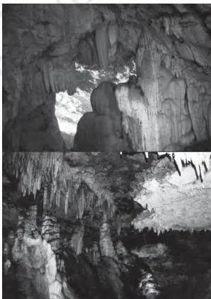
Figure 6.9 shows both forms in a limestone cave. Memory device: stalactite has a c for ceiling and holds tight to it; stalagmite has a g for ground and grows up from it.
Glaciers: Landforms of Ice
Glaciers are masses of ice moving as sheets over land (continental glaciers; a piedmont glacier when a vast sheet spreads over plains at the foot of mountains) or as linear flows down mountain slopes in trough-like valleys (mountain or valley glaciers) (p. 54). Movement is slow – a few centimetres to a few metres a day – and is driven by gravity (p. 54).
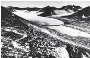
Glacial erosion is tremendous because of the sheer weight of ice. Plucking drags large angular blocks along the floors and sides of valleys; abrasion grinds even unweathered rock. Together they can reduce high mountains to low hills and plains (p. 54). Figure 6.10 shows a glacier in its valley – the moving ice whose weight drives both processes.
The chapter gives an Indian application: the snout (Gaumukh) of the Gangotri glacier feeds the Bhagirathi, and the Alkapuri glacier feeds the Alaknanda; the two rivers join near Devprayag to form the Ganga (p. 54).
Erosional Glacial Landforms
- Cirques – deep, long and wide basins with very steep concave to vertical walls at their heads and sides, the most common landforms in glaciated mountains. After the ice disappears they often hold a cirque or tarn lake, and cirques may occur in stepped sequences (p. 54).
- Horns – sharp, pointed, steep-sided peaks formed when three or more radiating glaciers cut headward until their cirques meet. The Matterhorn in the Alps and Everest are examples (p. 54).
- Arêtes – serrated, saw-toothed ridges formed as the divides between cirque walls are progressively narrowed (p. 54).
- Glacial valleys or troughs – U-shaped, with broad floors and steep smooth sides. Hanging valleys and truncated spurs open into the main valley; very deep glacial troughs filled with sea water at high-latitude shorelines are called fjords (p. 55).
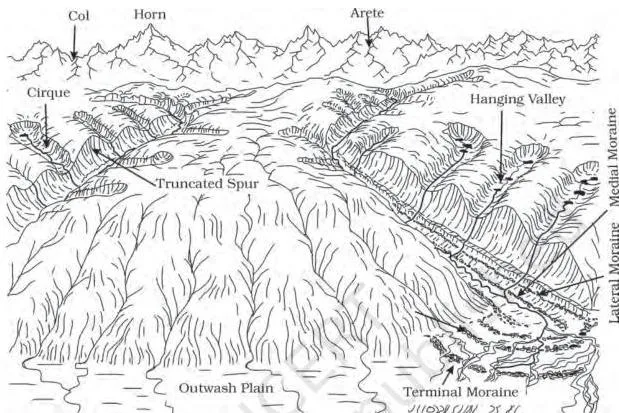
Figure 6.11 brings several glacial forms together in one labelled diagram. Use it to attach names – cirque, arête, horn, moraines – to the shapes described in the text (p. 55).
Depositional Glacial Landforms
- Glacial till – unassorted coarse and fine debris dropped directly by melting ice; fragments are angular to sub-angular (p. 55).
- Outwash deposits – debris carried and deposited by meltwater streams; roughly stratified and assorted, with somewhat rounded fragments (p. 55).
- Eskers – sinuous ridges of coarse material laid down by streams that flowed in channels beneath the ice (p. 56).
- Outwash plains – broad, flat glacio-fluvial fans of gravel, silt, sand and clay beyond the glacier foot (p. 56).
- Drumlins – smooth, oval ridges of till with some gravel and sand, up to about 1 km long and 30 m high, with long axes parallel to the direction of ice movement. The stoss end, facing the glacier, is blunter and steeper; the tail is gentler. Drumlins therefore record the direction of ice movement (pp. 56-57).
| Moraine type | Position | Key feature |
|---|---|---|
| Terminal | At the toe or end of the glacier | Long ridge of debris deposited at the terminus |
| Lateral | Along the sides, parallel to the valley | May join the terminal moraine into a horse-shoe shaped ridge |
| Ground | Over the valley floor | Irregular sheet of till left by rapidly retreating glaciers |
| Medial | In the centre of the valley, flanked by lateral moraines | Imperfectly formed; may be indistinguishable from ground moraine |
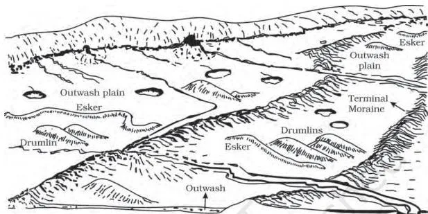
Figure 6.12, a panoramic glacial landscape, shows the depositional forms spread across the scene described in the text – outwash spread, moraines and the rest (p. 56).
Waves and Currents: Coastal Landforms
Coastal processes are the most dynamic and hence most destructive of the geomorphic agents. Changes can happen in a single season – erosion at one time, deposition in another – and storm waves and tsunami waves reshape coasts far faster than normal breakers (p. 57). Assuming sea level is constant, the chapter explains coastal evolution through two coast types (p. 57).
| Feature | High rocky (submerged) coast | Low sedimentary (emerged) coast |
|---|---|---|
| Rivers | Appear drowned; coastline highly indented | Extend their length by building coastal plains and deltas |
| Slope | Hill sides drop off sharply into the water | Land slopes gently into the water |
| Initial shore | No depositional forms; erosion features dominate | Smooth coastline with lagoons and tidal creeks; deposition dominates |
| Typical landforms | Cliffs, wave-cut platforms, sea caves, sea stacks | Beaches, dunes, bars, spits, lagoons, deltas |
High Rocky Coasts
- Waves break against hillsides and shape them into cliffs (p. 57).
- As cliffs recede, they leave a wave-cut platform in front of the sea cliff. Later, rock debris deposited offshore builds a wave-built terrace in front of it (p. 57).
- Lashing waves and smashed rock debris carve hollows at the cliff base; these widen into sea caves. When cave roofs collapse, the cliff retreats further and isolated resistant remnants are left as sea stacks (p. 58).
Low Sedimentary Coasts
- Churned bottom sediments build bars – long submerged ridges of sand or shingle parallel to the coast. Bars exposed above water are barrier bars; barrier bars keyed up to a headland or bay end are spits; bars and spits blocking a bay mouth form a lagoon (pp. 57-59).
- Lagoons fill with sediment from the land to become coastal plains (p. 59).
- Beaches are temporary, mostly sand-sized deposits; shingle beaches contain pebbles and even cobbles. Winds lift sands from the beach and deposit them as sand dunes in ridges parallel to the coast (p. 58).
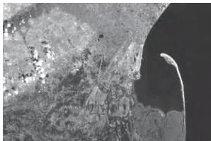
Figure 6.13, part of the Godavari delta, is the chapter’s example of a spit extending along the coast (p. 59).
A practical note closes the section: offshore bars are the first buffer that absorbs storm or tsunami force; then barriers, beaches, beach dunes and mangroves absorb the rest. Anything that disturbs the sediment budget or the mangroves removes this defence and exposes coastal habitations to the first strike (p. 59).
India shows both coast types clearly: the west coast is a high rocky retreating coast where erosional forms dominate, while the east coast is a low sedimentary coast where depositional forms dominate (p. 58).
Wind: Landforms of Hot Deserts
Correct a likely misconception first: wind is one of the two dominant agents in hot deserts, but many desert features owe their origin to mass wasting and running water acting as sheet floods. Torrential desert rain removes weathered debris that wind alone cannot move (p. 59).
Wind erodes in three ways (p. 59):
- Deflation – lifting and removal of dust and smaller particles from the rock surface.
- Abrasion – sand and silt acting as tools that grind the land surface.
- Impact – the sheer force of momentum when sand is blown against a rock surface, similar to sand-blasting.
Erosional Desert Landforms
- Pediments – gently inclined rocky floors at the foot of mountains, formed by lateral stream erosion combined with sheet flooding (pp. 59-60).
- Parallel retreat of slopes through backwasting lets pediments extend backward at the expense of the mountain front, leaving a remnant called an inselberg; continued retreat reduces high relief to low, featureless pediplains (p. 60).
- Playa lakes – shallow lakes in basin centres that hold water only briefly and leave salt deposits; a salt-covered playa plain is an alkali flat (p. 60).
- Deflation hollows – shallow depressions created by persistent winds blowing in one direction (p. 60).
- Blow outs – shallow depressions first created by impact and abrasion of wind-borne sand; some deepen and widen until they are fit to be called caves (p. 60).
- Mushroom, table and pedestal rocks – resistant remnants left standing when weaker surrounding rock is worn away by deflation and abrasion (p. 60).
Depositional Desert Landforms: Sand Dunes
Wind is a good sorting agent. Grains move by rolling, saltation and suspension, and settle as wind velocity drops, so dune deposits are well sorted (p. 60). Dune shapes depend on wind constancy, sand supply, the original surface, and vegetation cover (pp. 60-61).
| Dune type | Shape | Condition of formation |
|---|---|---|
| Barchan | Crescent-shaped; wings or points directed downwind | Constant and moderate wind over a uniform surface |
| Parabolic | Reversed barchan – same wind direction, opposite curvature | Sandy surface partially covered with vegetation |
| Seif | Barchan-like with only one wing; can grow very long and high | A shift in wind conditions |
| Longitudinal | Long low ridges aligned with the wind | Poor sand supply with constant wind direction |
| Transverse | Long low ridges aligned perpendicular to the wind | Elongated sand source at right angles to the wind |
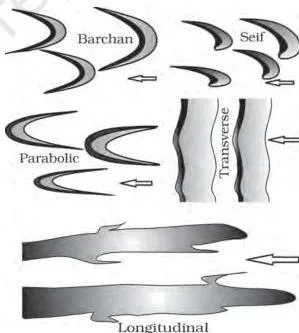
Figure 6.14 shows the dune types with arrows indicating wind direction. Note the reversal: a barchan’s wings trail downwind, while a parabolic dune curves the opposite way under the same wind because vegetation anchors its wings (p. 61).
Landform Glossary: Terms and Meanings
Use this table as a quick reference. Definitions are deliberately one or two lines so you can revise the whole chapter’s vocabulary in one pass.
| Term | Meaning | Example / Indian location |
|---|---|---|
| Landform | Small to medium sized tract or parcel of the earth’s surface | A gorge, a delta |
| Landscape | Several related landforms together, forming a large tract | The landforms of a whole river basin |
| Peneplain | An almost plain produced by long stream erosion | End product of the old stage |
| Monadnock | Low resistant remnant standing above a peneplain | Occasional isolated hills |
| Gorge | Deep valley with very steep to straight sides, almost equal width at top and bottom | Kaveri valley near Hogenekal (p. 49) |
| Canyon | Variant of gorge; steep step-like side slopes, wider at top than bottom | Colorado entrenched meander (p. 49) |
| Pothole | Circular depression on a rocky stream bed, enlarged by rotating pebbles and boulders | Rocky beds of hill-streams (pp. 48-49) |
| Plunge pool | Large, deep pothole at the foot of a waterfall | Base of waterfalls (p. 49) |
| Incised (entrenched) meander | Deep, wide meander cut into hard rock | Colorado river loop (p. 49) |
| River terrace | Surface marking an old valley floor or floodplain level; paired when equal on both sides | Old river levels (p. 49) |
| Alluvial fan | Cone-shaped deposit where a mountain stream breaks onto a low-gradient foot slope | Amarnath hill-stream fan (p. 50) |
| Delta | Fan built where river load spreads into the sea; well sorted, clearly stratified | Krishna delta (p. 50) |
| Floodplain | Major landform of river deposition; river-bed part active, above-bank part inactive | Delta plains (p. 50) |
| Natural levee | Low, linear, parallel ridge of coarse deposits along a large river’s bank | Banks of large rivers (p. 51) |
| Point bar (meander bar) | Almost uniform linear deposit of mixed sediments along a meander bank | Meanders of large rivers (pp. 50-51) |
| Oxbow lake | Cut-off meander loop left beside a river after erosion at inflection points | Burhi Gandak near Muzaffarpur (p. 51) |
| Karst topography | Limestone/dolomite landscape formed by solution and precipitation | Karst region in the Balkans (p. 52) |
| Sinkhole | Opening, circular at top and funnel-shaped toward bottom; solution sink or collapse sink (doline) | Karst areas (pp. 52-53) |
| Uvala (valley sink) | Long, narrow to wide trench formed as sinkholes and dolines join | Karst terrain (p. 53) |
| Lapies | Irregular surface of pinnacles, grooves and ridges from differential solution | Jointed limestone fields (p. 53) |
| Stalactite | Icicle-like deposit hanging from a cave roof | Limestone caves (p. 53) |
| Stalagmite | Deposit rising from a cave floor below a stalactite | Limestone caves (pp. 53-54) |
| Cirque | Deep, long, wide basin with steep concave walls at a glacial valley head; may hold a tarn lake | Heads of glaciated valleys (p. 54) |
| Horn | Sharp, steep-sided peak formed where radiating cirques meet | Matterhorn, Everest (p. 54) |
| Arête | Serrated saw-tooth ridge between cirque walls | Alpine divides (p. 54) |
| Glacial trough | U-shaped valley with broad floor and steep sides; sea-filled form is a fjord | High-latitude shores (p. 55) |
| Glacial till | Unassorted angular debris dropped by melting ice | Glacier floors (p. 55) |
| Moraine | Long ridge of till – terminal, lateral, ground or medial | Along and at the end of glaciers (pp. 55-56) |
| Esker | Sinuous ridge of coarse material deposited by under-ice meltwater streams | Beds of former glaciers (p. 56) |
| Drumlin | Smooth oval ridge of till; stoss end blunt and facing the glacier | Up to 1 km long, 30 m high (pp. 56-57) |
| Wave-cut platform | Flat or gently sloping rock platform left as a sea cliff retreats | Rocky coasts (p. 57) |
| Sea stack | Isolated resistant rock remnant left offshore after cliff retreat | Rocky coasts (p. 58) |
| Barrier bar | Offshore bar that shows above water | Parallel to the coast (p. 58) |
| Spit | Barrier bar keyed up to a headland or bay end | Godavari delta (p. 59) |
| Lagoon | Bay mouth blocked by bars and spits; may fill to become a coastal plain | Low sedimentary coasts (p. 59) |
| Pediment | Gently inclined rocky floor at the foot of a mountain | Desert mountain fronts (pp. 59-60) |
| Inselberg | Remnant of a mountain left as pediments extend backward | Desert plains (p. 60) |
| Playa | Shallow desert lake that holds water briefly; salt-covered form is an alkali flat | Desert basin centres (p. 60) |
| Barchan | Crescent dune with wings pointing downwind | Constant moderate desert winds (p. 61) |
| Seif | Barchan-like dune with only one wing, growing long and high | Shifted wind conditions (p. 61) |
Process Sequences: The Chapter’s ‘Formulas’
This chapter has no equations, but it does have process formulas – the fixed cause-to-effect chains by which one feature turns into the next. Learn these chains and 30-word answers write themselves.
| Process chain | What it explains |
|---|---|
| Overland flow → rills → gullies → valleys | How a stream valley begins from sheet flow (p. 48) |
| Youth (down-cutting, waterfalls removed) → mature (lateral erosion dominates) → old (deposition and meandering) → peneplain with monadnocks | The whole life cycle of stream-eroded relief (p. 48) |
| Solution in limestone → swallow holes → sinkholes → uvalas → lapies → limestone pavements | Progressive karst surface roughening, then smoothing (pp. 52-53) |
| Cave-roof drips → stalactites and stalagmites → fused columns and pillars | Cave interior decoration by precipitation (pp. 53-54) |
| Meander loop deepens (deposition inside, undercutting outside) → cut-off at inflection points → oxbow lake | How meanders abandon loops (p. 51) |
| Radiating cirques cut headward → horns and arêtes | Peaks and ridges between glacial valleys (p. 54) |
| Cliff erosion by waves → wave-cut platform → wave-built terrace | Two-stage evolution of a rocky shore (p. 57) |
| Deflation and abrasion → hollows → blow outs → caves | Wind-carved cavities (p. 60) |
| Mountain front backwasting → pediment extension → inselberg → pediplain | Desert relief reduction (p. 60) |
Worked Identification: Name That Landform
Identify any landform with four checks: agent, process, erosional or depositional, and diagnostic shape. The four examples below run that method in numbered steps with original descriptions.
Example 1: The Deep Basin With a Lake
Description: A trekker in the Himalayas reports a deep basin with near-vertical concave walls, carved into the head of a mountain valley and holding a small lake.
- Agent: steep concave walls are a glacial signature – rivers cut V-shaped valleys, not basins with vertical walls.
- Position: the basin sits at the head of a valley, where accumulated ice cuts while moving down from mountain tops (p. 54).
- The lake: after the ice disappears, such basins often hold a cirque or tarn lake (p. 54).
Answer: cirque with a tarn lake. Diagnostic line: deep basin + steep concave walls + valley head + a lake.
Example 2: The Crescent Lake After a Flood
Description: After a flood, a farmer finds a crescent-shaped lake beside the river; the river now flows along a shorter course nearby.
- Shape: the looped channel on a floodplain is a meander – a channel pattern, not a landform (p. 51).
- Shortcut: a shortened course means the loop was cut off by erosion at the inflection points (p. 51).
- The abandoned loop now holds still water as an oxbow lake (p. 51).
Answer: oxbow lake. Diagnostic line: crescent lake beside a river on a floodplain + shortened river course.
Example 3: The Mushroom Rock in a Desert
Description: A traveller in a stony desert sees a rock shaped like a mushroom – a broad rounded cap on a slender stalk.
- Setting: in a desert, wind is a dominant agent and a likely sculptor (p. 59).
- Shape: a broad cap with a narrowed base matches wind abrasion, which is strongest near the ground, plus deflation of fine material from the base (p. 60).
- Resistance: the hard cap survived while weaker rock around the base wore away.
Answer: mushroom rock (table and pedestal rocks are variants of the same remnant). Diagnostic line: desert setting + broad cap + slender stalk.
Example 4: A Limestone Depression With a Sinking Stream
Description: A surveyor records a limestone depression 12 m deep with a surface opening of roughly 80 square metres and a stream sinking into it. Nearby, another opening exposes a hollow cave roof.
- Rock type: limestone + a disappearing stream point to chemical solution by groundwater (p. 52).
- Shape: an opening circular at the top and funnel-shaped toward the bottom is a sinkhole (pp. 52-53).
- Process check: if the depression formed purely by solution, it is a solution sink. If it exposes a cave roof, the bottom collapsed into a void below, so it is a collapse sink or doline (p. 53).
Answer: the first is a solution sink; the second is a collapse sink (doline). Diagnostic line: funnel-shaped opening in limestone + exposed cave roof = collapse sink.
Common Mistakes in Landform Identification and Naming
| Students write | Correct is | How to check your answer |
|---|---|---|
| A meander is a landform | Meander is a channel pattern – the looped course of a river – not a landform (p. 51) | Recall that a landform is a physical tract; a meander is the shape of the channel on it |
| A gorge and a canyon are the same | Canyon is a variant of gorge: gorge has very steep or straight sides with nearly equal top and bottom widths; canyon has step-like slopes and is wider at the top (p. 48) | Ask which rock fits: gorges in hard rocks, canyons in horizontal bedded sedimentary rocks |
| Stalactites grow up from the floor | Stalactites hang from the ceiling (c for ceiling); stalagmites rise from the ground (g for ground) below a stalactite (pp. 53-54) | Picture the drip: the ceiling builds downward, the floor builds upward |
| Deposition happens on the outside of a meander bend | Deposition is on the convex (inside) slip-off bank; undercutting is on the concave (outside) cut-off bank with a steep scarp (p. 51) | Draw a loop: the gently sloping bank receives sediment, the steep scarp loses it |
| Till and outwash are the same glacial debris | Till is unassorted angular debris dropped by melting ice; outwash is roughly stratified, assorted and rounded, laid by meltwater streams (p. 55) | Check sorting and roundness: sorted and rounded means outwash |
| Barchan wings point into the wind | Barchan wings point downwind; a parabolic dune is a reversed barchan under the same wind (p. 61) | Follow the arrows in Figure 6.14 |
| The drumlin’s stoss end points where the ice went | The blunt stoss end faces the glacier – where the ice came from; the tail points in the direction of movement (pp. 56-57) | Remember: stoss is the pushed, blunted side |
| Wind alone builds all desert landforms | Wind is one of two dominant desert agents; mass wasting and running water as sheet floods also shape deserts (p. 59) | Match each desert form to its process before blaming the wind |
One wording trap sits inside the textbook itself. The point-bar sentence places point bars on the concave side of meanders (p. 50), but the meander description says deposition is active along the convex bank (p. 51).
For an answer that quotes NCERT, reproduce the textbook’s own sentence; for understanding the process, follow the meander figure – deposition builds the inside of the bend, so point bars are products of the convex bank.
Exam Notes: Answering This Chapter’s Questions
The Chapter’s In-Text Check Questions
The chapter breaks its sections with ‘?’ prompts. Treat them as a self-test: cover the section, answer out loud, then check. Paraphrased, they are:
| Check question (paraphrased) | Page | Concept it tests |
|---|---|---|
| What are the two important aspects of landform evolution? | 47 | Erosion followed by deposition, plus the youth-mature-old stage idea |
| Can a high land mass be completely reduced of its relief? | 48 | Peneplain formation and resistant monadnocks |
| How do natural levees differ from point bars? | 51 | Bank-side coarse ridges vs mixed-size linear deposits at meanders |
| What are the basic differences between glacial valleys and river valleys? | 55 | U-shaped troughs vs V-shaped winding river valleys |
| Distinguish river alluvial plains from glacial outwash plains. | 56 | River-sorted deposits vs roughly stratified glacio-fluvial deposits |
| What is the difference between till and alluvium? | 57 | Unassorted angular till vs water-sorted rounded alluvium |
| Differences between high rocky and low sedimentary coasts in processes and landforms? | 58 | Erosion-dominated vs deposition-dominated coasts |
| List the erosional features carved by wind action and sheet floods. | 60 | Deflation hollows, blow outs, caves, plus sheet-flood forms |
The End-of-Chapter Exercise Map
The chapter’s exercises on pp. 61-62 are printed in the textbook; this page deliberately does not reproduce their answers. What matters for revision is knowing what each item demands.
- Five multiple choice questions – each tests an exact definition: the youth stage as the stage of downward cutting; canyon as the valley with steep step-like side slopes; humid regions as where chemical weathering dominates over mechanical; lapies as the irregular surface with sharp pinnacles, grooves and ridges; cirque as the deep, long, wide basin with steep concave walls.
- Five short questions (about 30 words) – they span incised vs plain meanders and what they indicate, the evolution of uvalas, why underground flow beats surface run-off in limestone areas, the locations and names of linear glacial deposits, and whether wind alone makes desert erosional features.
- Three long questions (about 150 words) – running water as the dominant geomorphic agent in both humid and arid climates; limestone behaviour in humid vs arid climates plus the dominant process in limestone areas and its results; and how glaciers reduce high mountains to low hills and plains.
- Project work – identify the landforms, materials and processes around your area by field observation.
The Five Distinguish Pairs
Several exercise tasks ask you to distinguish two landforms or deposits. Learn one or two diagnostic criteria per pair.
| Pair | Diagnostic criteria |
|---|---|
| Glacial valley vs river valley | Glacial: U-shaped, broad straight floor, steep sides, hanging valleys and truncated spurs. River: V-shaped and winding, with floodplains along gentle reaches (pp. 55, 48) |
| Natural levee vs point bar | Levee: low, linear, parallel ridges of coarse deposits along river banks. Point bar: almost uniform, mixed-size linear deposits along the inside of meanders (pp. 50-51) |
| River alluvial plains vs glacial outwash plains | Alluvial: river-borne deposits along a river system, well sorted. Outwash: roughly stratified glacio-fluvial deposits in broad flats beyond the glacier foot (pp. 50, 56) |
| Till vs alluvium | Till: unassorted fragments, angular to sub-angular, dropped by melting ice. Alluvium: sediment sorted and rounded by running water (pp. 55, 57) |
| High rocky vs low sedimentary coasts | High rocky: submerged, indented, drowned rivers and fjords; erosion dominates with cliffs, wave-cut platforms and stacks. Low sedimentary: emerged, smooth, gently sloping; deltas, lagoons, bars and spits; deposition dominates (pp. 57-58) |
Structure for a ~30-word answer: open with the term or definition, add one process step, close with one example. Structure for a ~150-word answer: open with a defining statement, run the cause-to-effect chain in order, list the landforms produced, and close with a chapter Indian example – Kaveri gorge, Krishna delta, Burhi Gandak oxbows, Gangotri-Bhagirathi, or the Godavari spit.
One-Page Revision Recap
1. Agents and Their Landforms – Tightest Form
| Agent | Erosional landforms | Depositional landforms |
|---|---|---|
| Running water | V-shaped valleys, gorges, canyons, potholes, incised meanders | Fans, deltas, floodplains, levees, point bars, oxbow lakes |
| Groundwater | Swallow holes, sinkholes, uvalas, lapies, caves | Stalactites, stalagmites, columns and pillars |
| Glaciers | Cirques, horns, arêtes, U-shaped troughs, fjords | Till, moraines, eskers, outwash plains, drumlins |
| Waves and currents | Cliffs, wave-cut platforms, sea caves, sea stacks | Terraces, beaches, bars, spits, lagoons, dunes |
| Wind | Pediments, inselbergs, pediplains, hollows, mushroom rocks | Playa flats and dunes of all types |
2. River Stages in a Nutshell
| Feature | Youth | Mature | Old |
|---|---|---|---|
| Streams | Few, poorly integrated | Plenty, well integrated | Few gentle tributaries |
| Valleys | Shallow V-shaped | Deep V-shaped | Free meandering over vast floodplains |
| Floodplains and divides | Narrow floodplains, broad wet divides | Wider floodplains, sharp divides | Vast floodplains, broad flat divides |
| Waterfalls | Present at hard rock | Disappear | Absent |
3. Indian Examples From the Chapter
| Location | Landform it shows |
|---|---|
| Kaveri near Hogenekal | Gorge (p. 49) |
| Colorado entrenched meander | Canyon (p. 49) |
| Hill stream on the way to Amarnath | Alluvial fan (p. 50) |
| Krishna river | Delta (p. 50) |
| Burhi Gandak near Muzaffarpur | Meanders with oxbow lakes and cut-offs (p. 51) |
| Gangotri (Gaumukh) and Alkapuri glaciers | Feed the Bhagirathi and Alaknanda; the rivers join at Devprayag to form the Ganga (p. 54) |
| Godavari delta | Spit (p. 59) |
| West and east coasts of India | High rocky retreating coast vs low sedimentary coast (p. 58) |
4. Five One-Line Memory Hooks
- Meander is a pattern, not a landform.
- Stalactite: c for ceiling; stalagmite: g for ground.
- Barchan wings point downwind.
- The drumlin’s stoss end faces the glacier.
- Karst means limestone.
You are now ready to move through the rest of the Class 11 Geography notes – the section also carries chapters like Composition and Structure of Atmosphere. For other subjects, browse other Class 11 notes, and return to the CBSE notes library whenever you need to revise another chapter.
Frequently Asked Questions
Is a meander a landform?
No. NCERT explicitly says a meander is not a landform but only a type of channel pattern – the looped course of a river on flood and delta plains (p. 51). It does, however, produce landforms such as oxbow lakes when loops are cut off.
How do I tell a gorge from a canyon?
A gorge has very steep to straight sides and is almost equal in width at the top and bottom; it forms in hard rocks. A canyon has steep step-like side slopes and is wider at the top than the bottom; it is a variant of the gorge, common in horizontal bedded sedimentary rocks (p. 48).
Why do stalactites hang from cave ceilings while stalagmites rise from the floor?
Calcium carbonate is deposited as dripping water evaporates or loses carbon dioxide. Drips on the ceiling build downward as stalactites, while drips landing on the floor build upward as stalagmites; when they fuse they form columns and pillars (pp. 53-54).
Why are barchan and parabolic dunes reversed if the wind direction is the same?
A barchan forms over a bare, uniform surface with its wings pointing downwind. A parabolic dune forms where vegetation partly covers the sand and anchors the wings, so the curvature is reversed while the wind direction stays the same (p. 61).
Why does karst topography appear only in limestone and dolomite regions?
Groundwater’s physical or mechanical erosion is insignificant. Karst landforms depend on chemical solution and precipitation, which need rocks rich in calcium carbonate such as limestone and dolomite (p. 52).
Which Indian coast is erosional and which is depositional?
The west coast is a high rocky retreating coast, so erosional forms dominate. The east coast is a low sedimentary coast, so depositional forms dominate (p. 58).
Reference: NCERT Class 11 Geography textbook, chapter 6, Landforms and Their Evolution.
Explore Class 11 Geography Notes
- Class 11 Geography Notes
- Class 11 CBSE Notes
- CBSE Notes for Classes 9 to 12
- Next: Composition and Structure of Atmosphere
Class 11 Geography on LearnCBSE:
Related chapters:
- Water in the Atmosphere notes
- Water (oceans) notes
Official source: download the NCERT textbook free from ncert.nic.in.