These resources and development class 10 notes cover the entire chapter for the current academic session. Use them for quick CBSE board revision — the definitions, tables, and exam pointers are written so a student can revise the night before a test. For more Geography chapters, visit our Class 10 Geography notes hub.
The chapter in brief: a resource is something from the environment we can actually use to meet our needs, given the right technology and economic feasibility; this lesson explains how India classifies, plans, degrades and conserves its land and soil wealth. You can also browse all our CBSE revision notes or return to the main Class 10 notes index.
What Makes a Resource: Origin, Exhaustibility, Ownership, Status
Everything available in our environment that can be used to satisfy our needs is a resource — but only when it is technologically accessible, economically feasible, and culturally acceptable (NCERT, p. 1). The resource is not a free gift of nature; human beings turn material into a resource using technology and institutions.
A memory device for the three conditions — T-E-C triad: Technologically accessible, Economically feasible, Culturally acceptable. If any one of these three fails, the material stays a mere thing, not a resource.
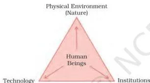
The diagram above shows the nature-technology-institutions triangle. Human beings interact with nature through technology and create institutions to accelerate economic development. Together they transform raw material into a usable resource.
Resources can be classified on four different bases. The table below gives one example per cell so you can revise quickly.
| Basis | Categories | Example |
|---|---|---|
| Origin | Biotic / Abiotic | Plants and animals (biotic); rocks and minerals (abiotic) |
| Exhaustibility | Renewable / Non-renewable | Solar and wind energy (renewable); coal and petroleum (non-renewable) |
| Ownership | Individual / Community / National / International | Private farmland (individual); village grazing land (community); government forest (national); oceanic waters beyond 200 nautical miles (international) |
| Status of development | Potential / Developed stock / Reserves | Wind power in a remote valley not yet tapped (potential); working iron-ore mine (developed stock); known coal seam not yet extracted but economically viable (reserves) |
The origin split is biotic vs abiotic — living vs non-living. The exhaustibility split concerns whether a resource can regenerate in human time-scales; non-renewable resources exist in a fixed stock, so once mined they are gone. Ownership categories tell us who controls the resource: an individual, a village community, the nation, or the global community.
The fourth basis is the one students mix up most often. Potential resources exist in a region but have not been put to use yet because technology or economic viability is lacking. Developed stock refers to resources that are already being surveyed, quantified and used.
Reserves are the usable part of the developed stock that can be extracted profitably with current technology.
Why Resource Planning Matters in India
India has enormous diversity in the availability of resources. Some regions are rich in one type of resource and deficient in another, so planning is essential for balanced development (NCERT, p. 2-3). The state-wise imbalance examples from the textbook show this clearly:
- Jharkhand, Chhattisgarh, Madhya Pradesh — rich in minerals and coal deposits, but need development in other sectors.
- Arunachal Pradesh — abundance of water resources but lacks infrastructural development.
- Rajasthan — well endowed with solar and wind energy but lacks in water resources.
- Ladakh cold desert — isolated from the rest of the country, deficient in water, infrastructure and some vital minerals, yet has a rich cultural heritage.

Balanced resource planning has to happen at the national, state, regional and local levels so that a resource rich region can support a resource poor one.
Resource planning is a three-step process (NCERT, p. 3):
- Identification and inventory — surveying, mapping and qualitative and quantitative estimation and measurement of resources across the regions of the country.
- Planning structure — evolving a structure with appropriate technology, skill and institutional set up for implementing resource development plans.
- Matching plans — matching the resource development plans with overall national development plans.
India has made concerted efforts for resource planning right from the First Five Year Plan launched after Independence. But availability of resources alone does not bring development. Regions can be rich in resources yet economically backward, or resource-poor yet economically developed — because development also requires technology, quality of human resources and historical experiences.
Sustainable Development, Rio Summit and Agenda 21
Sustainable development means development should take place without damaging the environment, and development in the present should not compromise the needs of future generations (NCERT, p. 2).
Sustainable development (definition): Development that meets present needs without damaging the environment or reducing the ability of future generations to meet their own needs.
Indiscriminate exploitation of resources has led to problems like depletion of resources for satisfying the greed of a few, accumulation of resources in a few hands creating haves and have-nots, and global ecological crises such as global warming, ozone layer depletion, environmental pollution and land degradation.
An international timeline of key conservation milestones helps answer two- and three-mark questions:
| Year | Milestone | Significance |
|---|---|---|
| 1968 | Club of Rome | Advocated resource conservation for the first time in a systematic way |
| 1974 | Schumacher, Small is Beautiful | Presented Gandhian philosophy again; argued against mass production |
| 1987 | Brundtland Commission Report | Introduced the term ‘Sustainable Development’; published as Our Common Future |
| 1992 | Rio de Janeiro Earth Summit | Signed the Declaration on Global Climatic Change and Biological Diversity; adopted Agenda 21 and endorsed global Forest Principles |
Agenda 21 is the declaration signed at the 1992 UNCED (United Nations Conference on Environment and Development) in Rio. It aims at achieving global sustainable development by combating environmental damage, poverty and disease through global co-operation. One major objective is that every local government should draw its own local Agenda 21 (NCERT, p. 2).
Gandhiji’s quote: “There is enough for everybody’s need and not for any body’s greed.” He placed greedy individuals and exploitative modern technology as the root cause of resource depletion.
Land Resources and Land Utilisation Categories
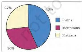
Land is a natural resource of utmost importance — it supports natural vegetation, wildlife, human life, transport and communication systems. But land is a finite asset, so careful planning matters. India’s relief features break down as follows (NCERT, p. 4):
- 43% plains — provide facilities for agriculture and industry
- 30% mountains — ensure perennial flow of rivers, provide tourism and ecological aspects
- 27% plateaus — rich reserves of minerals, fossil fuels and forests
The five land utilisation categories students must distinguish are given below in a nested list (NCERT, p. 4):
- 1. Forests
- 2. Land not available for cultivation
- Barren and waste land
- Land put to non-agricultural uses (buildings, roads, factories)
- 3. Other uncultivated land (excluding fallow land)
- Permanent pastures and grazing land
- Land under miscellaneous tree crops and groves (not included in net sown area)
- Culturable waste land (left uncultivated for more than 5 agricultural years)
- 4. Fallow lands
- Current fallow (left without cultivation for one or less than one agricultural year)
- Other than current fallow (left uncultivated for the past 1 to 5 agricultural years)
- 5. Net sown area
- Physical extent of land on which crops are sown and harvested
- Gross cropped area = area sown more than once in an agricultural year plus net sown area
Net sown area (NSA) is the physical extent of land on which crops are sown and harvested in a given agricultural year. Gross cropped area (GCA) counts every time a piece of land is sown; if a plot is sown twice in the same year, it adds twice in the GCA but once in the NSA.
India’s Land Use Pattern: Why Forest Cover Stays Below 33%
Land use is determined by physical factors (topography, climate, soil types) as well as human factors (population density, technological capability, culture and traditions) (NCERT, p. 4). The pie chart below shows the 2026-27 break-up of land use categories for the reporting area (100 percent).
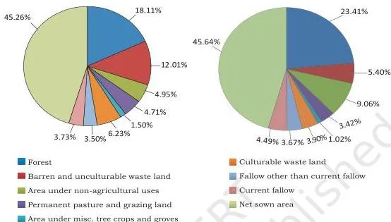
Land use data is available only for 93 per cent of the total geographical area (3.28 million sq km) because the north-east states (except Assam) have not been fully surveyed, and parts of Jammu and Kashmir occupied by Pakistan and China have also not been surveyed (NCERT, p. 5).
Two trends deserve attention:
- The net sown area and the land under forests have changed only marginally from 1960-61 to 2026-27.
- The land under permanent pasture has decreased, and most of the other-than-current fallow lands are of poor quality or high cost of cultivation.
State variation in net sown area is wide: it is over 80 per cent of the total area in Punjab and Haryana, and less than 10 per cent in Arunachal Pradesh, Mizoram, Manipur and Andaman and Nicobar Islands (NCERT, p. 5).
Forest area is far lower than the 33 per cent desired in the National Forest Policy (1952) — essential for maintaining ecological balance. The livelihood of millions living on forest fringes depends on it.
Land Degradation Causes and Conservation
Land degradation results from continuous use of land without conservation measures. Human activities like deforestation, overgrazing, mining and quarrying, and over-irrigation aggravate the pace of natural forces of damage (NCERT, p. 6). The state-cause mapping below is a comparison table that competitors scatter across paragraphs.
| State(s) / zone | Main cause of land degradation | Effect |
|---|---|---|
| Jharkhand, Chhattisgarh, Madhya Pradesh, Odisha | Deforestation due to mining | Deep scars and traces of over-burdening after excavation ends |
| Gujarat, Rajasthan, Madhya Pradesh, Maharashtra | Overgrazing | Vegetation cover lost; soil exposed to erosion |
| Punjab, Haryana, western Uttar Pradesh | Over-irrigation | Water logging leads to salinity and alkalinity in the soil |
| Cement and ceramic industry zones (grinding limestone, calcite, soapstone) | Huge dust in the atmosphere settling on land | Retards infiltration of water into the soil after it settles down |
Conservation measures to reduce land degradation (NCERT, p. 6):
- Afforestation and proper management of grazing
- Planting of shelter belts of plants, control on overgrazing
- Stabilisation of sand dunes by growing thorny bushes in arid areas
- Proper management of waste lands
- Control of mining activities
- Proper discharge and disposal of industrial effluents and wastes after treatment
Soil as a Living System: Formation and the Soil Profile
Soil is the medium of plant growth and supports living organisms. The soil is a living system — it takes millions of years to form a soil layer up to a few centimetres in depth. This slow formation is a key reason why soil conservation matters (NCERT, p. 6).
The factors that form soil are:
- Relief — slope and drainage determine the thickness and texture of layers
- Parent rock or bedrock — decides mineral content and colour
- Climate — temperature and rainfall drive weathering
- Vegetation and other forms of life — supply organic matter (humus)
- Time — longer weathering gives more mature soil
Forces of nature like change in temperature, running water, wind and glaciers, and activities of decomposers contribute to soil formation. Chemical and organic changes in the soil are equally important.
Soil also consists of organic (humus) and inorganic materials. The soil profile diagram (Fig. 1.5) shows how these are arranged in horizontal layers.

As the diagram illustrates, the top horizon is rich in humus (the organic, decomposed plant and animal matter). Below the top layer lies the subsoil, then weathered parent rock, and at the base sits the bedrock — the unweathered solid rock from which the soil above has gradually formed.
Six Major Soil Types of India
India has varied relief, climate and vegetation, and these have produced six major soil types. The seven-column comparison grid below covers colour, texture, parent rock, regions, key features, crops and special notes for all six types in a single scannable table (NCERT, p. 7-9).
To understand the context of soils within the larger land-use picture of India, see our section on land degradation above.
| Soil type | Colour / Texture | Parent rock / Formation | Regions | Key features | Crops | Special notes |
|---|---|---|---|---|---|---|
| Alluvial | Sand, silt, clay mix; varies from coarse near river break of slope to fine in deltas | Deposited by Indus, Ganga and Brahmaputra river systems | Northern plains; eastern coastal deltas (Mahanadi, Godavari, Krishna, Kaveri); also through a narrow corridor in Rajasthan and Gujarat | Highly fertile; adequate potash, phosphoric acid and lime; old (Bangar) has more kanker nodules, new (Khadar) has more fine particles | Sugarcane, paddy, wheat, other cereals and pulses | Piedmont plains like Duars, Chos and Terai have coarse soils |
| Black / Regur | Black; extremely fine clayey material | Lava flows of Deccan trap (Basalt); climatic condition and parent rock | Plateaus of Maharashtra, Saurashtra, Malwa, Madhya Pradesh, Chhattisgarh; extends south-east along Godavari and Krishna valleys | Holds moisture well; rich in calcium carbonate, magnesium, potash, lime; develops deep cracks in hot weather for aeration; sticky when wet | Cotton (ideal — so also called black cotton soil) | Generally poor in phosphoric contents; till immediately after first shower |
| Red and Yellow | Reddish; yellow when iron is in hydrated form | Crystalline igneous and metamorphic rocks; diffusion of iron gives the red colour | Low rainfall areas of eastern and southern Deccan plateau; Odisha, Chhattisgarh, southern middle Ganga plain, piedmont zone of Western Ghats | Develops reddish colour from iron diffusion in crystalline and metamorphic rocks | Not specified in text (general cultivation) | Yellow form appears when iron occurs in a hydrated form |
| Laterite | Deep to very deep; acidic, pH < 6.0 | Intense leaching due to heavy rain; Latin later = brick | Southern states, Western Ghats of Maharashtra, Odisha, parts of West Bengal and North-east | Deficient in plant nutrients; humus rich under forests, humus poor under sparse vegetation; prone to erosion and degradation due to landscape position | Tea and coffee (with soil conservation in Karnataka, Kerala, Tamil Nadu); cashew nut on red laterite in Tamil Nadu, Andhra Pradesh, Kerala | Develops under tropical/subtropical climate with alternate wet and dry seasons |
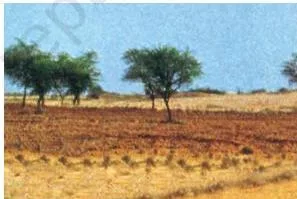
| Arid | Red to brown; sandy texture; saline in nature | Dry climate with high evaporation | Western Rajasthan | Lacks humus and moisture; lower horizons have Kankar due to increasing calcium content, which restricts infiltration of water | Cultivable after proper irrigation (as in western Rajasthan) | Common salt obtained by evaporating water in high-salt areas |
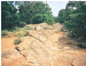
| Forest | Loamy and silty in valley sides; coarse grained on upper slopes | Mountain environment with sufficient rain forests | Hilly and mountainous areas of Himalayas | Experience denudation in snow-covered areas; acidic with low humus content | Not specified; valley soils on river terraces and alluvial fans are fertile | Texture varies according to the mountain environment where formed |


Bangar vs Khadar: The Misconception Autopsy
The Bangar vs Khadar confusion is the single most common mistake students make in alluvial soil questions. Use the table below to settle it.
| Feature | Bangar (old alluvial) | Khadar (new alluvial) |
|---|---|---|
| Age | Older alluvial soil | Newer alluvial soil, renewed almost every flood season |
| Kanker nodules | Higher concentration of kanker (calcium carbonate) nodules | Lower concentration of kanker nodules |
| Fertility | Less fertile than Khadar (because of higher kanker load and older, more degraded material) | More fertile — has more fine particles and is replenished by fresh silt |
| Location | Higher reaches of river valleys, away from active floodplains | Low-lying floodplains near the river course |
The simple test: if the soil is old, has more kanker nodules and is less fertile, it is Bangar. If it is newer, finer and more fertile, it is Khadar.
Soil Erosion Types and Conservation Techniques
Soil erosion is the denudation of the soil cover and the subsequent washing down of soil (NCERT, p. 10). The processes of soil formation and erosion usually go on simultaneously, and there is a balance between the two. This balance is disturbed by human activities like deforestation, overgrazing, construction and mining, or by natural forces like wind, glacier and water.

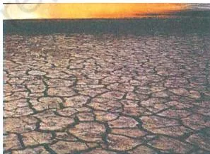
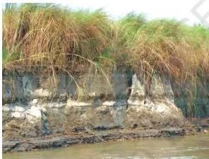
Note also the gully erosion image below (the photograph referenced in the caption). The three main types of erosion to know are:
| Erosion type | How it happens | Where in India | Resulting landform |
|---|---|---|---|
| Gully erosion | Running water cuts through clayey soils and makes deep channels called gullies | Chambal basin | Land becomes unfit for cultivation; known as bad land. In the Chambal basin, such lands are called ravines |
| Sheet erosion | Water flows as a sheet over large areas down a slope; top soil is washed away uniformly | Farming slopes with vegetation cover removed | Top soil removed as a sheet; soil fertility drops |
| Wind erosion | Wind blows loose soil off flat or sloping land | Arid and semi-arid flat tracts | Loosening of top soil; loss of fine particles |
Soil erosion is also caused by defective methods of farming — ploughing up and down a slope forms channels for quick flow of water and leads to erosion.
Four Key Conservation Methods
The four main soil conservation techniques are listed below with one-line explanations.
- Contour ploughing: Ploughing along the contour lines of a slope instead of up-and-down. It decelerates the flow of water down the slopes.
- Terrace cultivation: Cutting steps (terraces) on the slopes to restrict erosion. Western and central Himalayas have well-developed terrace farming.
- Strip cropping: Large fields are divided into strips, with strips of grass left to grow between the crops. This breaks up the force of the wind.
- Shelter belts: Rows of trees are planted to create shelter, which works in a similar way to strip cropping. Shelter belts have contributed significantly to the stabilisation of sand dunes and in stabilising the desert in western India.
Common Mistakes Students Make in This Chapter
Below are strict error-to-correction pairs that address common confusion points. Learn the rule and the quick check — it will save you marks.
| Mistake | Correct rule | How to check your answer |
|---|---|---|
| Writing that all resources are free gifts of nature | Resources are a function of human activities — material becomes a resource only through technology and institutions | Ask yourself: can humans use this material with current technology and profit? If so, it is a resource; otherwise, it is just nature |
| Mixing up Bangar and Khadar | Bangar = old alluvial with higher kanker nodules and lower fertility; Khadar = new alluvial with more fine particles and higher fertility | If the answer key says more fertile, the soil is Khadar. If it says more kanker, it is Bangar |
| Saying black soil is poor in all nutrients | Black soil is only poor in phosphoric contents. It is rich in calcium carbonate, magnesium, potash and lime | State all four nutrient categories explicitly: calcium carbonate, magnesium, potash and lime — rich; phosphorus — poor |
| Confusing gully erosion with sheet erosion | Gully erosion makes deep channels (like the Chambal ravines); sheet erosion washes away the topsoil uniformly as a sheet over a slope | If the answer key says deep channels, it is gully. If it says top soil washed off as a sheet, it is sheet erosion |
| Saying laterite soil is fertile everywhere | Laterite soil is humus rich under forests and humus poor under sparse vegetation or in semi-arid environments | Always specify the vegetation cover when describing laterite soil fertility — forest cover and dense vegetation means humus rich; sparse vegetation means humus poor |
| Attributing Punjab land degradation to overgrazing | In Punjab, Haryana and western Uttar Pradesh, land degradation is caused by over-irrigation; overgrazing is the cause in Gujarat, Rajasthan, Madhya Pradesh and Maharashtra | For Punjab, Haryana and western UP, use the term salinity/alkalinity from water logging; for western states, use overgrazing |
Exam Notes: What Examiners Look For in Resources and Development
The exam pointers below are observed patterns only, written with an examiner’s mindset. They are based on the textbook exercise structure and on the kinds of questions NCERT poses.
- 1-mark MCQ pattern: Exact state-resource pairings — for example, terrace cultivation with Uttarakhand (d), black soil with Maharashtra (b), or land degradation in Punjab caused by over-irrigation (c). State names earn the mark; do not leave them out.
- 30-word pattern: Short descriptive answers. For example, the textbook asks for three features of alluvial soil found in the eastern coastal deltas. Name three features explicitly — e.g., sand-silt-clay mix, high fertility, adequate potash/phosphoric acid/lime, deposited by rivers. Each feature earns the mark.
- 120-word pattern: Cause-and-effect reasoning. For example, explain why forest cover has not increased much since 1960-61, or how technical and economic development leads to more consumption of resources. The reasoning step — connecting the cause to the effect — earns the marks, not just a list of facts.
- Specific dates and conventions: Questions on the Rio Earth Summit 1992 and Agenda 21 reward dates and full names (the United Nations Conference on Environment and Development). Write 1992, Rio de Janeiro, Brazil, and Agenda 21 by name.
- Soil conservation methods: Often asked as a list — name the method and explain in one line (contour ploughing, terrace cultivation, strip cropping, shelter belts). One-line explanations are enough; long paragraphs waste time.
- State-cause mapping: For land degradation questions, the state-cause pairs earn a mark. Write both — Jharkhand = deforestation due to mining; Punjab = over-irrigation — and the effect, e.g., salinity and alkalinity.
Revision Recap: Quick Glance Before the Test
This is the night-before checklist for the chapter. Run through it one last time.
- Resource definition (3 conditions): technologically accessible, economically feasible, culturally acceptable (T-E-C triad).
- 4 classification bases: origin (biotic/abiotic); exhaustibility (renewable/non-renewable); ownership (individual/community/national/international); status of development (potential/developed stock/reserves).
- 3 steps of resource planning: identification and inventory (surveying, mapping, quantitative and qualitative estimation); evolving planning structure with technology, skill and institutions; matching with overall national development plans.
- Sustainable development definition: Development that meets present needs without damaging the environment or reducing the ability of future generations to meet their own needs.
- International milestones: 1968 Club of Rome; 1974 Schumacher (Small is Beautiful); 1987 Brundtland Commission (introduced Sustainable Development); 1992 Rio Earth Summit (Agenda 21, Forest Principles, Declaration on Global Climatic Change and Biological Diversity).
- India land relief: 43% plains, 30% mountains, 27% plateaus.
- 5 land use categories: Forests; land not available for cultivation; other uncultivated land; fallow lands (current / other than current); net sown area (with gross cropped area = area sown more than once plus NSA).
- Land use reporting: data available for 93% of total area; forest cover target 33% (National Forest Policy 1952); NSA over 80% in Punjab/Haryana, under 10% in Arunachal/Mizoram/Manipur/Andaman Nicobar.
- Land degradation state-cause pairs: Jharkhand, Chhattisgarh, MP, Odisha — deforestation due to mining; Gujarat, Rajasthan, MP, Maharashtra — overgrazing; Punjab, Haryana, western UP — over-irrigation leading to salinity/alkalinity; cement and ceramic zones — dust retards infiltration.
- 6 soil types — one key feature each: Alluvial — most widely spread and fertile; Black/Regur — clayey, holds moisture, deep cracks; Red and Yellow — iron diffusion gives red colour; Laterite — intense leaching, acidic (pH < 6); Arid — sandy, saline, low humus, kankar layer at bottom; Forest — loamy and silty in valley sides, coarse on upper slopes, acidic with low humus.
- Conservation methods (4): contour ploughing, terrace cultivation, strip cropping, shelter belts.
Frequently Asked Questions on Resources and Development
What is the difference between potential resources, developed stock and reserves?
Potential resources are found in a region but have not yet been used, because the technology or economic viability is not available. The developed stock refers to resources that have been surveyed, quantified and are currently being used. Reserves are the part of the developed stock that can be extracted profitably with existing technology and economic conditions.
Why is resource planning essential in India specifically?
Because India has enormous diversity in the availability of resources.
Some regions are rich in one type of resource but deficient in another: Jharkhand, Chhattisgarh and Madhya Pradesh are rich in minerals and coal; Arunachal Pradesh has water but lacks infrastructure; Rajasthan has solar and wind energy but lacks water; Ladakh is isolated and deficient in water, infrastructure and vital minerals.
Balanced resource planning at the national, state, regional and local levels helps fill these gaps.
What is the difference between net sown area and gross cropped area?
Net sown area (NSA) is the physical extent of land on which crops are sown and harvested in a given agricultural year — each plot is counted once. Gross cropped area (GCA) counts each time a plot is sown.
So if a plot is sown twice in the same agricultural year, it is added twice in the GCA but only once in the NSA. The formula is GCA = NSA + area sown more than once.
Which states in India have net sown area over 80 per cent and which have less than 10 per cent?
Net sown area is over 80 per cent of total area in Punjab and Haryana. It is less than 10 per cent in Arunachal Pradesh, Mizoram, Manipur and the Andaman and Nicobar Islands. The variation depends on topography, forest cover, climate and population pressure on land.
How does over-irrigation cause land degradation in Punjab, Haryana and western Uttar Pradesh?
Over-irrigation leads to water logging in the soil. As the stagnant water evaporates, it leaves behind salts, which raises the salinity and alkalinity of the soil. The soil structure breaks down and crop productivity falls.
What is the significance of the Rio de Janeiro Earth Summit 1992 and Agenda 21?
The Rio de Janeiro Earth Summit, 1992 was the first International Earth Summit, where more than 100 heads of states met to address environmental protection and socio-economic development. The signed documents include the Declaration on Global Climatic Change and Biological Diversity, the global Forest Principles and the adoption of Agenda 21.
Agenda 21 aims at achieving global sustainable development by combating environmental damage, poverty and disease. One major objective is that every local government should draw its own local Agenda 21.
Reference: NCERT Class 10 Geography (Contemporary India II) textbook, chapter 1, Resources and Development (official NCERT chapter page).
Explore Class 10 Geography Notes
Class 10 Geography on LearnCBSE:
Related chapters: