
These are the revision notes for Chapter 6, Planning and Sustainable Development in Indian Context, from NCERT’s Class 12 Geography book India: People and Economy. They follow the 2026-27 session.
Use them the night before a test to revise two big ideas — how India plans (target area and target group programmes) and what sustainable development looks like in practice (the Bharmaur and Indira Gandhi Canal case studies).
Every definition, programme, figure, and data point below follows the NCERT chapter, with page references such as (NCERT, p. 66) so you can look anything up quickly. This page is part of the Class 12 Geography notes on this site. The full chapter text is in the official NCERT PDF of Chapter 6 if you ever need to check the source wording.
What this chapter covers and in what order
The chapter builds from a general idea to two concrete case studies. If you learn it in this sequence, each part supports the next:
- Planning approaches — sectoral planning vs regional planning, and the shift from centralised planning to NITI Aayog.
- Target area and target group programmes — the full list you can be asked to classify.
- Drought Prone Area Programme — objectives, evolution, and the regions it covers.
- Case study 1 — Bharmaur — the Integrated Tribal Development Project and the Gaddi community.
- Sustainable development — how the meaning of development changed, ending with the Brundtland definition.
- Case study 2 — Indira Gandhi Canal command area — its two stages, positive transformation, and twin environmental problems.
- Seven sustainability measures — the chapter’s own recipe for fixing the command area.
Both case studies are the heart of the chapter. Expect to compare them with each other — the comparison table in the revision summary at the end of these notes does exactly that. For context in the same book, you can revise the mineral and energy resources chapter notes as a next step.
Browse all Class 12 notes or the full CBSE notes index if you are revising other subjects too.
Planning in India: sectoral and regional approaches
Planning, in everyday usage, means thinking, formulating a scheme, and implementing actions to reach a goal. In this chapter it is used specifically for economic development, and it is different from the traditional hit-and-miss method of reform and reconstruction (NCERT, p. 66).
India adopted centralised planning after Independence. Over time this graduated into decentralised multi-level planning. Plan formulation was earlier handled by the Planning Commission at the Centre, State, and district levels.
On 1 January 2015, the Planning Commission was replaced by the NITI Aayog, set up to involve the states in economic policy making and to give strategic and technical advice to the Central and State governments (NCERT, p. 66).
The chapter organises all planning into two approaches. Both appear in almost every answer, so keep their contrast clean:
| Basis | Sectoral planning | Regional planning |
|---|---|---|
| What is planned | Different sectors of the economy | Areas or spaces |
| Examples of sectors/areas | Agriculture, irrigation, manufacturing, power, construction, transport, communication, social infrastructure and services | Backward regions, hill areas, desert areas, tribal areas |
| Main aim | Development of each sector of the economy | Reducing regional imbalance in development |
| Why it exists | One planning approach that treats each economic sector separately | Because development is uneven over space — some areas lag behind |
Why regional planning exists: no country has uniform economic development over space. Since some areas are more developed and others lag behind, planners need a spatial perspective to draw plans that reduce regional imbalance (NCERT, p. 66).
Target area and target group programmes: the full list
After about one-and-a-half decades of planning experience, the Planning Commission realised that regional imbalances were getting accentuated, not reduced. To arrest this, it introduced the target area and target group approaches to planning (NCERT, p. 67). The two names are easy to mix up, so learn the logic: area names a place, group names a type of people.
| Target area programmes | Target group programmes |
|---|---|
| Command Area Development Programme | Small Farmers Development Agency (SFDA) |
| Drought Prone Area Development Programme | Marginal Farmers Development Agency (MFDA) |
| Desert Development Programme | |
| Hill Area Development Programme |
In the 8th Five Year Plan, special area programmes were designed to develop infrastructure in hill areas, north-eastern states, tribal areas, and backward areas (NCERT, p. 67).
Drought prone area programme: objectives, evolution and regions
The Drought Prone Area Programme (DPAP) is the chapter’s most detailed target area programme, and it is worth separate revision.
- Started: during the Fourth Five Year Plan.
- Objectives: provide employment to people in drought-prone areas and create productive assets (NCERT, p. 67).
How it evolved:
- Initially: construction of labour-intensive civil works.
- Later: irrigation projects, land development, afforestation, grassland development, and basic rural infrastructure such as electricity, roads, markets, credit, and services.
- The National Committee on Development of Backward Areas reviewed the programme and found it largely confined to agriculture and allied sectors, with the major focus on restoration of ecological balance.
Two official boundary-setting facts:
| Body and year | Criterion | Result |
|---|---|---|
| Planning Commission of India, 1967 | Identification based on proneness to drought | 67 districts (entire or partly) identified as drought-prone |
| Irrigation Commission, 1972 | 30 per cent irrigated area criterion | Demarcated the drought-prone areas |
Regions covered: the semi-arid and arid tract of Rajasthan and Gujarat, Western Madhya Pradesh, Marathwada in Maharashtra, the Rayalseema and Telangana plateaus of Andhra Pradesh, the Karnataka plateau and highlands, and the interior parts of Tamil Nadu. Drought-prone parts of Punjab, Haryana and north-Rajasthan are largely protected because irrigation has spread there (NCERT, p. 67).
Development strategy: adopt the integrated watershed development approach at the micro-level, and make the restoration of ecological balance between water, soil, plants, and human and animal populations a basic consideration. Since population pressure is pushing marginal lands into cultivation and causing ecological degradation, the chapter also calls for alternative employment opportunities in drought-prone areas (NCERT, pp. 67, 74).
Bharmaur and the Integrated Tribal Development Project: a case study
This is the chapter’s first full case study. Revise it in four blocks: location and people, physical setting, the ITDP strategy, and measurable outcomes.
Location and people
- Bharmaur tribal area comprises the Bharmaur and Holi tehsils of Chamba district, Himachal Pradesh.
- Notified as a tribal area on 21 November 1975.
- Inhabited by the Gaddi tribal community, who practised transhumance and spoke the Gaddiali dialect (NCERT, p. 68).
- 2011 census: total population of the Bharmaur sub-division was 39,113, i.e. 21 persons per sq km — one of the most economically and socially backward areas of Himachal Pradesh.
- Economy is largely based on agriculture and allied activities such as sheep and goat rearing.
Physical setting
- Lies between 32° 11′ N and 32° 41′ N latitudes, and 76° 22′ E and 76° 53′ E longitudes.
- Area about 1,818 sq km, mostly between 1,500 m and 3,700 m above mean sea level.
- Bounded by the Pir Panjal in the north and the Dhaula Dhar in the south; in the east the extension of Dhaula Dhar converges with Pir Panjal near Rohtang Pass.
- The river Ravi and its tributaries — the Budhil and the Tundahen — drain the territory and carve deep gorges, dividing it into four physiographic divisions: Holi, Khani, Kugti, and Tundah.
- Mean monthly temperature stays 4°C in January and 26°C in July, with freezing weather and snowfall in winter (NCERT, p. 68).
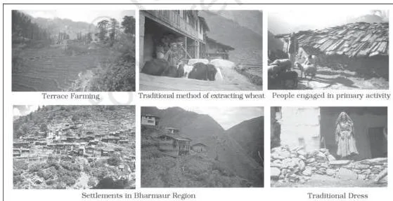
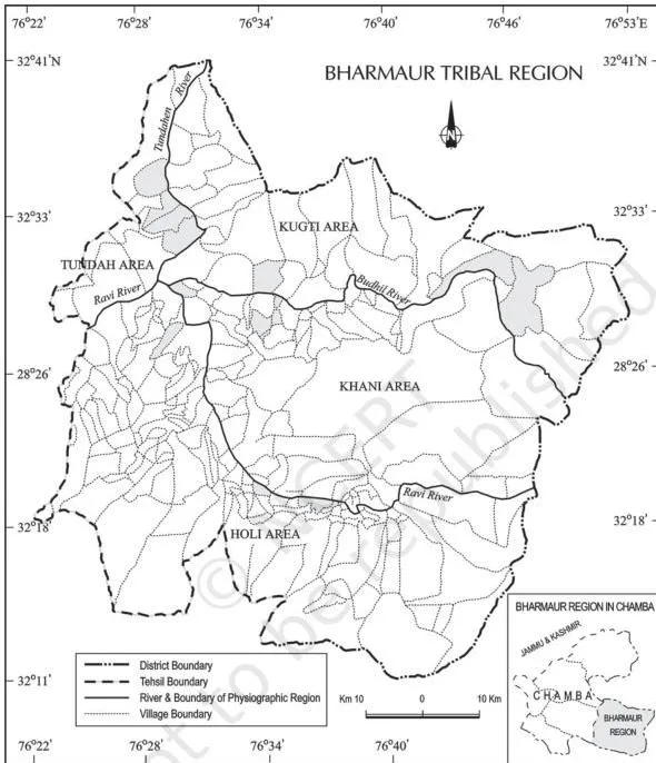
The textbook places these two figures with the Bharmaur case study (Fig. 6.1 and Fig. 6.2) so you can visualise the region described above.
The ITDP strategy
- Development of the tribal area began in the 1970s, when the Gaddis were included among the scheduled tribes.
- Under the Fifth Five Year Plan, the tribal sub-plan was introduced in 1974, and Bharmaur was designated one of the five Integrated Tribal Development Projects (ITDP) in Himachal Pradesh (NCERT, pp. 68-69).
- Aim: improve the quality of life of the Gaddis and narrow the development gap between Bharmaur and the rest of Himachal Pradesh.
- Priorities: transport and communications, agriculture and allied activities, and social and community services.
Measurable outcomes
- Infrastructure: schools, healthcare facilities, potable water, roads, communications, and electricity. Main beneficiaries are villages along the river Ravi in Holi and Khani; remote villages in Tundah and Kugti still lack sufficient infrastructure (NCERT, pp. 69-70).
- Social benefits: tremendous rise in literacy, improvement in sex ratio, and decline in child marriage.
- Female literacy rose from 1.88 per cent in 1971 to 65 per cent in 2011, and gender inequality in literacy declined (NCERT, p. 70).
- Economic shift: from a subsistence agricultural-cum-pastoral economy of foodgrains and livestock towards pulses and other cash crops, though traditional technology is still used in cultivation.
- Decline of pastoralism: only about one-tenth of households now practise transhumance; a sizeable section still migrates to Kangra and surrounding areas in winter for wage labour.
Sustainable development: from economic growth to the Brundtland Report
The meaning of development changed in stages over the second half of the twentieth century. Learn the stages in order, because the Brundtland definition only makes sense as the final step.
- Post-World War II era: development was synonymous with economic growth, measured by the increase in gross national product (GNP) and per capita income or consumption.
- The problem: even countries with high economic growth experienced a speedy rise in poverty because growth was unequally distributed.
- 1970s: the phrases redistribution with growth and growth and equity were incorporated into the definition of development.
- Widening scope: development was realised to include well-being and living standards, health, education, equality of opportunity, and political and civil rights.
- 1980s: development emerged as a concept of widespread improvement in the social as well as material well-being of all people in a society (NCERT, p. 70).
How the idea of sustainable development emerged:
- A general rise in environmental awareness in the Western World in the late 1960s, reflecting concern over the undesirable effects of industrial development on the environment.
- The Population Bomb by Ehrlich (1968) and The Limits to Growth by Meadows and others (1972) raised the level of public fear.
- The United Nations set up the World Commission on Environment and Development (WCED), headed by Norwegian Prime Minister Gro Harlem Brundtland.
- The Commission’s 1987 report, Our Common Future (the Brundtland Report), defined sustainable development as:
“a development that meets the needs of the present without compromising the ability of future generations to meet their own needs” (NCERT, p. 70).
Sustainable development takes care of the ecological, social, and economic aspects of development and pleads for conservation of resources so that future generations can use them too.
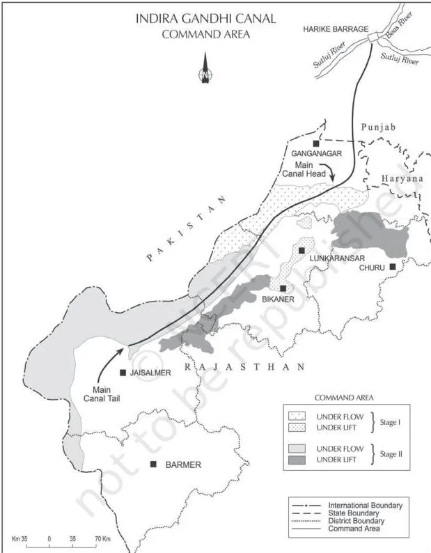
Indira Gandhi Canal command area: a development story with two sides
This second case study is the chapter’s biggest data block, and it is deliberately two-sided: the canal transformed a desert economy but also created environmental damage.
Canal basics
- Formerly the Rajasthan Canal; one of the largest canal systems in India.
- Conceived by Kanwar Sain in 1948; launched on 31 March 1958.
- Originates at the Harike barrage in Punjab and runs parallel to the Pakistan border at an average distance of 40 km in the Thar Desert (Marusthali) of Rajasthan.
- Total planned length: 9,060 km; total culturable command area: 19.63 lakh hectares.
- About 70 per cent of the command area was envisaged to be irrigated by flow system and the rest by lift system (NCERT, p. 72).
- In a lift canal, water is lifted to make it flow against the slope of the land. All lift canals originate at the left bank of the main canal; all canals on the right bank are flow channels.
Stage I vs Stage II
| Feature | Stage I | Stage II |
|---|---|---|
| Districts | Ganganagar, Hanumangarh, and northern part of Bikaner | Bikaner, Jaisalmer, Barmer, Jodhpur, Nagaur, and Churu |
| Culturable command area | 5.53 lakh hectares | 14.10 lakh hectares |
| Irrigation began | Early 1960s | Mid-1980s |
| Topography | Gently undulating | Desert land with shifting sand dunes; temperatures soaring to 50°C in summers |
Note the subtle detail: Bikaner appears in both stages — its northern part in Stage I and the rest in Stage II (NCERT, p. 72).
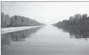
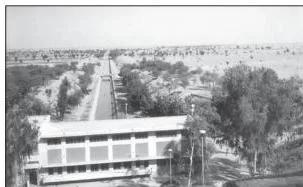
Fig. 6.4 shows the Indira Gandhi Canal itself, and Fig. 6.5 shows the canal and its adjoining areas (NCERT, p. 72).
Positive transformation
- Soil moisture is available for a longer period, and afforestation plus pasture development under CAD have resulted in greening of the land.
- This greening reduced wind erosion and siltation of the canal systems.
- Cultivated area and intensity of cropping increased.
- Traditional crops — gram, bajra, and jowar — were replaced by wheat, cotton, groundnut, and rice.
- Agricultural and livestock productivity increased tremendously in the initial period (NCERT, pp. 72-73).
Negative impacts
- Intensive irrigation and excessive use of water produced the twin environmental problems of waterlogging and soil salinity.
- In the long run, these problems hamper the sustainability of agriculture (NCERT, p. 73).
Seven measures for sustainable development in the command area
The chapter proposes seven measures for the Indira Gandhi Canal command area. Scholars had questioned the ecological sustainability of the project, and the region’s development over four decades validated their point — so five of the seven measures aim to restore ecological balance, one is social, and one is economic (NCERT, p. 73).
- Strict implementation of water management policy. The project envisages protective irrigation in Stage I and extensive irrigation of crops and pasture development in Stage II.
- Cropping pattern without water-intensive crops. People shall be encouraged to grow plantation crops such as citrus fruits.
- CAD works: lining of water courses, land development and levelling, and the warabandi system (equal distribution of canal water in the command area of an outlet) to reduce conveyance loss of water.
- Reclamation of areas affected by waterlogging and soil salinity.
- Eco-development through afforestation, shelterbelt plantation, and pasture development, especially in the fragile environment of Stage II.
- Social measure: land allottees with a poor economic background must get adequate financial and institutional support for cultivation of land.
- Economic measure: diversification of the economic base — agricultural and allied activities must develop along with other sectors, establishing functional linkages between basic villages, agro-service centres, and market centres.
Definitions at a glance
| Term | Meaning | Example from the chapter |
|---|---|---|
| Planning | The process of thinking, formulating a scheme or programme, and implementing actions to achieve a goal; used here for economic development (NCERT, p. 66) | Planning for an exam, applied to the economy |
| Sectoral planning | Schemes aimed at development of various sectors of the economy | Separate programmes for agriculture, power, transport |
| Regional planning | Planning with a spatial perspective to reduce regional imbalance | Hill Area Development Programme |
| Target area approach | Programmes for areas that have remained economically backward | Drought Prone Area Development Programme |
| Target group approach | Programmes for particular backward social or economic groups | Small Farmers Development Agency (SFDA) |
| ITDP | Integrated Tribal Development Project — the chapter’s exercise words the correct option as Integrated Tribal Development Programme | Bharmaur, one of five ITDPs in Himachal Pradesh |
| Transhumance | The seasonal movement of people with their livestock between pastures | The Gaddis moving with sheep and goats |
| Sustainable development | “a development that meets the needs of the present without compromising the ability of future generations to meet their own needs” (NCERT, p. 70) | The aim behind the seven canal measures |
| Brundtland Report | The 1987 report titled Our Common Future, given by the WCED headed by Gro Harlem Brundtland | Source of the standard definition |
| Warabandi | Equal distribution of canal water in the command area of an outlet | Measure (iii) for the canal command area |
| Watershed development | Integrated micro-level approach in drought-prone areas that restores ecological balance between water, soil, plants, and human and animal populations | Strategy for drought-prone areas |
| Waterlogging | Saturation of soil with water caused by intensive irrigation and excessive water use | Twin problem with soil salinity in the canal command area |
Key data and indicators: the numbers that carry answers
Honest note: this chapter has no formulas. In a data-heavy Geography chapter, this table plays the role a formula list plays in Physics or Maths — quote these figures precisely in answers.
| Data point | Value | Context |
|---|---|---|
| NITI Aayog formed | 1 January 2015 | Replaced the Planning Commission (NCERT, p. 66) |
| Bharmaur notified as tribal area | 21 November 1975 | Chamba district, Himachal Pradesh (NCERT, p. 68) |
| Bharmaur area | 1,818 sq km | Altitude mostly 1,500 m to 3,700 m (NCERT, p. 68) |
| Bharmaur population (2011) | 39,113 persons | Density 21 persons per sq km (NCERT, p. 68) |
| Bharmaur temperatures | 4°C in January; 26°C in July | Mean monthly temperature (NCERT, p. 68) |
| Bharmaur female literacy | 1.88 per cent (1971) to 65 per cent (2011) | ITDP social benefit (NCERT, p. 70) |
| Canal planned length | 9,060 km | Indira Gandhi Canal system (NCERT, p. 72) |
| Total culturable command area | 19.63 lakh ha | Stage I + Stage II (NCERT, p. 72) |
| Stage I command area | 5.53 lakh ha | Ganganagar, Hanumangarh, northern Bikaner (NCERT, p. 72) |
| Stage II command area | 14.10 lakh ha | Bikaner to Churu districts (NCERT, p. 72) |
| Flow vs lift | 70 per cent flow; 30 per cent lift | Lift canals on left bank, flow canals on right bank (NCERT, p. 72) |
| Drought-prone districts | 67 districts (1967); 30 per cent irrigated area criterion (1972) | Planning Commission and Irrigation Commission (NCERT, p. 67) |
| Hill area criterion | Height above 600 m | National Committee on Development of Backward Areas, 1981 (NCERT, p. 67) |
Worked example: using the chapter’s data step by step
This chapter rewards answers that compare data instead of just listing it. Here is a fully worked example using the chapter’s own figures, with every step shown so you can copy the style in an answer.
Step 1: Find the total culturable command area by adding Stage I and Stage II.
\[ 5.53 + 14.10 = 19.63\ \text{lakh ha} \]
Step 2: Calculate Stage I’s share of the total.
\[ \frac{5.53}{19.63} = 0.282 \Rightarrow 28.2\% \]
Step 3: Calculate Stage II’s share either directly or as the remainder.
\[ \frac{14.10}{19.63} = 0.718 \Rightarrow 71.8\% \]
Step 4: Calculate the rise in Bharmaur’s female literacy between 1971 and 2011.
\[ 65 – 1.88 = 63.12\ \text{percentage points} \]
Step 5: Write one interpretive sentence that connects both results.
Interpretation: Stage II carries about 71.8 per cent of the canal’s total command area, so the desert districts of Stage II dominate the project’s scale; meanwhile, Bharmaur’s female literacy rose by 63.12 percentage points in four decades, showing how sharply the ITDP’s social benefits registered.
Common mistakes and how to avoid them
| Mistake | Correct rule | How to check your answer |
|---|---|---|
| Writing that sectoral planning develops areas | Sectoral planning develops sectors of the economy; regional planning develops areas to reduce regional imbalance | Ask yourself: am I naming an economic sector (agriculture, power) or a region (hill, desert)? |
| Mixing up target area and target group programmes | Target area = Command Area, Drought Prone Area, Desert, Hill Area programmes; target group = SFDA and MFDA | Is the programme named after a place or after a type of people? |
| Expanding ITDP as Integrated Tourism Development Programme | ITDP means Integrated Tribal Development Project (the chapter’s exercise words its correct option as Integrated Tribal Development Programme) — never tourism, travel, or transport | The T in ITDP stands for Tribal, connected to the Gaddi case study |
| Saying Bikaner appears only in Stage II | Bikaner appears in both stages: its northern part in Stage I and the rest in Stage II | Quote “northern part of Bikaner” when listing Stage I districts |
| Swapping the plans: DPAP in the Fifth Plan, HADP in the Fourth | Drought Prone Area Programme began in the Fourth Five Year Plan; Hill Area Development Programme was initiated in the Fifth Five Year Plan | Attach each programme to its plan once and revise from the timeline table below |
| Swapping the drought-boundary facts | The Planning Commission (1967) identified 67 drought-prone districts; the Irrigation Commission (1972) used the 30 per cent irrigated area criterion | Keep the year with the body: 1967 + districts; 1972 + percentage |
| Presenting canal irrigation as an unqualified success | The chapter wants both sides: transformation of agriculture and the twin problems of waterlogging and soil salinity | End any canal answer with one line on environmental cost |
Exam notes: structuring answers to this chapter’s exercises
This chapter’s questions fall into two length bands, and each needs a different skeleton.
Short answers (around 30 words)
- Open with the term or definition itself. If the word appears in the question, define it in your very first sentence.
- Add one precise fact from the key data table — a number, a year, or a name makes the answer specific.
- Close with a one-line outcome — what changed, improved, or resulted.
For example, if you are asked to define the concept of sustainable development, the complete answer is the Brundtland definition quoted in quotation marks and attributed to the 1987 report Our Common Future (NCERT, p. 70).
Long answers (around 150 words)
Use a four-part skeleton:
- Definition and context — introduce the programme or concept.
- Programme details and data — plan, objectives, criteria, and the numbers that define it.
- Case study evidence — a concrete outcome, like female literacy rising to 65 per cent, or the shift from gram and bajra to wheat and cotton.
- Measures or conclusion — suggestions for sustainability, or a balanced statement of both positive and negative impacts.
A complete long answer on a canal question names the positive transformation and the twin problems; a complete answer on drought-prone areas states the 1967 and 1972 boundary facts and the watershed approach. Related data-heavy chapters in the same book, such as the transport and communication chapter notes, reward this same four-part structure.
Revision summary: timeline and memory aids
One compact timeline removes most plan-mix-ups. Link every date to its context:
| Year | Event | Context / Five Year Plan |
|---|---|---|
| 1948 | Indira Gandhi Canal conceived by Kanwar Sain | Pre-project idea |
| 1958 | Canal project launched on 31 March | Rajasthan Canal, later Indira Gandhi Canal |
| 1967 | Planning Commission identified 67 drought-prone districts | Drought Prone Area Programme boundary |
| 1968 | The Population Bomb by Ehrlich | Rise of environmental awareness |
| Fourth Plan | Drought Prone Area Programme initiated | Employment and productive assets |
| 1972 | Irrigation Commission’s 30 per cent irrigated area criterion; The Limits to Growth by Meadows | Drought demarcation; environmental literature |
| 1974 | Tribal sub-plan introduced; Bharmaur designated an ITDP | Fifth Five Year Plan |
| 1975 | Bharmaur notified as a tribal area on 21 November | Status of the region |
| Fifth Plan | Hill Area Development Programme initiated | 15 districts including hilly districts of UP (now Uttarakhand), Assam, West Bengal, Tamil Nadu |
| 1981 | National Committee recommended hill areas above 600 m be treated as backward | Hill area criterion |
| 1987 | Brundtland Report, Our Common Future | WCED headed by Gro Harlem Brundtland |
| 8th Plan | Special area programmes for hill areas, north-eastern states, tribal areas, backward areas | Infrastructure development |
| 2011 | Census data: Bharmaur population 39,113; female literacy 65 per cent | ITDP outcome evidence |
| 2015 | NITI Aayog formed on 1 January | Replaced the Planning Commission |
Memory device for the seven measures
Remember the seven sustainability measures as 5-1-1: five restore ecological balance (water management, cropping pattern, CAD works, reclamation, eco-development), one is social (support for poor land allottees), and one is economic (diversification of the economic base).
Case study comparison: Bharmaur ITDP vs Indira Gandhi Canal command area
These two case studies are often weighed against each other. This table lines them up on the four dimensions the chapter emphasises:
| Aspect | Bharmaur ITDP | Indira Gandhi Canal command area |
|---|---|---|
| Objective | Improve the quality of life of the Gaddis and narrow the development gap with the rest of Himachal Pradesh (NCERT, pp. 68-69) | Irrigate the Thar Desert and transform its dryland agriculture (NCERT, p. 72) |
| Strategy | Tribal sub-plan, with priority on transport and communications, agriculture and allied activities, and social and community services (NCERT, p. 69) | Two-stage canal with 70 per cent flow and 30 per cent lift irrigation, plus CAD works such as lining, land development, and warabandi (NCERT, pp. 72-73) |
| Social benefits | Rise in literacy and sex ratio, decline in child marriage; female literacy from 1.88 per cent (1971) to 65 per cent (2011) (NCERT, p. 70) | Increase in cultivated area and cropping intensity; shift from gram, bajra, jowar to wheat, cotton, groundnut, rice (NCERT, p. 72) |
| Environmental cost | Fragile mountain environment; remote villages in Tundah and Kugti still lack sufficient infrastructure (NCERT, pp. 69-70) | Waterlogging and soil salinity from intensive irrigation, which hampers long-run sustainability (NCERT, p. 73) |
FAQs: planning and sustainable development class 12 notes
What is the difference between sectoral planning and regional planning?
Sectoral planning formulates schemes for the development of different sectors of the economy — agriculture, irrigation, manufacturing, power, transport, and services. Regional planning takes a spatial perspective and draws plans to reduce regional imbalance, because development is uneven over space (NCERT, p. 66).
Which programmes in this chapter are target area programmes and which are target group programmes?
Target area programmes: Command Area Development Programme, Drought Prone Area Development Programme, Desert Development Programme, and Hill Area Development Programme. Target group programmes: Small Farmers Development Agency (SFDA) and Marginal Farmers Development Agency (MFDA) (NCERT, p. 67).
Why did the Indira Gandhi Canal cause waterlogging and soil salinity despite increasing farm output?
Because irrigation was intensive and water use was excessive. The twin problems of waterlogging and soil salinity emerged from this overuse, and although productivity rose initially, in the long run these problems hamper the sustainability of agriculture (NCERT, pp. 72-73).
What exactly is the Brundtland definition of sustainable development?
From the 1987 report Our Common Future, sustainable development is “a development that meets the needs of the present without compromising the ability of future generations to meet their own needs” (NCERT, p. 70).
How do flow canals and lift canals differ in the Indira Gandhi Canal system?
A flow canal lets water move by gravity along the land’s slope. A lift canal raises water so it can flow against the slope.
In this system, all lift canals originate at the left bank of the main canal, while all canals on the right bank are flow channels; about 70 per cent of the command area uses flow and 30 per cent uses lift (NCERT, p. 72).
Why did the Gaddis shift away from transhumance and pastoralism?
The chapter records the shift rather than giving a single cause: only about one-tenth of households now practise transhumance, while a sizeable section still migrates to Kangra and surrounding areas in winter to earn from wage labour. At the same time, cultivation of pulses and cash crops increased, reducing the relative importance of pastoralism in the regional economy (NCERT, p. 70).
Reference: NCERT Class 12 Geography textbook (India: People and Economy), chapter 6.
Explore Class 12 Geography Notes
- Class 12 Geography Notes
- Class 12 CBSE Notes
- CBSE Notes for Classes 1 to 12
- Previous: Mineral and Energy Resources
- Next: Transport and Communication
Class 12 Geography on LearnCBSE:
Related chapters:
- International Trade notes
- Geographical Perspective on Selected Issues and Problems notes
Official source: download the NCERT textbook free from ncert.nic.in.