
Need the Transport and Communication chapter for Class 12 Geography in shorter, revision-ready form?
These notes compress Chapter 7 of the NCERT Fundamentals of Human Geography (text pages 54–69) into the essentials: what transport and communication actually do, the four modes and the cargo each suits, the world’s major rail lines, sea routes, canals, airways and pipelines, and the leap from telegraph to cyberspace. They follow the 2026-27 session.
The page is built for last-minute revision — jump straight to any section through the contents below, use the data tables to fix facts, and end with the common-mistakes table so the wrong facts don’t stick. Every idea here comes from the NCERT text, with page references where they help you recheck the original.
These notes form part of the complete Class 12 Geography notes on this site.
Why transport and communication matter
Natural resources, markets and economic activities are rarely found in one place. That single fact explains the whole chapter: transport, communication and trade link producing centres to consuming centres (NCERT, p. 54). Each region produces what it is best suited to produce, and trade in those commodities depends on transport and communication.
High living standards and quality of life, in turn, depend on efficient transport, communication and trade.
Two ideas are worth fixing early:
- In earlier times, the means of transport and communication were the same; today each has acquired distinct and specialised forms (p. 54).
- Geographically, transport is the network of links and carriers through which trade takes place — this definition is the backbone of the chapter (p. 54).
- Assured, speedy transport plus efficient communication promotes cooperation and unity among scattered peoples, and every nation develops transport for defence as well (p. 54).
The flows of goods this chapter describes are analysed further in the International Trade chapter notes of the same book. If you want the full text, maps and exercises, the official NCERT textbook PDF for this chapter is available on ncert.nic.in.
The four modes of transport and how they complement each other
Transport is the service or facility for carrying persons and goods from one place to another, using humans, animals and different kinds of vehicles, over land, water and air (NCERT, p. 54).
It is also an organised service industry made of three parts: the arteries (routes), the vehicles that move on them, and the organisation that maintains the arteries and handles loading, unloading and delivery.
A transport network is the pattern that results when several places (called nodes) are joined by a series of routes (called links) (p. 54). The four principal modes are land, water, air and pipelines; every mode except pipelines carries both passengers and freight.
Why does one mode win over another? Three factors decide: the type of goods and services to be moved, the cost of transport, and the availability of the mode (p. 55). On that basis:
- Ocean freighters handle international movement — the oceans are a connected, free highway, so the cost per tonne is lowest for bulky goods between continents.
- Roads are cheaper and faster over short distances and give door-to-door service.
- Railways suit large volumes of bulky materials over long distances within a country.
- Airways suit high-value, light and perishable goods, where speed justifies the cost.
The chapter’s key phrase: in a well-managed transport system, these modes complement each other, they do not compete (p. 55). Think of a relay race — the truck sprints the short first lap, the train or ship runs the long middle leg, and the aeroplane takes over when time matters. Each runner does the stage it is built for.
| Cargo situation | Distance / urgency | Best mode |
|---|---|---|
| Bulky, low-value freight (wheat, ores, coal, timber) moving far within a country | Long distance, low urgency | Rail |
| International cargo of almost any bulk, continent to continent | Very long distance, low-to-moderate urgency | Ocean freighters / sea route |
| Small loads needing doorstep delivery | Short distance, high urgency | Road |
| Light, high-value, perishable cargo (cut flowers, electronics) | Long or international, high urgency | Air |
| Liquids and gases (water, petroleum, natural gas); even liquefied coal and milk | Fixed corridor, continuous demand | Pipelines |
| Heavy cargo along a wide, deep river (coal, cement, timber) | Inland, moderate distance, low urgency | Inland waterways |
Transport as an organised service is itself a tertiary activity — the same idea is developed in the Tertiary and Quaternary Activities notes for this course.
Land transport: roads, railways and trans-continental routes
Early land transport and pack animals
Land transport evolved in stages: humans as carriers → beasts of burden → the wheel (carts and wagons) → the steam engine in the eighteenth century → the internal combustion engine → today’s pipelines, ropeways and cableways (NCERT, p. 55).
The first public railway line opened in 1825 between Stockton and Darlington in northern England, and railways opened up continental interiors for commercial grain farming, mining and manufacturing in the U.S.A.
Odd but true: the oldest forms of transport are the most expensive per unit of load, while large freighters are the cheapest. That is why human porters and carts still appear in the densely populated districts of India and China, supplementing modern carriers that cannot reach every interior point (p. 55). Pack animals are chosen by terrain:
| Animal | Where it works |
|---|---|
| Horses | Draught animals even in Western countries |
| Dogs and reindeer | Draw sledges over snow in North America, North Europe and Siberia |
| Mules | Preferred in mountainous regions |
| Camels | Caravan movement in deserts |
| Bullocks | Pull carts in India |
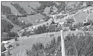
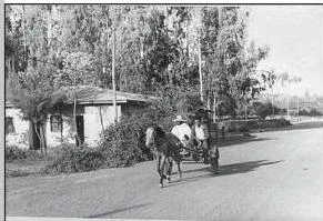
The two photographs above contrast the old and the new: the horse cart still works where roads are poor, while ropeways and cable cars (Fig. 7.1) are normally found on steep mountain slopes and at mines where building roads is not suitable (p. 55).
Roads, highways and border roads
Roads are the most economical mode for short distances and freight by road is growing because it offers door-to-door service (NCERT, p. 56). But unmetalled roads become unmotorable in the rainy season, and even metalled roads are handicapped in heavy rains and floods — one reason rail, with its high embankments, remains essential.
The world’s total motorable road length is only about 15 million km, and North America accounts for 33 per cent of it, with the highest road density and the highest number of vehicles.
- Congestion: city roads suffer chronic congestion, with peaks at rush hours and troughs between them. The chapter’s remedies: higher parking fees, Mass Rapid Transit (MRT), improved public bus service and expressways (p. 56).
- Highways are metalled roads about 80 m wide, with separate lanes, bridges, flyovers and dual carriageways for unobstructed movement (p. 56). North American highway density is about 0.65 km per sq km, putting every place within 20 km of a highway.
- Border roads are roads laid along international boundaries — they integrate people in remote areas with major cities and serve defence by carrying goods to border villages and military camps (p. 57).
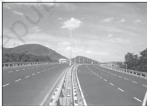
Named highways to know by heart (p. 56–57): the Trans-Canadian Highway (Vancouver to St. John’s City), the Alaskan Highway (Edmonton to Anchorage), the Pan-American Highway (planned to connect South America, Central America and U.S.A.–Canada), the Trans-Continental Stuart Highway (Darwin to Melbourne via Tennant Creek and Alice Springs), the Moscow–Vladivostok Highway, and India’s Golden Quadrilateral joining New Delhi, Mumbai, Chennai and Kolkata.
In Africa, highways link Algiers to Conakry and Cairo to Cape Town.
Railways and their regional pattern
Railways move bulky goods and passengers over long distances. Track widths, or gauges, are classified as broad (more than 1.5 m), standard (1.44 m), metre (1 m) and smaller; the standard gauge is used in the U.K. (NCERT, p. 57). About 13 lakh km of railways are open for traffic in the world.
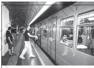
Commuter trains are popular in the U.K., U.S.A., Japan and India, and the Tube in Vienna (Fig. 7.4) is a typical underground system.
Each region of the world has a distinctive rail pattern worth quoting in answers:
| Region | Rail facts to quote |
|---|---|
| Europe | About 4,40,000 km, mostly double or multiple track; Belgium has the highest density — 1 km of railway per 6.5 sq km; London and Paris are linked by the Channel Tunnel |
| Russia | About 90 per cent of the country’s transport; dense network west of the Urals; Moscow the most important rail head |
| North America | Nearly 40 per cent of the world’s rail network; used mainly for long-distance freight (ores, grains, timber, machinery) |
| Australia | About 40,000 km, with 25 per cent in New South Wales; National Railway line from Perth to Sydney |
| South America | Densest in the Pampas of Argentina and the coffee region of Brazil (together 40 per cent of route length); a trans-continental line links Buenos Aires to Valparaiso across the Uspallatta Pass at 3,900 m |
| Asia | Densest in Japan, China and India; West Asia is the least developed in rail facilities |
| Africa | Only about 40,000 km in the second-largest continent; South Africa alone has 18,000 km; important lines include the Benguela Railway and the Blue Train (Cape Town to Pretoria) |
Trans-continental railways
A trans-continental railway runs across a continent and links its two ends, built for economic and political reasons (NCERT, p. 58). The chapter presents five of them:
| Railway | Termini | Key details |
|---|---|---|
| Trans-Siberian (Russia) | St Petersburg (west) – Vladivostok (east) | 9,332 km — the longest double-tracked, electrified line in the world; via Moscow, Ufa, Novosibirsk, Irkutsk, Chita and Khabarovsk |
| Trans-Canadian (Canada) | Halifax (east) – Vancouver (west) | 7,050 km; built in 1886; via Montreal, Ottawa, Winnipeg and Calgary |
| Union and Pacific (U.S.A.) | New York (Atlantic) – San Francisco (Pacific) | Via Cleveland, Chicago, Omaha, Ogden and Sacramento; exports ores, grain, paper, chemicals and machinery |
| Australian Trans-Continental | Perth (west) – Sydney (east) | Via Kalgoorlie, Broken Hill and Port Augusta; a north-south line from Adelaide to Alice Springs is to join the Darwin-Birdum line |
| Orient Express (Europe) | Paris – Istanbul | Via Strasbourg, Munich, Vienna, Budapest and Belgrade; London to Istanbul now takes 96 hours against 10 days by sea |
Three of these routes are mapped in the figures below — the Trans-Siberian, the Trans-Canadian and the Australian line.
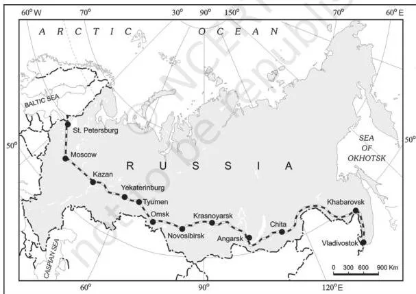
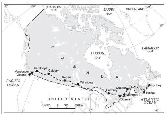
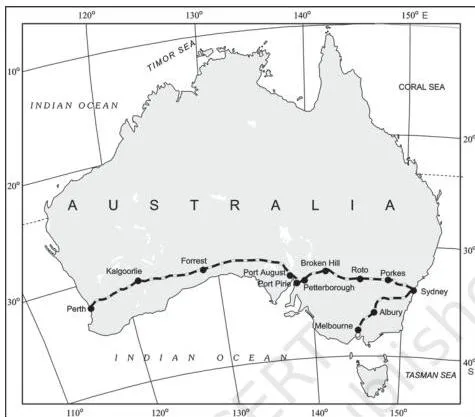
To keep the five lines in order, use the first letters — Siberian, Canadian, Union-Pacific, Australian, Orient — as: “Some Cats Usually Adore Old railways.”
Reading the railway maps: a figure walkthrough
The three maps above are the chapter’s only railway maps, and exam-style questions often demand exact termini. Read any trans-continental map in three steps (NCERT, p. 58–60):
- Find the two terminal cities — a true trans-continental line has its two ends on opposite coasts of the same continent.
- Trace the corridor of intermediate cities between them; these cities are the ones the textbook expects you to name.
- Look at the side branches — loops and connecting lines show what the route is economically tied to.
Applied to Fig. 7.5 (Trans-Siberian): the western end is St Petersburg and the eastern end is Vladivostok on the Pacific; the corridor runs Moscow → Ufa → Novosibirsk → Irkutsk → Chita → Khabarovsk. The map’s route crosses the Ural Mountains and the Ob and Yenisei rivers.
The connecting links dropping south — to Odessa, Baku, Tashkent, Ulan Bator, Shenyang and Beijing — show why the line opened up Russia’s Asian region to West European markets (p. 58–59). Chita is an agro-centre and Irkutsk a fur centre.
Applied to Fig. 7.6 (Trans-Canadian): termini are Halifax (east) and Vancouver (Pacific coast), with Montreal, Ottawa, Winnipeg and Calgary along the way. The detail to spot is the loop line from Winnipeg to Thunder Bay on Lake Superior — it connects the railway to the Great Lakes waterway.
This line is the economic artery of Canada, joining the Quebec–Montreal industrial region with the Prairie wheat belt; wheat and meat are its important exports (p. 59).
Applied to Fig. 7.7 (Australian): the west-east line runs Perth → Kalgoorlie → Broken Hill → Port Augusta → Sydney. A separate north-south connector, Adelaide to Alice Springs (to be joined to the Darwin-Birdum line), is not part of this trans-continental route.
That last point is the whole map-reading skill: a trans-continental line spans the continent coast to coast, while a north-south connector like Adelaide–Alice Springs has only one coastal end and feeds traffic toward a coast. When asked to identify a railway on a blank map, first ask: do both ends touch the sea?
Water transport: sea routes, canals and inland waterways
Why water transport is cheap
Water transport needs no route construction — the oceans are already linked and negotiable; all that is needed is port facilities at the two ends (NCERT, p. 60). It is much cheaper because the friction of water is far less than that of land, so the energy cost is lower.
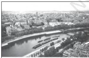
The Seine, seen from the Eiffel Tower in Fig. 7.8, shows how a river through a city becomes a working inland waterway.
Modern shipping improved through radar and wireless navigation aids, refrigerated chambers for perishables, tankers and specialised ships, and containers, which make cargo handling at major ports easier (p. 61). Try the textbook activity here: locate some important ports of the U.S.A. and Western Europe in an atlas (p. 62).
The major sea routes
| Route | Connects | Signature fact |
|---|---|---|
| Northern Atlantic (Big Trunk Route) | North-eastern U.S.A. ↔ north-western Europe | Busiest in the world; one-fourth of world’s foreign trade |
| Mediterranean-Indian Ocean | Through the heart of the Old World — Port Said, Aden, Mumbai, Colombo, Singapore | Serves more countries and people than any other route |
| Cape of Good Hope | Western Europe ↔ West Africa, South Africa, South-east Asia, Australia, New Zealand | Traffic growing with gold, diamond, copper, groundnut, oil palm and coffee |
| Southern Atlantic | West Europe and West Africa ↔ Brazil, Argentina, Uruguay | Light traffic; little between Rio de Janeiro and Cape Town |
| North Pacific | West coast of North America ↔ Asian ports | Routes converge at Honolulu; the Great Circle Vancouver–Yokohama halves the distance (2,480 km) |
| South Pacific | Western Europe and North America ↔ Australia, New Zealand, Pacific islands (via Panama) | Panama to Sydney is 12,000 km; Honolulu is a key port |
| Coastal shipping | Ports along a single long coastline (U.S.A., China, India) | Can reduce congestion on land routes |
Suez versus Panama
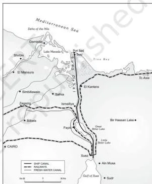
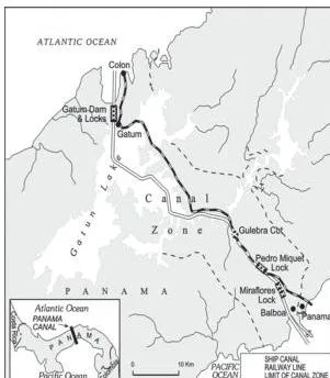
Both canals are man-made navigation gateways of commerce, but students mix them up constantly — the differences in the table are the ones to remember (NCERT, p. 63–64).
| Feature | Suez Canal | Panama Canal |
|---|---|---|
| Built | 1869, in Egypt | Across the Panama Isthmus (the U.S. purchased 8 km on either side as the Canal Zone) |
| Connects | Mediterranean Sea ↔ Red Sea (Port Said to Port Suez) | Atlantic Ocean ↔ Pacific Ocean (Panama City to Colon) |
| Length and depth | About 160 km, 11–15 m deep | About 72 km, with deep cutting for 12 km |
| Locks | None — a sea-level canal | Six-lock system; ships are moved 26 m up and down |
| Traffic | About 100 ships daily; 10–12 hours to cross | — |
| Distance saved | Greatly shortens routes like Liverpool–Colombo versus the Cape of Good Hope | Shortens New York–San Francisco by 13,000 km |
| Significance | Europe’s gateway to the Indian Ocean | Economically less significant than Suez, but vital to Latin America |
Inland waterways
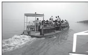
Rivers, canals, lakes and coastal areas carry cargo and passengers where conditions allow. The suitability of a waterway — its navigability — depends on the width and depth of the channel, the continuity of water flow, and the transport technology in use (NCERT, p. 64). Fig. 7.12 shows the ideal: a river wide, deep and free of silt.
Rivers are often the only means of transport in dense forests, and very heavy goods — coal, cement, timber, metallic ores — move well by water. Dredging, bank stabilisation and dams or barrages are used to improve navigability.
The five waterways the chapter expects you to name (p. 65–66):
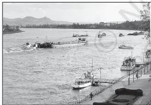
- Rhine: flows through Germany and the Netherlands, navigable for 700 km from Rotterdam to Basel; ocean-going vessels reach Cologne. It is the most heavily used waterway in the world — over 20,000 ocean-going ships and 2,00,000 inland vessels exchange cargoes annually (Fig. 7.13).
- Danube: serves Eastern Europe; rises in the Black Forest and flows east; chief exports are wheat, maize, timber and machinery.
- Volga: Russia’s most important waterway — 11,200 km of navigable water — draining into the Caspian Sea; the Volga-Moscow and Volga-Don canals link it outward.
- Great Lakes–St. Lawrence Seaway: Lakes Superior, Huron, Erie and Ontario joined by the Soo and Welland Canals; ocean vessels reach Montreal, where rapids force trans-shipment to smaller vessels.
- Mississippi-Ohio: connects the interior U.S.A. with the Gulf of Mexico; large steamers reach Minneapolis.
Air transport and pipelines: speed and bulk
Air transport
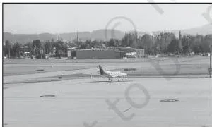
Air transport is the fastest but most costly mode, so it is chosen when speed or inaccessibility matters (NCERT, p. 66). It is often the only way into areas blocked by mountainous snowfields, deserts or landslide-prone terrain — in the Himalayan region, for instance, air travel is sometimes the only alternative when landslides, avalanches or heavy snowfall obstruct routes.
It also has great strategic importance.
- The cost of airports and aircraft support — hangars, landing, fuelling and maintenance facilities — is enormous, so airports have developed most in highly industrialised countries.
- No place in the world is more than 35 hours away; travel by air is measured in hours and minutes.
- The U.K. pioneered commercial jet transport; the U.S.A. developed post-War international civil aviation. Today more than 250 commercial airlines operate, and supersonic aircraft cover London–New York in three and a half hours.
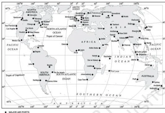
Inter-continental air routes form a distinct east-west belt in the Northern Hemisphere, dense over Eastern U.S.A., Western Europe and South-east Asia (p. 66). The U.S.A. alone accounts for 60 per cent of the world’s airways.
The nodal cities where air routes converge are: New York, London, Paris, Amsterdam, Frankfurt, Rome, Moscow, Karachi, New Delhi, Mumbai, Bangkok, Singapore, Tokyo, San Francisco, Los Angeles and Chicago. Africa, Asian Russia and South America lack dense air services, and there are limited services between 10° and 35° South latitudes because of sparser population, limited landmass and lower economic development.
Fig. 7.16 shows the worldwide distribution of major airports.
Pipelines
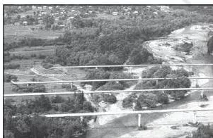
Pipelines carry liquids and gases — water, petroleum and natural gas — for an uninterrupted flow (NCERT, p. 66–67). They can also move liquefied coal, and in New Zealand milk is supplied through pipelines from farms to factories.
- In the U.S.A., a dense network of oil pipelines links producing to consuming areas; Big Inch carries petroleum from the Gulf of Mexico to the North-eastern States. About 17 per cent of all freight per tonne-km in the U.S.A. moves by pipeline.
- In Europe, Russia, West Asia and India, pipelines connect oil wells to refineries, ports and domestic markets; Turkmenistan has extended pipelines to Iran and parts of China.
- The proposed Iran–India via Pakistan oil and natural gas pipeline would be the longest in the world.
Communications: from telegraph to cyberspace
Unlike transport, which moves bodies and goods, communication moves information. The chapter traces one continuous story: each new technology made data travel faster, more securely and more cheaply (NCERT, p. 67–68).
| Stage | What changed |
|---|---|
| Telegraph | Instrumental in the colonisation of the American West |
| Telephone | AT&T held a monopoly in the U.S.A. in the early-mid twentieth century; the telephone became a critical factor in American urbanisation — firms kept headquarters in cities and branches in smaller towns |
| Optic fiber cables (OFC) | Telephone companies upgraded copper cables; OFCs transmit large data volumes rapidly, securely and virtually error-free |
| Digitisation in the 1990s | Telecommunication merged with computers to form integrated networks — the Internet |
| Satellite communication (1970s onward) | Artificial satellites in the earth’s orbit connect even remote corners of the globe; the unit cost and time of communication become invariant with distance — the same cost over 500 km as over 5,000 km |
| Cyberspace / Internet | E-mail, e-commerce, e-learning and e-governance expand the contemporary economic and social space of humans |
India’s satellite milestones, in order: Aryabhatt (launched 19 April 1975), Bhaskar-I (1979), Rohini (1980) and APPLE (Arian Passenger Payload Experiment, 19 June 1981); INSAT I-B later made long-distance communication, television and radio very effective (p. 68). Today, cell phones — made possible by satellites — are central to rural connectivity in developing countries.
Cyberspace is “the world of electronic computerised space”, the electronic digital world for communicating or accessing information over computer networks without the physical movement of sender and receiver (p. 68). It exists everywhere — an office, a sailing boat, a flying plane. Its spread is unprecedented: under 50 million Internet users in 1995, about 400 million in 2000, over 2 billion in 2010, and about 5.4 billion in 2023.
The U.S.A.’s share of users fell from 66 per cent in 1995 to 25 per cent in 2005 as users shifted toward developing countries. It is these modern communication systems, more than transportation, that have made the global village a reality.
Definitions you should be able to reproduce
These are the chapter’s working terms. Learn them as meaning + example so that a definition can be written from memory in one sentence.
| Term | Meaning | Example |
|---|---|---|
| Transport | A service or facility for carrying persons and goods from one place to another using humans, animals and vehicles (p. 54) | Steel carried by truck; passengers by train |
| Transport network | A pattern formed when places (nodes) are joined by routes (links) (p. 54) | A city and its towns tied by roads and rail lines |
| Road density | Length of roads per unit area, showing how well a region is served (p. 56) | North America’s 0.65 km per sq km |
| Border roads | Roads laid along international boundaries, for integration and defence (p. 57) | Roads feeding border villages and military camps |
| Trans-continental railway | A railway running across a continent, linking its two ends (p. 58) | Trans-Siberian Railway |
| Big Trunk Route | The Northern Atlantic sea route, the busiest in the world (p. 62) | North-eastern U.S.A. ↔ north-western Europe |
| Shipping canal | A man-made navigation waterway serving as a gateway of commerce (p. 63) | Suez and Panama canals |
| Navigability | The suitability of a waterway for boats, set by width, depth, water flow and technology (p. 64) | The Rhine, navigable for 700 km |
| Satellite communication | Communication through artificial satellites, with cost and time invariant with distance (p. 68) | Cell phone calls, cable television |
| Cyberspace | The electronic digital world for communicating or accessing information without physical movement (p. 68) | The Internet, e-mail, e-commerce |
Key numbers and data to remember
This chapter has no formulas, but its data points behave like formulas — they decide objective-type answers. Revise them from this table (page references in the second column locate each figure in the textbook).
| Data point | Page |
|---|---|
| World motorable roads: about 15 million km; North America’s share 33 per cent | p. 56 |
| North America highway density: 0.65 km per sq km (every place within 20 km of a highway) | p. 56 |
| World railways: about 13 lakh km | p. 57 |
| Belgium’s railway density: 1 km per 6.5 sq km — the highest | p. 57 |
| Europe’s rail network: about 4,40,000 km; North America: nearly 40 per cent of the world’s total | p. 57–58 |
| Trans-Siberian Railway: 9,332 km; Trans-Canadian: 7,050 km (built 1886) | p. 58–59 |
| Orient Express: London to Istanbul in 96 hours (against 10 days by sea) | p. 60 |
| Suez Canal: about 160 km, 11–15 m deep, about 100 ships daily, 10–12 hours to cross, no locks | p. 63 |
| Panama Canal: about 72 km, six locks, 26 m rise; New York–San Francisco shortened by 13,000 km | p. 63–64 |
| Rhine: navigable 700 km; 20,000 ocean-going ships and 2,00,000 inland vessels exchange cargoes yearly | p. 65 |
| Volga: 11,200 km of navigable waterway | p. 65 |
| North Pacific Great Circle (Vancouver–Yokohama) halves a 2,480 km distance; Panama–Sydney 12,000 km (South Pacific) | p. 63 |
| U.S.A.’s share of world airways: 60 per cent; no place more than 35 hours away | p. 66 |
| U.S.A. pipelines: about 17 per cent of all freight per tonne-km; Big Inch carries petroleum | p. 67 |
| India’s satellites: Aryabhatt (19 April 1975), Bhaskar-I (1979), Rohini (1980), APPLE (19 June 1981) | p. 68 |
| Internet users: less than 50 million (1995), about 400 million (2000), over 2 billion (2010), about 5.4 billion (2023); U.S.A. share 66 per cent (1995) → 25 per cent (2005) | p. 68 |
Worked example: choosing a transport mode for a cargo
The whole chapter’s logic reduces to one decision: what mode for what cargo? Use the principle-first method shown below — name the rule, apply it step by step, then state why the other modes fail. The same logic is used in the mode-choice table above.
Scenario 1: 40 tonnes of steel from Jamshedpur to a factory 80 km away
Principle: roads are cheaper and faster over short distances and provide door-to-door service (NCERT, p. 55).
- Distance is short (80 km) — road territory.
- The destination is a single factory — a truck delivers straight to the gate.
- Rail would need loading at a station plus a truck for the last leg (double handling), and air is absurd for 40 tonnes of steel.
Decision: road (truck). The alternatives fail because they add handling and lose the door-to-door advantage.
Scenario 2: 2,000 tonnes of wheat from Punjab to a port, about 1,500 km away
Principle: railways suit large volumes of bulky materials over long distances within a country (p. 55).
- Wheat is bulky and low-value — it cannot bear high freight costs.
- The distance is long but entirely within one country — rail’s home ground.
- Road would need countless trips; there is no river for such a haul; air would cost far more than the wheat is worth.
Decision: rail. It moves the full volume in one train consist at the lowest cost over that distance.
Scenario 3: 3 tonnes of cut flowers from Pune to Dubai
Principle: high-value, light and perishable goods are best moved by airways (p. 55).
- Flowers are perishable — speed is non-negotiable.
- The load is light (3 tonnes) — air freight remains affordable.
- The value is high — the flowers can absorb the air fare.
- Sea would take days (flowers would rot); road and rail cannot cross the sea.
Decision: air. Every slower alternative fails the perishability test.
Scenario 4: natural gas from a field to a city 600 km away
Principle: pipelines transport liquids and gases for an uninterrupted flow (p. 66).
- Gas cannot be loaded like solid freight — it needs sealed conveyance.
- The demand is continuous (city supply), so a pipe gives uninterrupted flow with no repeated loading.
- Road or rail tankers would need constant re-handling and offer no storage advantage.
Decision: pipeline. It is the only mode built for continuous, trouble-free flow of gas over a fixed route.
Common mistakes to avoid in Transport and Communication
These six confusions cost the most marks in this chapter. Each row gives the wrong idea, the correct fact and the reason behind it.
| Students write… | Correct is… | Why |
|---|---|---|
| The Big Trunk Route lies along the Mediterranean–Indian Ocean | The Big Trunk Route is the Northern Atlantic sea route, linking north-eastern U.S.A. with north-western Europe (p. 62) | It carries one-fourth of the world’s foreign trade — the dense “trunk” of traffic that makes it the busiest route |
| Russia has the highest railway density | Belgium has the highest density — 1 km of railway for every 6.5 sq km (p. 57) | Russia’s network is huge but spread over a vast area; its density is high only west of the Urals |
| The Trans-Siberian runs from Moscow to Vladivostok | It runs from St Petersburg to Vladivostok; Moscow is an intermediate station (p. 58) | Moscow is Russia’s hub, so it is assumed to be the terminus — but the line’s western end is St Petersburg |
| The Suez Canal uses locks; the Panama Canal is sea-level | Reversed: Suez is a sea-level canal without locks; Panama has a six-lock system with a 26 m rise (p. 63–64) | Suez joins two seas at nearly the same level; Panama crosses a mountainous isthmus, so ships must be lifted |
| The Danube is the world’s most heavily used waterway | The Rhine is the most heavily used — over 20,000 ocean-going ships and 2,00,000 inland vessels yearly (p. 65) | The Rhine runs through the prosperous Ruhr coalfield manufacturing basin |
| The U.S.A. holds nearly 40 per cent of the world’s railways | North America holds nearly 40 per cent of the rail network; the U.S.A.’s 60 per cent figure is its share of world airways | Two different percentages for two different modes — 40 per cent railways (North America), 60 per cent airways (U.S.A.) |
How to write complete answers for this chapter
The chapter’s exercises on p. 69 ask for answers in about 30 words and in not more than 150 words. Use these two templates and the question-by-question plan below.
- 30-word answers: open with a definition in one sentence, add one named example or one specific factor, then close in one sentence. Two or three sentences total.
- 150-word answers: state the point you will prove, give three supporting ideas each with a named example, then a one-line conclusion.
What each exercise topic needs in a complete answer:
- Problems of road transport in mountainous, desert and flood-prone regions (30-word format): one concrete problem per terrain — routes obstructed by landslides, avalanches and heavy snowfall in mountains; dependence on pack animals rather than roads in deserts; unmetalled roads becoming unmotorable, and even metalled roads handicapped, in heavy rains and floods (p. 55–56).
- What is a trans-continental railway (30 words): definition (runs across a continent linking its two ends) + purpose (economic and political) + one example with termini, such as the Trans-Siberian from St Petersburg to Vladivostok (p. 58).
- Advantages of water transport (30 words): no route construction needed; oceans are already linked; only two ports are required; lower energy cost because the friction of water is less than that of land; suits heavy bulky cargo (p. 60).
- “In a well managed transport system, various modes complement each other” (150 words): name the statement, then give three complementarity examples — rail carries wheat in bulk to a port while roads distribute it door-to-door; ocean freighters bring goods between continents and roads/rails spread them inland; air takes perishable goods where speed and terrain rule out the others. Conclude that each mode works best in its own stage (p. 55).
- Regions with a dense network of airways (150 words): Eastern U.S.A., Western Europe and South-east Asia; the U.S.A.’s 60 per cent share of world airways; the east-west belt of the Northern Hemisphere; the nodal cities; and the limited services between 10° and 35° South due to sparse population, small landmass and lower development (p. 66).
- How cyberspace expands the contemporary economic and social space of humans (150 words): define cyberspace, then expand via e-mail, e-commerce, e-learning and e-governance; support with the Internet growth figures (under 50 million users in 1995 to about 5.4 billion in 2023); close with the global village statement (p. 68).
The choose-the-right-answer questions on p. 69 test exactly the facts collected in the key-numbers table and the mistakes table above — the Stuart Highway, Belgium’s railway density, the Big Trunk Route, Big Inch and the Channel Tunnel.
Revision summary: the chapter in one table
| Mode | Best suited for | Star examples | Key number or phrase |
|---|---|---|---|
| Land — roads | Short distances, door-to-door service, tourism, trade | Golden Quadrilateral, Trans-Canadian Highway, Stuart Highway | 15 million km of roads; 33 per cent in North America |
| Land — railways | Bulky freight and passengers over long distances within a country | Trans-Siberian, Trans-Canadian, Union and Pacific | 13 lakh km of railways; Belgium 1 km per 6.5 sq km |
| Water — sea routes | Cheap haulage of bulky material between continents | North Atlantic (Big Trunk), Suez and Panama canals | One-fourth of world’s foreign trade on the Big Trunk Route |
| Water — inland | Heavy cargo along wide, deep rivers | Rhine, Danube, Volga, Great Lakes–St. Lawrence, Mississippi | Rhine is the world’s most heavily used waterway |
| Air | Fast long-distance travel; valuable and perishable cargo | Nodal cities: New York, London, Paris, Tokyo, Singapore | U.S.A. 60 per cent of world airways; no place more than 35 hours away |
| Pipelines | Liquids and gases in uninterrupted flow | Big Inch, proposed Iran-India via Pakistan line | 17 per cent of U.S.A. freight per tonne-km |
The communication story in one line: telegraph → telephone → optic fiber cables → satellite communication → Internet/cyberspace → global village (p. 67–68).
For every subject and class, the CBSE notes index collects all pages, and the Class 12 notes portal groups them by subject for revision season.
Quick answers: frequently asked questions
Why is the North Atlantic sea route the busiest in the world?
Because it links the two most industrially developed regions of the world — north-eastern U.S.A. and north-western Europe — both with advanced ports (NCERT, p. 62).
The foreign trade on this route is greater than that of the rest of the world combined, and one-fourth of the world’s foreign trade moves along it, which is why it is called the Big Trunk Route.
What is the difference between the Suez Canal and the Panama Canal?
Suez (built 1869, Egypt) is about 160 km long, links the Mediterranean and Red Seas, and is a sea-level canal without locks; about 100 ships cross it daily. Panama is about 72 km long, links the Atlantic and Pacific Oceans, and uses a six-lock system that moves ships 26 m up and down; it shortens the New York–San Francisco voyage by 13,000 km (p. 63–64).
Panama’s economic significance is less than Suez’s but vital to Latin America.
Which is the longest trans-continental railway and which cities does it connect?
The Trans-Siberian Railway, at 9,332 km, is the longest double-tracked, electrified trans-continental line in the world. It runs from St Petersburg to Vladivostok, passing through Moscow, Ufa, Novosibirsk, Irkutsk, Chita and Khabarovsk, and crossing the Ural Mountains and the Ob and Yenisei rivers (p. 58–59).
Why are roads preferred for short distances while railways suit long hauls?
Roads are cheaper and faster over short distances and give door-to-door service, so no second vehicle is needed at either end (p. 55–56). Railways suit large volumes of bulky materials over long distances within a country and, with their high embankments, keep running through heavy rains and floods.
In a well-managed system the two are not rivals — rail covers the long middle leg and roads handle the collection and distribution at both ends.
What is cyberspace and how does it make the global village a reality?
Cyberspace is the electronic digital world for communicating or accessing information over computer networks, without the sender and receiver physically moving (p. 68). Through e-mail, e-commerce, e-learning and e-governance it expands human economic and social space. Because these modern communication systems — more than transportation — erase distance and time in information exchange, they have made the global village a reality.
Which country has the highest density of railway network?
Belgium, with a density of 1 km of railway for every 6.5 sq km (p. 57). The Russian network is far longer, but Belgium is small and densely tracked, giving it the highest density in the world.
Reference: NCERT Class 12 Fundamentals of Human Geography textbook, chapter Transport and Communication.
Explore Class 12 Geography Notes
- Class 12 Geography Notes
- Class 12 CBSE Notes
- CBSE Notes for Classes 1 to 12
- Previous: Tertiary and Quaternary Activities
- Next: International Trade
Class 12 Geography on LearnCBSE:
Related chapters:
- The World Population notes
- Human Development notes
- Primary Activities notes